Route Editor

| Guide | ♦ | 30 Triplogs | 1 Topic |
details | drive | no permit | forecast | map |
stats |
photos | triplogs | topic | location |
| 326 | 30 | 1 |
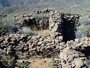
Seldom seen, passed by many by joebartels  Overview OverviewSteep but short off-trail hike to ruins you've likely driven past many times. A good option for those dead-of-winter wake-up-late days. Summary Anybody that's driven north on I-17 has passed these ruins. You know the routine... Phoenix, Anthem, Black Canyon City, and then there's that haul up the mesa towards the rest stop. Well, the mesa directly on your right is Black Mesa. These ruins are at the very southern tip. This section of the mesa is slightly separated from the mass.
Key notes: 1. Follow the fence line north up about 40 yards 2. Aim a hundred yards north of the tip of the mesa as to avoid some small cliffs. I recommend boots, jeans, and a long sleeve shirt for this off-trail jaunt. Preferably go on a cool 60-degree day or you'll be sweatin' buckets going up. The lower half of the ascent is close and personal with the vegetation. It gives away soon before becoming annoying. The ascent is steep. It's slightly steeper than Camelback or Piestewa but nothing as bad as Seven Cataracts or Black Cross Butte. The soil is pretty loose so be careful not to slip backward. There are a variety of chollas, prickly pear, and Saguaro awaiting your mistakes. Just be wise in your path of choice and you'll be fine. On top of the mesa, you'll quickly notice how the soil is soft and aerated. Since the hike is short and the ruins are the highlight I decided to explore the mesa top first. Next, I explored a bit around the eastern face of the ruins checking out the rock art. Dave Wilson, author of the book "Ruins Seldom Seen", best describes the ruins. It should go without saying but if you happen to find any artifacts don't take them. You aren't doing science any favors in preserving history in your home. Furthermore, it's illegal. It's pretty obvious why the Indians bolted out of this site... the highway noise below never goes away! Tag on the fact everybody is flooring it to ascend the mesa. Whew, it's enough to drive you nuts at times. This is a nice short off-trail hike for north valley residents, at least once anyhow. It would serve as a good addition if you were on your way to one of the short hikes in Sedona. Ruin enthusiasts will appreciate the hike most. However, I wouldn't recommend driving up from Tucson or down from Flagstaff just for this hike.
Check out the Triplogs. Leave No Trace and +Add a Triplog after your hike to support this local community. | |||||||||||||||||||||||||||||||||||||||||||||||||||||||||||||||||||||||||||||||||||