 Route Editor

| Guide | ♦ | 3 Triplogs | 0 Topics |
details | drive | permit | forecast | 🔥 route |
stats |
photos | triplogs | topics | location |
| 37 | 3 | 0 |
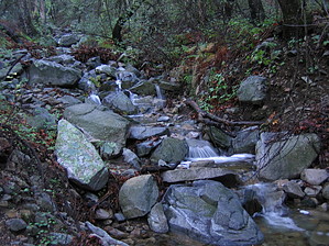
Brutal pleasure by fricknaley  There are a bunch of Agua Caliente's in Southern Arizona... canyons, rivers, hills. Well, here's another one - Agua Caliente Saddle - and it's one to remember. This saddle sits on the western edge of Maderna Canyon and looks east over the Canyon towards Wrightson and the Santa Rita ridgeline. It is a beautiful area, untouched by the Florida fire. Like many beautiful things, though, it takes some real work to get there. Today, I created a wonderfully painful route, incorporating Agua Caliente Saddle as the midpoint, with severe climbs on either side. Why? Because well all love to climb, I guess. There are a bunch of Agua Caliente's in Southern Arizona... canyons, rivers, hills. Well, here's another one - Agua Caliente Saddle - and it's one to remember. This saddle sits on the western edge of Maderna Canyon and looks east over the Canyon towards Wrightson and the Santa Rita ridgeline. It is a beautiful area, untouched by the Florida fire. Like many beautiful things, though, it takes some real work to get there. Today, I created a wonderfully painful route, incorporating Agua Caliente Saddle as the midpoint, with severe climbs on either side. Why? Because well all love to climb, I guess.Hike I started this trip from the official trailhead shared by Old Baldy and the Super Trail. The route of approach is the Vault Mine/Very Steep trail. I have described this route on a separate trip before. You may reference that if you please. Briefly, this first leg is a tough, short climb. As you start on the Baldy Trail, in roughly 0.25 miles, you come to the signed breakoff for Old Baldy proper. Stay right (or straight) onto the Vault Mine/Very Steep trail. It continues climbing up the canyon. There are beautiful sycamores here and just an incredible assortment of birds cruising about (including my first ever Elegant Trogon sighting). In roughly another 0.25 miles, you come to a signed intersection for Vault Mine and Carrie Nation trail. Break off right here and let the fun begin. This trail now climbs wildly up the western flank of Madera Canyon, gaining about 1300 feet in a little less than a mile. The views and fragrant pines inspire you because you get more amazing views increasingly down Madera Canyon as you go.
The upper reaches of the Agua Caliente trail are in a pristine pine forest, and they are STEEP. So much so that you will blaze down the path very fast. The trail drops down into a canyon (Agua Caliente on some maps, Rattlesnake on others) and follows it down, down, down the southern slopes of the Santa Ritas. The views south are long. You will pass a couple of abandoned mines on your left (Treasure Vault Mines). Eventually, you level out a little and descend into more high desert/low forest vegetation. This area of the Santa Ritas is very remote, isolated, and quite rugged. Pretty cool. As you wander along, there will probably be some trees and branches lying over the trail. I don't think too many folks come out this way. Nonetheless, the trail is never difficult to follow. Eventually, you stumble upon a dirt forest road. This is where the Agua Caliente Trailhead is. You can start the hike here too. I have in the past. However, the road is pretty rocky, and it takes a while to get there. Plus, hiking through Madera Canyon is always excellent. It is about 2 miles or so from the Saddle to this trailhead. Have a snack and power up. The climb back actually gains more elevation than the Vault Mine trail. You will climb about 2200 feet in roughly 2 miles. It is tough, but the views coming back are lovely. You will now notice the telescope perched atop the impossibly green and lush appearing Mt. Hopkins to your right. There are peaks everywhere. Near the top, you can spy Pete Mountain to your left. The last couple of switchbacks are painful, and I think the final switchback is the steepest and longest one I have ever climbed. Finally, back at the saddle, the views east towards the main ridgeline are just great. Head back the way you came to complete this roughly 8 mile, 4075 total elevation gain screamer. For the mileage, I don't know if there is more elevation to be gained around here. This is an excellent training hike if you have a big climb coming up too. Check out the Official Route and Triplogs. Note This is a more difficult hike. It would be unwise to attempt this without prior experience hiking. Leave No Trace and +Add a Triplog after your hike to support this local community. | ||||||||||||||||||||||||||||||||||||||||||||||||||||||||||||||||||||||||||||||||||||||||||||


