This is a worthy short hike when taking a walk down Ash Creek. The vegetation is excellent, with grassy glades, meadows, and aspen stands. Plus, you can bag a 10,000+ foot summit.
The easiest way to climb Webb Peak is off the Ash Creek trail. Roughly 0.5 miles into the Ash Creek trail, there is a signed intersection for Webb Peal Trail (345), which breaks off to your left. Follow this old track and slowly start to climb. There are many downed trees during the first part of the wide trail that you must scramble over. As you work your way around them, the trail will soon break off to your left and narrow somewhat.
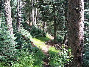
There are fantastic aspen stands and pines everywhere. You walk through a couple of grassy glades that are a treat for those of us in southern Arizona. The trail keeps winding slightly left, sometimes narrowing and sometimes widening out. After about 1 mile, it passes through a sweet meadow. There are some more downed trees, and some have been cut through. Occasionally when the trail peters out, some well-placed cairns will help you. Finally, you will come to a spot where the path seems to get very faint. This is a very short distance from the peak. Look to your left and climb over some downed trees to pick up the trail, which follows a timber cut line. This section is very short, and you soon come upon the summit. To your left and up is the lookout that you can climb for great vista views. The elevation marker says 10,029.
You can follow the same way back to the Ash Creek Trail (which I did), or you can continue on the Webb Peal trail for about 1 mile to the parking area/campground at the Ash Creek Trailhead.
WARNING! Hiking and outdoor related sports can be dangerous. Be responsible and prepare for the trip. Study the area you are entering and plan accordingly. Dress for the current and unexpected weather changes. Take plenty of water. Never go alone. Make an itinerary with your plan(s), route(s), destination(s) and expected return time. Give your itinerary to trusted family and/or friends.
Permit $$
None
Coronado Forest MVUMs are rarely necessary to review unless mentioned in the description or directions Coronado Motor Vehicle Use Maps (MVUMs)
Directions
Road
FR / Dirt Road / Gravel - Car Okay
To hike The trailhead can be accessed from either the Ash Creek Trail (Webb Peak takes off about 0.5 miles into Ash Creek Trail) or from the Ash Creek Trailhead at Columbine Campground.
 Route Editor

 This is a worthy short hike when taking a walk down Ash Creek. The vegetation is excellent, with grassy glades, meadows, and aspen stands. Plus, you can bag a 10,000+ foot summit.