username
X
password
register
for free!
help
   🔥

Dutch John Trail #91, AZ

Guide 16 Triplogs  1 Topic
  3 of 5  
Fav
Wish
2
details
drive
permit
forecast
🔥
route  
stats
photos
triplogs
topic
location
57 16 1
Statistics
tap row or icons for details
Difficulty 2.5 of 5
Route Finding 1 of 5
Distance One Way 0.9 miles
Trailhead Elevation 5,078 feet
Elevation Gain 951 feet
Accumulated Gain 951 feet
Avg Time One Way 1 hour
Kokopelli Seeds 4.07
feature photo
Photos Viewed All MineFollowing
5  2017-06-08
Dutch John Spring
markthurman53
2  2015-05-26 mdfabbrini
5  2014-01-04 wha
3  2009-08-22 leadhiker
7  2006-11-20 fricknaley
Author
author avatar Guides 93
Routes 397
Photos 4,984
Trips 4,124 map ( 27,424 miles )
Age 49 Male Gender
Location Tucson, AZ
Associated Areas
list map done
Tucson Region
Historical Weather
Trailhead Forecast
Radar Map
Expand Map
Preferred Mar, Nov, Apr, Feb → 8 AM
Seasons   Spring to Autumn
Sun  6:01am - 6:43pm
Official Route & 4 Rts
 
1 Alternative
 
Historic Fire Perimeteracres
🔥 2005 Florida Fire23.2k


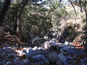
The Dutchman Heads South?
by fricknaley

The short hike to Dutch John Spring in Madera Canyon of the Santa Ritas is nothing spectacular, but it certainly is a nice little hike in a great place. It's a good one if you are spending the day in Madera Canyon and want a short little hike with a decent climb attached or could function as a "desert hike" to something else you were there to do. Either way, it's a pleasant little jaunt along a small canyon to an old spring with some nice vegetation along the way.


The easiest way to start this hike is out of the Nature Trail and Amphitheater parking lot on the right side of the road as you head up Madera Canyon. Cross over the street and see a small sign marking a trailhead for both Bog/Kent Springs and Dutch John Trail #91. Follow this well-maintained spur trail for about 0.6 miles as it cuts through some scrub-type vegetation and tall grass. There are periodic views of the Santa Rita crest as you go. The trail dead-ends at an old jeep track, which is signed. Head left for a short descent into the Bog Springs Campground. At the circular campground take a right and follow the gravel road for less than 0.1 miles to a signed trailhead for Dutch John Spring on your right.
remove free decal offer
Hop onto the Dutch John Trail #91 and start heading up the mountain. This section of the trail to the spring is fairly steep and gets your heart rate going a little. It crosses over a streambed as it climbs up the gulley into Dutch John Canyon which will end up n your left. There is nice shaded vegetation as you climb. Squirrels and occasional Coues White-tailed Deer cruise around. After about a mile or so a small spur breaks to the left, down to the signed Dutch John Spring. There are some nice Arizona Sycamores here, a small amount of running water and plenty of shade. The trail continues up past the spring for those who want to climb more, though I'm not currently sure where it goes.

2006-11-20 fricknaley


    Check out the Official Route and Triplogs.
    Leave No Trace and +Add a Triplog after your hike to support this local community.

    One-Way Notice
    This hike is listed as One-Way.

    When hiking several trails on a single "hike", log it with a generic name that describes the hike. Then link the trails traveled, check out the example.
    WARNING! Hiking and outdoor related sports can be dangerous. Be responsible and prepare for the trip. Study the area you are entering and plan accordingly. Dress for the current and unexpected weather changes. Take plenty of water. Never go alone. Make an itinerary with your plan(s), route(s), destination(s) and expected return time. Give your itinerary to trusted family and/or friends.

     Permit $$
    Visit overview & permits.
    2024 - FAQ
    $8 per vehicle per day
    $10 per vehicle per week
    $40 per vehicle per year (valid for one year from the date of purchase)

    There are four specific day-use areas that require a Coronado Recreational Pass or a National Pass/America the Beautiful Pass.
    1) Sabino Canyon - located on the Santa Catalina Ranger District (520)749-8700
    2) Madera Canyon - located on the Nogales Ranger District (520)281-2296
    3) Cave Creek - located on the Douglas Ranger District (520)364-3468
    4) Mt. Lemmon at 11 day-use sites.

    2022 Catalina State Park
    Per vehicle (1-4 Adults): $7.00
    Individual/bicycle: $3.00

    2022 Sabino Canyon Tram is $15 extra. [ website ]

    Coronado Forest
    MVUMs are rarely necessary to review unless mentioned in the description or directions
    Coronado Motor Vehicle Use Maps (MVUMs)


     Directions
    or
     Road
    Paved - Car Okay

    To hike
    Take I-10 into Tucson and get on I-19 South. Leave Interstate 19 at the Continental Road/Madera Canyon Exit. Turn east and follow the signs 13 miles to Madera Canyon Recreation Area. The signed Nature Trail and Amphitheater parking lot is on the right side of the road, just past the Santa Rita Lodge.
     90+° 8am - 6pm kills
    helpcorrectionissue

    end of page marker