Prime time Canyoneering!

Day Hiking & general trail related

Moderator: HAZ - Moderators

 Linked Guides none
 Linked Area, etc none
User avatar
joebartels
Guides: 264 | Official Routes: 226
Triplogs Last: 6 d | RS: 1960
Water Reports 1Y: 14 | Last: 8 d
Joined: Nov 20 1996 12:00 pm

Prime time Canyoneering!

Post by joebartels »

Just a friendly little reminder here to those that enjoy really cool stuff.

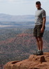
Devil's Canyon is just about prime season from now until late June. You might be naming your first born Tyler, Poncho or even Fritzski after this doosey :o

Upper Woods Canyon is prime season throughout June! (My personal ALL time favorite!)

Lizard keys up the ultimate multiday trip
Wet Beaver Canyon Loop

Hiking a mountain is cool, hiking the Superstition Ridgeline is awesome, the Grand Canyon is "grand"...
but the trips above will leave you thinking LIFE IS SO FRICKEN AWESOME for WEEKS on end!
I highly recommend! :)
- joe
contribute to this member driven resource
ie: RS > Save/Share after hikes Route Scout GPS Topo Mapper on the App Store Route Scout GPS Topo Mapper on Google Play
User avatar
joebartels
Guides: 264 | Official Routes: 226
Triplogs Last: 6 d | RS: 1960
Water Reports 1Y: 14 | Last: 8 d
Joined: Nov 20 1996 12:00 pm

Post by joebartels »

I seriously don't see a Rav, Swift and such making it

it's not the type of thing you can back out of like Tortilla TH, further more if you're under powered you'll seriously screw up your transmission getting out, clearance is also a must

sounds like Billy is set

S-10 maybe, if I say no I'm sure it'll happen :lol:
- joe
contribute to this member driven resource
ie: RS > Save/Share after hikes Route Scout GPS Topo Mapper on the App Store Route Scout GPS Topo Mapper on Google Play
User avatar
mjmann
Triplogs Last: 8,156 d | RS: 0
Water Reports 1Y: 0 | Last: never
Joined: Apr 14 2002 6:37 am
City, State: Chandler, AZ

Post by mjmann »

Joe,

That's what my concern is too. Yeah maybe a 4X4 can (or is supposed to) go anywhere...regardless of the driver...but I've seen some spots where I wouldn't even take a chance. You get jammed up out there...your basically screwed. I'd rather not risk it if you think it'd be too much of a hassle.

Hey Billy...what do you think...some other weekend???...Maybe Joe will put something together for everyone???. :wink:

M-
contribute to this member driven resource
ie: RS > Save/Share after hikes Route Scout GPS Topo Mapper on the App Store Route Scout GPS Topo Mapper on Google Play
User avatar
joebartels
Guides: 264 | Official Routes: 226
Triplogs Last: 6 d | RS: 1960
Water Reports 1Y: 14 | Last: 8 d
Joined: Nov 20 1996 12:00 pm

Post by joebartels »

Hey you guys throw it together I'm game :)

I don't mind going back a couple times
- joe
contribute to this member driven resource
ie: RS > Save/Share after hikes Route Scout GPS Topo Mapper on the App Store Route Scout GPS Topo Mapper on Google Play
User avatar
AK
Triplogs Last: 7,393 d | RS: 0
Water Reports 1Y: 0 | Last: never
Joined: Mar 06 2003 2:49 am
City, State: Mesa, AZ

Post by AK »

I'd like to tag along! Someone just give the word, time and place. I don't have a 4x4, but have a friend thats type rated in UH-60 Blackhawks! Think that will get us there? :lol:
Aaron
Aaron

"Can't think of a good signature quote" - Me
contribute to this member driven resource
ie: RS > Save/Share after hikes Route Scout GPS Topo Mapper on the App Store Route Scout GPS Topo Mapper on Google Play
User avatar
Billy
Triplogs Last: 8,128 d | RS: 0
Water Reports 1Y: 0 | Last: never
Joined: Nov 01 2002 7:17 am
City, State: Mesa, AZ

Prime Time Canyoneering!

Post by Billy »

Hey Billy...what do you think...some other weekend???...Maybe Joe will put something together for everyone???.
mjmann Marty
Hey you guys throw it together I'm game joe bartels

I'd like to tag along! Someone just give the word, time and place. I don't have a 4x4, but have a friend thats type rated in UH-60 Blackhawks! Think that will get us there?
Aaron
AK
I too would love to go on a trip like this (especially if it meant I got to learn how to rappel). I am going on the hellsgate trip this weekend and so would not be able to attend but if you decide to do this trip another weekend I would be all for it.matt gilbert

Anytime you guys want to go for that adventure or any others, just let me know. I can only have use of the truck or jeep every other weekend, my personal vehicle is an Isuzu Trooper 4x4. I'm anxious to get out and do something challenging. I'm up for camping too, but can only go camping when my camping partner is in town :-) Let's keep in contact and make something happen soon. Looking forward to some great times.
contribute to this member driven resource
ie: RS > Save/Share after hikes Route Scout GPS Topo Mapper on the App Store Route Scout GPS Topo Mapper on Google Play
User avatar
AK
Triplogs Last: 7,393 d | RS: 0
Water Reports 1Y: 0 | Last: never
Joined: Mar 06 2003 2:49 am
City, State: Mesa, AZ

Post by AK »

Well I'll tell you what. I've never been there before. So If one of the people that have been there before can come up with something, I'm in. I'm just not comfortable planning and going to a tecnically challenging place like that without somone with a little experience. I think Joe would make an excelent guide on a venture like this. Sorry Joe. :roll:
AK
Aaron

"Can't think of a good signature quote" - Me
contribute to this member driven resource
ie: RS > Save/Share after hikes Route Scout GPS Topo Mapper on the App Store Route Scout GPS Topo Mapper on Google Play
User avatar
Billy
Triplogs Last: 8,128 d | RS: 0
Water Reports 1Y: 0 | Last: never
Joined: Nov 01 2002 7:17 am
City, State: Mesa, AZ

Prime time Canyoneering!

Post by Billy »

I agree with you Aaron............JOE needs to lead the group, he doesn't seem to have a problem with that (thank you Joe :), thank you JOE :sweat: ), so when he is up to it...........he'll just have to let the rest of us know.
contribute to this member driven resource
ie: RS > Save/Share after hikes Route Scout GPS Topo Mapper on the App Store Route Scout GPS Topo Mapper on Google Play
User avatar
mjmann
Triplogs Last: 8,156 d | RS: 0
Water Reports 1Y: 0 | Last: never
Joined: Apr 14 2002 6:37 am
City, State: Chandler, AZ

Post by mjmann »

...and I agree with Billy! If Joe would be willing to take a bunch of us on the Devil's Canyon hike, act as a guide if you will, :D ...then we should set a date that is mutually agreeabale to those interested.

Like Matt I'm unavailable this weekend as I'm hiking up in Sedona...but should be able to in a few weeks.

All those in favor of Joe as the "Official Guide"...say AYE!!! :sweat:

Marty
contribute to this member driven resource
ie: RS > Save/Share after hikes Route Scout GPS Topo Mapper on the App Store Route Scout GPS Topo Mapper on Google Play
User avatar
Kenny
Triplogs Last: 5,054 d | RS: 0
Water Reports 1Y: 0 | Last: never
Joined: Apr 09 2003 9:02 am
City, State: Mesa, AZ
Contact:

Post by Kenny »

You can count on my two boots ... or teva's as the case may be. :D And I will drive as far as my CR-V will take me. Hike/swimArizona is ok with me!
Sundays are better. but in a few weeks Saturdays are good.

i'm in! :D

Kenny
contribute to this member driven resource
ie: RS > Save/Share after hikes Route Scout GPS Topo Mapper on the App Store Route Scout GPS Topo Mapper on Google Play
User avatar
jimserio
Triplogs Last: 8,155 d | RS: 0
Water Reports 1Y: 0 | Last: never
Joined: Feb 06 2002 12:54 pm
City, State: Tempe, AZ

Post by jimserio »

I've got a Jeep Cherokee that I've been dying to take off-roading (finally did Crown King last weekend). We can comfortably cram 4 of us plus gear in there. I think a few others here have Jeep's as well.
contribute to this member driven resource
ie: RS > Save/Share after hikes Route Scout GPS Topo Mapper on the App Store Route Scout GPS Topo Mapper on Google Play
User avatar
azhiker96
Triplogs Last: 947 d | RS: 2
Water Reports 1Y: 0 | Last: never
Joined: Feb 03 2002 10:17 am
City, State: Gilbert, AZ

Post by azhiker96 »

I have a Grand Cherokee that should be able to make the trailhead. I'd like to hit this either June 7th, 21, or 28th. I'll be in Oregon the weekend of the 14th.
contribute to this member driven resource
ie: RS > Save/Share after hikes Route Scout GPS Topo Mapper on the App Store Route Scout GPS Topo Mapper on Google Play
User avatar
AK
Triplogs Last: 7,393 d | RS: 0
Water Reports 1Y: 0 | Last: never
Joined: Mar 06 2003 2:49 am
City, State: Mesa, AZ

Post by AK »

I've got a honda civic. looks like like i'm riding with someone with a 4x4, if that someone doesn't mind. Billy has a good set of dates that i'm available for. Looks like Joe has been voted in as our guide. :wink: Hopefully he will.

Aaron
Aaron

"Can't think of a good signature quote" - Me
contribute to this member driven resource
ie: RS > Save/Share after hikes Route Scout GPS Topo Mapper on the App Store Route Scout GPS Topo Mapper on Google Play
User avatar
MaryPhyl
Triplogs Last: 9,113 d | RS: 0
Water Reports 1Y: 0 | Last: never
Joined: Apr 29 2002 7:58 am
City, State: Flagstaff, AZ

Post by MaryPhyl »

I just went and read all the HAZ info on Devil's Canyon--that was fun!! MP
contribute to this member driven resource
ie: RS > Save/Share after hikes Route Scout GPS Topo Mapper on the App Store Route Scout GPS Topo Mapper on Google Play
User avatar
azrocks
Triplogs Last: none | RS: 0
Water Reports 1Y: 0 | Last: never
Joined: Mar 21 2002 5:38 pm

Post by azrocks »

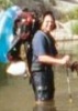
Please be careful. This is not a beginner canyon, and I don't believe it is
safe to jump unless someone has been down first to check for depth,
submerged waterlogged trees etc. The longest drop is 70 ft or more,
so you would hit the water at 50 mph. You can't belly flop at that speed,
you have to enter the water just right or you could break your neck.
Start canyoneering with Agua Fria, Fish Creek, upper West Fork of Oak
Creek, Wet Beaver Creek, upper West Clear Creek, Salome, Pumphouse
Wash, Buckskin Gulch. That's already plenty risky and too much fun, and
will spoil you for regular hiking.
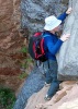
Get proper training in rapelling, prussiking and setting anchors before
tackling Lower Devil's, and go with someone experienced.
contribute to this member driven resource
ie: RS > Save/Share after hikes Route Scout GPS Topo Mapper on the App Store Route Scout GPS Topo Mapper on Google Play
User avatar
azhiker96
Triplogs Last: 947 d | RS: 2
Water Reports 1Y: 0 | Last: never
Joined: Feb 03 2002 10:17 am
City, State: Gilbert, AZ

Post by azhiker96 »

Sound advice AZROCKS! When I read the trail description I was surprised they found ropes left attached to the anchors. I am glad nobody used those ropes. Who knows how long they've been out in the elements? I only trust anchors I've set or inspected and ropes where I know it's history or know and trust the owner.
contribute to this member driven resource
ie: RS > Save/Share after hikes Route Scout GPS Topo Mapper on the App Store Route Scout GPS Topo Mapper on Google Play
User avatar
AK
Triplogs Last: 7,393 d | RS: 0
Water Reports 1Y: 0 | Last: never
Joined: Mar 06 2003 2:49 am
City, State: Mesa, AZ

Post by AK »

Thanks for the advice guys. Maybe i'll wait til i'm a little more in the groove.
Aaron
Aaron

"Can't think of a good signature quote" - Me
contribute to this member driven resource
ie: RS > Save/Share after hikes Route Scout GPS Topo Mapper on the App Store Route Scout GPS Topo Mapper on Google Play
User avatar
Billy
Triplogs Last: 8,128 d | RS: 0
Water Reports 1Y: 0 | Last: never
Joined: Nov 01 2002 7:17 am
City, State: Mesa, AZ

Prime Time Canyoneering

Post by Billy »

For anyone who might be interested in getting certified in belay, the Multi Generational Center, located East of Power Road on Adobe is offering 45 minute classes to teach belay. Cost is $5.00 for the class. Equipment is provided and shoes can be rented.

Billy :-)
contribute to this member driven resource
ie: RS > Save/Share after hikes Route Scout GPS Topo Mapper on the App Store Route Scout GPS Topo Mapper on Google Play
Post Reply

Return to “Trail Chat”