| | -
| 2 labels | 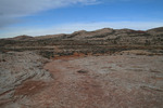 |
|
|
-
-
-
| |  |
|
1 |
-
| |  |
|
2 |
-
-
-
| 1 label | 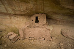 |
|
|
-
| 1 label | 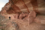 |
|
|
-
-
-
| 1 label | 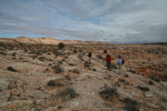 |
|
1 |
-
-
|
| | |
|
| Hiking | 3.00 Miles |
200 AEG |
| | Hiking | 3.00 Miles | 3 Hrs | | 1.00 mph |
| 200 ft AEG | | | | |
|
|
| |
| Linked |
|
none
[ show ]
| no linked trail guides |
| Partners |
|
[ show ]
| partners | | Butler Wash Ruins, UT
Here's another set of Butler Wash Ruins accessed from US-163 just east of the cut through Comb Ridge between mile markers 40 and 41. You pass through a cattle gate, and head north on CR262 (aka Butler Wash Road) about 1.5 miles where you come to a cattle guard and kiosk. Note a 4WD double track heading west along the cattle fence towards Comb Ridge and Butler Wash. The double track will end on an expanse of slick rock that will serve as the TH parking lot (The GPS Coordinates for the parking area are: 37 16.561N; 109 38.728W; at an elevation of 4,452 feet). As you walk up to canyon, note the ruins directly in front of you on the west side of Butler Wash.
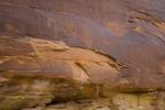
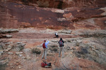
As you stand near the canyon edge you'll see cairns to your left (south), across the slick rock. Follow the cairns until you see an area that is trending downwards toward a large split rock near the cliff face. You squeeze down through that split and proceed down to an alcove along the east side. The rock art (Wolfman Panel) is just beyond that alcove. There are only narrow ledges, so if you want to get up close, be careful. There is a reason it is called slick rock. You can get a good idea of the scope of the panel from below, but a close-up view is informative as well. There are always little images that aren't always visible from farther away. Follow the footpaths down to Butler Wash and up to the ruins on the west side.
After our visit to the Wolfman Panel site, we parked on the south side of US163 and followed the slickrock between Butler Wash and Comb Ridge towards the San Juan River. We didn't encounter any obvious sites along this section, although many maps show a cliff dwelling at the confluence of Comb Wash and the San Juan River... 
PS. Needed to reach back in the memory banks to a 2008 trek [ photoset ]  |
| _____________________
| | |
|
|
|
|
|
| |
 Route Editor


