| | -
-
| 1 label | 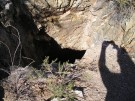 |
|
|
-
-
-
|
| | |
|
| Hiking | 4.90 Miles |
800 AEG |
| | Hiking | 4.90 Miles | 2 Hrs 20 Mns | | 2.10 mph |
| 800 ft AEG | | | | |
|
|
| |
| Linked |
|
none
[ show ]
| no linked trail guides |
| Partners |
|
none
[ show ]
| no partners | | | This was a hot hike starting at 11AM in mid-May but not altogether that challenging. The initial ascent is not difficult and proves to be the most daunting of the loop. After catching my breath from this climb I noticed the abandoned mine shaft just to the left of the main trail. The State of Arizona has put up a sign warning of the lethal dangers of exploring mines like these. Apparently there are quite a few other mine shafts in this area but this seemed to be the only on directly adjacent to the trail. There were quite a few small lizards and rabbits and I spotted a cactus wren feeding a hole full of peeping chicks about twelve feet up a giant saguaro. I liked this trail because it is an easy afternoon hike without a lot of switch-backs. The Go John Loop took me less than two and a half hours total with only a couple brief stops for rest and food. |
| _____________________
"Being unselfish is a natural high, like hiking or paint thinner."
- Homer J Simpson |
| | |
|
|
|
|
|
| |
 Route Editor


