| | -
| 1 label | 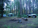 |
|
|
-
-
| |  |
|
2 |
-
| |  |
|
4 |
-
| 2 labels | 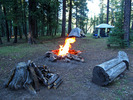 |
|
2 |
-
-
-
| 1 label |  |
|
1 |
|
| | |
|
| Car Camping | |
|
| | Car Camping | | 6 Days | | |
| | | |
| |
| Partners |
|
none
[ show ]
| no partners | | It was past time for me to plan another car camping/hiking/R&R "get-away". This time to one of my favorite Mogollon Rim-Cabin Loop area locations at 7435ft elevation.
Back in early June I had intended this July 13 to July 18 (5nt/6day) event to be a group outing, but due to Coconino NF fire restrictions in-force prior-to 7/12/11 and my concerns regarding a possible Coconino NF violation of group/vehicle camping at this proposed campsite without me having a Plan "B" group campsite location, on 7/9 I most reluctantly thought it best to cancel our previously planned group overnight camping.
On my Mogollon Rim arrival day Wed-7/13 I drove the immediate area up/down/around FR139 and FR139C and just could not find an alternate campsite location that I liked enough to commit set up of my major "Camp Grasshopper" for 5 nights and 6 days of camping and that was also within close hiking access to our Cabin Loop area trails. So I ended up camping for this entire period at my original planned group campsite with "off trail" hiking access to all the areas that I had originally intended to explore:
Thurs-7/14: From my campsite to ~3mls up FR139C to off trail down 300ft to intersection of U-Bar Tr28/Barbershop Canyon to off trail ~4.5mls up Barbershop Cy to an off trail exit point back to my campsite location;
Fri-7/15: From my campsite to cross FR139C to off trail over to Merritt Draw to explore the Forest Service protected (fenced) riparian area in this interesting draw with its incredibly lush green meadow area;
Sat-7/16: Dane Canyon Loop (7.0 mile route per hike description write-up) from the FR321A Dane Spring/Cabin TH Start location;
Sun-7/17: From my campsite up FR139C to connect with an obscure, closed to vehicles logging road (FR9735P) to off trail downhill to intersect middle Merritt Draw with plans to explore a few hiking miles down riparian Merritt Draw to its intersection end at U-Bar Tr28/Barbershop Canyon and then hike back up Merritt Draw past my previous Merritt Draw entry point and hike all the way up Merritt Draw to repeat the hiking area of my 7/15 hike;
I will post separate photosets and GPS Tracks for these above four hikes and will also post a few "Camp Grasshopper" pics from my very enjoyable 5nts/6days  |
| _____________________
| (Outside.. "there is No Place Like It!!") |
| | |
|
|
|
|
|
| |
 Route Editor


