| | -
-
-
-
-
-
| 1 label |  |
|
|
-
| 1 label | 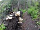 |
|
|
-
-
-
-
-
-
-
-
|
| | |
|
| Hiking | 6.50 Miles |
1,797 AEG |
| | Hiking | 6.50 Miles | 4 Hrs | | 1.63 mph |
| 1,797 ft AEG | | 15 LBS Pack | | |
|
|
| |
| Linked |
|
none
[ show ]
| no linked trail guides |
| Partners |
|
none
[ show ]
| no partners | | | I hiked this trail with a group on Meetup.com named "Arizona Desert Hikers". They were very easy going and a great group to hike with. The top of Mount Lemon was covered with clouds as we drove up the 20+ miles from Tucson. We parked vehicles at both ends of the trail so we could shuttle and hike one way. Temperature was in the mid 60s and near 100% humidity in the clouds. We came across many creeks with running water and several waterfalls. We also located the airplane wreckage. The second half of the hike up and out was a bit harder than I had anticipated but was worth it. We hiked in and out of the clouds and visibility varied from 50 yards to clear. Over all I would recommend this hike during the Monsoon season but make sure to bring your poncho. After our hike we drove about 5 miles up the mountain to Summer Haven and had lunch. |
|
Wildflowers Observation Substantial
|
|
| _____________________
| Living must be a daring adventure or nothing at all. |
| | |
|
|
|
|
|
| |
 Route Editor


