DESTINATION Generic 33 Photosets
| | -
| |  |
|
1 |
-
-
-
-
-
-
-
|
| | |
|
| Hiking | 8.32 Miles |
2,682 AEG |
| | Hiking | 8.32 Miles | | | |
| 2,682 ft AEG | | | | |
|
|
| |
| Linked |
|
none
[ show ]
| no linked trail guides |
| Partners |
|
none
[ show ]
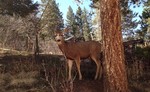
| no partners | | | Nice day for a hike. Saw 7 people up and a group of 10 with dogs around 5 pm that we're going the opposite direction. No packs water bottles and no where near any trail heads. Hit peak proper of Mt. Esther, but ring the peak had a lot of snow. Much more than anticipated. The plan was an out and back going down the notch and back up. Got to the notch and there was over a foot of snow down the trail as far as I could see so I turned around and made a loop. Found and followed several old faint trails that don't appear on local maps and found a stand of aspens I want to hit up in the fall. All in all nice weather 50's maybe 60's in the sun, but everything is relative and that's shorts weather here! I've been so busy riding the last 3 months, I forgot how lucky I am to have great hiking options out my front door. I would like to see some of the snow go away on ring the peak. A little surprised to see entire Crystal Creek reservoir completely covered in snow and frozen. |
| _____________________
| | |
|
|
|
|
|
| |
 Route Editor


