| | -
-
-
| |  |
|
5 |
-
-
-
|
| | |
|
| Hiking | 6.62 Miles |
1,132 AEG |
| | Hiking | 6.62 Miles | 3 Hrs 11 Mns | | 2.08 mph |
| 1,132 ft AEG | | | | |
|
|
| |
| Linked |
|
none
[ show ]
| no linked trail guides |
| Partners |
|
none
[ show ]
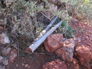
| no partners | | I hiked in this area yesterday and got stuck in the rain. This time I searched the cliffs in the opposite direction. I started off following the Dutchman trail and then turning off where the old mining road turns east. Yes the Dutchman trail from First Water TH follows and/or parallels an old mining road for about 1.5 miles. Yesterday I found the remains of a small bridge across the wash. Today I hiked up toward the butte above the old Hickey draw mine and found a more recent mine/hole being dug. I had seen red tailings on the hill and decided to take a look. The hole is small and when I dropped down in to have a look I wasn't sure I could bend enough to get inside so I bailed. When I tried to climb out the hole was too small to bend my knees so I had to climb out on arm power. I need to bring a skinny guy up to get a look inside.  I skirted the cliff to the east looking for a rumored cave but no luck. On the way out I got passed by some backpackers while I was getting food out of my pack. I didn't want to follow them in so I turned off on the old trail alignment and scrambled up to the current trail. The short cut put me 100 yards ahead of them and I was out of there. I skirted the cliff to the east looking for a rumored cave but no luck. On the way out I got passed by some backpackers while I was getting food out of my pack. I didn't want to follow them in so I turned off on the old trail alignment and scrambled up to the current trail. The short cut put me 100 yards ahead of them and I was out of there.  |
| _____________________
| | |
|
|
|
|
|
| |
 Route Editor


