| | -
-
-
| |  |
|
2 |
-
-
-
-
-
-
-
-
-
-
-
| |  |
|
2 |
-
|
| | |
|
| Hiking | 4.00 Miles |
400 AEG |
| | Hiking | 4.00 Miles | 4 Hrs 20 Mns | | 1.71 mph |
| 400 ft AEG | 2 Hrs Break | 5 LBS Pack | | |
|
|
| |
| Linked |
|
none
[ show ]
| no linked trail guides |
| Partners |
|
none
[ show ]
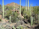
| no partners | | Nice hike! I and my hiking buddy Linda (not listed here yet) started out at about 9:30 a.m. on a really perfect day-- just cool enough for a jacket in the morning, just sunny enough not to need it on the way back, and with a light breeze that increased during the day. We took the King Canyon trail from just a bit down from the entrance to the AZ-Sonoran Desert Museum, hiked it on a slight to near-moderate rise to where the trail drops a bit and you meet with the Sendero Esperanza trail and bear left past a slightly creepy stone building whose door has been bashed in towards the Mile Wide and Gould mine ruins. We did quite a few detours to take photos, eat lunch at the Mam-A-Gah Picnic Area, talk to fellow hikers, check out interesting rocks (there's some GREAT strata out there! Tucson geology is brain-breakingly crazy) and just dither around in general.
A bit of clarification against previously-posted directions: The Mile-Wide Mine ruins are, to the naked eye, just a wash of gray mine-tailings high up on a hillside that has a single volcanic extrusion poking through to the trail's right; binoculars show a possible mine-entrance, but I wouldn't want to hike up to it-- it's quite a rough climb. On the other hand, the trail up to the Gould Mine (variously called the "Gouda Cheese Mine" and the "Gou'ald Mine" (in which we expected to find alien snakes)) is narrow at first but widens out gradually as you approach a stone powder-house that was partially carved from the bedrock; it's roofless but otherwise intact and doesn't have the oddly creepy feel of the earlier building, which produced fuzzy and orb-filled photos. The Gould Mine itself mostly consists of a 300-foot-plus-deep shaft with a very sturdy grating securely fastened over it and a decent fence, along with tailings, old timbers and a few hillside excavations-- not a lot of excitement there, but interesting.
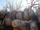
At this point we turned around, backtracked down to the intersection of the King Canyon and Sendero Esperanza trails to get a look at the petroglyphs. As this is something of a huge interest of mine, I was quite excited. They can be found on either side of the wash below the dam, but the best ones seem to be high up to the right; you have to do a bit of fairly hazardous cliff-walking to get a really good look, but it's worth it so long as you've *very* careful (a fall would certainly break bones and might be fatal.) The glyphs themselves range from rather faint to pretty clear, and there's a particularly beautiful one that's most likely a representation of an Agave.
Afterwards we backtracked the way we had come in; there looked to be some pretty high ledges of bedrock across the wash and we weren't inclined at that point to hazard them as we're both quite short. All in all, this was a very worthwhile hike; we saw a herd of eight muledeer on the way back plus a few hawks and ravens, got some excellent photos, a decent workout for the legs and ate lunch in a really beautiful place. |
|
Wildflowers Observation Isolated
Notch-leaved Phacelia nearly a month early, isolated but very evident. |
|
| _____________________
| | |
|
|
|
|
|
| |
 Route Editor


