| | -
-
-
| |  |
|
2 |
-
-
-
-
-
| 1 label | 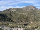 |
|
|
-
|
| | |
|
| Hiking | 11.68 Miles |
3,100 AEG |
| | Hiking | 11.68 Miles | 6 Hrs 30 Mns | | 1.80 mph |
| 3,100 ft AEG | | | | |
|
|
| |
| Partners |
|
[ show ]
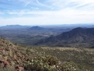
| partners | | Now I know why there's only one other triplog for this hike. Son of a !@* - we had an interesting day of exploring with exhilaration, frustration, and achy muscles.
Not surprisingly the first 2.4 miles of trails are easy to follow that are in the Spur Cross Recreational area. At the right turn leaving Elephant Mountain trail crossing the county park boundary with permit, the trail is harder to follow in places and is almost entirely loose medium/large rocks. Making for more excitement is all the grass from recent rains disguising the trail in areas. Thank goodness for the cairns, and we rebuilt some at the second wash crossing where we made a wrong turn. (At 2994 feet and 33.90236, -111.98316, go right to head out of the wash.)
The fence at 3.4 miles (33.9047, -111.98441)in the hike description has lost it's upper barbwire and there's nothing to go under anymore - just through. Follow the cairns where the trail seems lost in a sea of similar rocks covered in grass. In general, you are following along close to the fence. We lost the cairns at 3499 feet (33.91306, -111.98118), and without GPS we'd still be sitting up there right now.
In the final ascent to the summit, I didn't go far enough to the west before starting the climb. I realized this when I got to a ledge that I couldn't get past that was about 30 feet from the top. In the process of trying to get around it, a boulder moved and scared the crap out of me  and I headed straight back down. It was too late in the day, and my legs and adrenal glands weren't up for a reattempt. and I headed straight back down. It was too late in the day, and my legs and adrenal glands weren't up for a reattempt.
All in all the views were fantastic and the weather really was great. Afterwards it was only chewing and no talking during our dinner feast at El Encanto. |
| _____________________
| | |
|
|
|
|
|
| |
 Route Editor


