| | -
-
| 1 label | 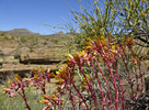 |
|
|
-
| 1 label | 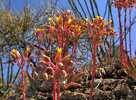 |
|
|
-
| 1 label | 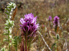 |
|
|
-
| 1 label | 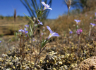 |
|
2 |
-
| 1 label | 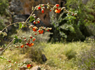 |
|
|
-
|
| | |
|
| Hiking | 0.50 Miles |
50 AEG |
| | Hiking | 0.50 Miles | 30 Mns | | 1.00 mph |
| 50 ft AEG | | | | |
|
|
| |
| Linked |
|
none
[ show ]
| no linked trail guides |
| Partners |
|
none
[ show ]
| no partners | | Headed in intending to check out portions of the upper canyon. I parked and locked into my planned route. It didn't take long to figure out this wasn't going to be easy with an approximate 70 foot drop. I worked across a dangerous slope of scree.
Dudleya was busting out all over the place. I've seen a sprig or two in the past but nothing like this. One slope was covered in various dried mesh. Some was wild cucumber and some I couldn't make out.
It wasn't difficult finding a way down but I decided I'd seen the best views from above. Decided I'd rather checkout other areas. The most stunning sight of the day was water is STILL going over the bridge at Tortilla Flats. It's barely flowing, still amazing as it hasn't rained in months! |
|
Wildflowers Observation Moderate
|
|
| _____________________
| | |
|
|
|
|
|
| |
 Route Editor


