| | -
-
| |  |
|
1 |
-
-
|
| | |
|
| Hiking | 14.60 Miles |
2,472 AEG |
| | Hiking | 14.60 Miles | 9 Hrs 5 Mns | | 1.86 mph |
| 2,472 ft AEG | 1 Hour 13 Mns Break | | | |
|
|
| |
| Linked |
|
none
[ show ]
| no linked trail guides |
| Partners |
|
[ show ]
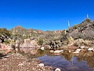
| partners | | Last time I hiked in this area was in March 2020 and there was a lot of fire damage (not a lot of plants and trail wash out). Things have grown in nicely. The catclaw increased at about 1.5 miles out. That slowed us down.
The path to the cave was worn in plus the cairns made the route finding on the climb up not so bad. We lost the path on the way down, but not really an issue with careful steps.
We boulder hopped the creek on the exit (to whiskey spring) for a less brushy, overgrown path and we’re rewarded with lots of small waterfalls/cascades. There was lots of water along the whole hike too - would be a perfect time for people to backpack through here. |
| | |
|
|
|
|
|
| |
 Route Editor


