DESTINATION Sycamore Point Bike Trail #131 1 Photoset
2024-08-14 | | -
| 1 label |  |
|
|
-
| 1 label | 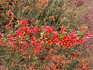 |
|
|
-
| 1 label | 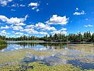 |
|
|
-
| 1 label |  |
|
|
-
-
| 1 label | 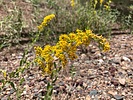 |
|
|
-
-
| 1 label | 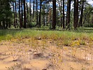 |
|
|
-
| 1 label | 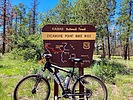 |
|
|
-
| 1 label | 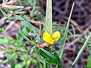 |
|
|
-
| 1 label | 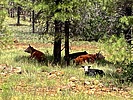 |
|
|
-
| 1 label |  |
|
|
-
-
| 1 label | 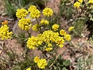 |
|
|
-
| 3 labels | 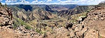 |
|
|
|
| | |
|
| Biking - Mtn | 9.91 Miles |
228 AEG |
| | Biking - Mtn | 9.91 Miles | 1 Hour 4 Mns | | 9.29 mph |
| 228 ft AEG | | | | |
|
|
| |
| Linked |
|
none
[ show ]
| no linked trail guides |
| Partners |
|
none
[ show ]
| no partners | | My plan was to ride about nine miles from White Horse Lake to Sycamore Point — where I intended to meet my wife and enjoy a romantic, scenic, picnic. Then ride back. As long as the roads were decent, I could do 20 miles.
Hoping to hit the trail by 9:30 a.m., my wife & I left Phoenix earlier than normal. After various stops along the 3+ hour drive from Phoenix, I rolled out 50 minutes late.
From the free day-use parking, I followed a near-shore dirt path to the east end of the lake. I was expecting to ride between car-blocking boulders up on to FR 12, but my way was barred by a barbed-wire fence and locked gate. After heaving my bike over the fence, I started riding down FR 12. Just past the east end of the fence is a pullout. I’d use that as a trailhead instead. Save yourself the heaving.
FR 12 and FR 110 are wide and smooth ... for driving. Not so much for bikes. I mean, it wasn't bad, but the gravel "slush" between tire tracks, or on the berm, did cause concern when being passed by vehicles. (Six in nine miles.)
The only critters I saw were a small herd of cattle, and one deer that crossed the road barely in range of my GoPro. (Because I use the wide-angle setting, objects in the middle of the frame appear further away.)
I biked the four up & down miles of FR 12, non-stop, in only 33 minutes. Seemed longer. There were no big “climbs”. Even though I rode at a good pace, I could feel the 6,600 ft. elevation. (Exactly a mile higher than my house in Sunnyslope.)
At the Trail #131 "trailhead", I stopped, waiting for my wife, who arrived a few minutes later. I had made a strip map for her, but wanted to make sure she made the correct turn. Besides our picnic, meeting her at the scenic vista would allow me to top off my water.
Trail #131 descends a fast 150 ft. in ¾ mile. I had to mind the slush, lest I do another painful Bean Peaks.
Trail #131 levelled out for a ½ mile, made another short descent, then eased imperceptibly down the remaining miles to the scenic vista.
Though a mile longer than FR 12, I completed Trail #131 quicker, in only 31 minutes. There are no facilities — not even a picnic table — overlooking Sycamore Canyon. I’m sure that’s why there’s no camping or fires allowed within a quarter mile. The views are incredible: Mingus & Woodchute were visible 23 miles southeast.
My wife & I finished our picnic at 12:30. Riding back uphill to White Horse Lake would have taken longer, especially stopping for photos. I could have done it, but we probably wouldn’t have gotten home until 7:00 p.m. Instead, we drove back from Sycamore Point together. So, yeah, I basically drove seven hours for a one hour ride. 
5* rating is less about the pleasant enough ride, and ALL about the payoff at the end.
Rumble Video: https://rumble.com/v5bjm3o-biking-white ... point.html
Vimeo Video: https://vimeo.com/1000372612 |
|
Wildflowers Observation Isolated
Besides pictured species, also spotted wandbloom penstemon and Wheeler's thistle. |
|
| _____________________
| http://prestonm.com : Everyone's enjoyment of the outdoors is different and should be equally honored. |
| | |
|
|
|
|
|
| |
 Route Editor


