| |
| General Crook Trail V51-V57, AZ | | -
| 2 labels |  |
|
|
-
| 1 label | 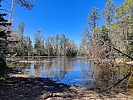 |
|
|
-
-
| 1 label | 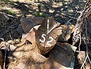 |
|
|
-
| 1 label | 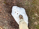 |
|
|
-
| 1 label | 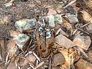 |
|
|
-
| 1 label | 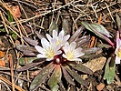 |
|
|
-
| 1 label |  |
|
|
-
| 1 label | 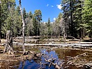 |
|
|
-
| 1 label | 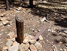 |
|
|
-
| 1 label | 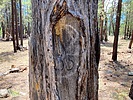 |
|
|
-
| 2 labels | 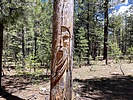 |
|
|
-
| 1 label | 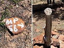 |
|
|
-
| 1 label | 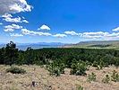 |
|
|
-
|
| | General Crook Trail V51-V57, AZ | | | |
|
|
General Crook Trail V51-V57, AZ
| | |
|
| Hiking | 9.46 Miles |
744 AEG |
| | Hiking | 9.46 Miles | 4 Hrs 3 Mns | | 2.34 mph |
| 744 ft AEG | | | | |
|
|
| |
| Partners |
|
none
[ show ]
| no partners | | Rim Road has a project going on. Currently from miles 36-40. Runs through October. On a low traffic mid-week before Memorial Day, the delay was 15 minutes. I started searching for V51 at 9:35 a.m. After 30 minutes (red on the attached route), I was unsuccesful. All I found was the happy face balloon. I found four more balloons before my day was done. 
AZ Conservation Corps had a crew working the next 1¼ miles. Their work is much appreciated, but the chevrons were mostly easy to follow. V52 was right where I expected.
I saw many small patches of snow. The overnight low was around 32℉, but hike temps were perfect.
I foundr V53 about 250 ft. west of where it was previously mapped. The trail crosses FR 295 at Rim Road. Walking out of the woods, I startled a group of eight dirt bikers. Friendly guys, but they were headed 175 miles up to Page! 
I followed Rim Road for a bit, until I found a chevron whereupon I re-entered the treeline. V54 was where I expected.
I didn’t see a chevron marking where to turn off FR 752, nor for the next 200 yds., so you’ll want to download a GPS route. The trail then switchbacks down to Lake #4, which was wet for the first time I can remember. Climbing up from the lake, V55 is 300 ft. west of where I expected. I’ve been by V55 before, and hadn’t noticed, so it was quite a surprise to turn around see a "V55" also carved in a tree! I assume it’s an original etching since it was a tall dead tree, with the snapped off upper half laying across the trail. 
From the Jesus Tree -- or was it Moses? -- I got back on Rim Road. After passing the Sitgreaves sign, I dropped off the road, picking the trail back. I found the V56 arrow rock in the middle of the trail. The post is maybe 20 ft. off the trail, about 300 ft. west of its prior indicated location.
After crossing an anonymous dry lake, the trail gets a bit confusing. I accidentally wandered off trail. Up a draw, I found a tree with a chevron, following the trail back to where I lost it. (This sort of wandering accounts for the extra three miles I hiked.) The chevroned singletrack trail — not old road bed — paralleled Rim Road eighty feet below.
As I was looking for V57, an oddity occured: I could see a chevron downslope, next to the road, but the trail, also with chevrons, continued following the contour. I stayed on trail, moving slowly. I never saw anything related to V57 actually on the General Crook Trail. Completing the segment at FR 115, I doubled back down Rim Road: After searching V57's indicated location for 20 minutes, I gave up.
Rumble Video: https://rumble.com/v4uom5h-hiking-gener ... 1-v57.html
Vimeo Video: https://vimeo.com/945491814 |
|
Wildflowers Observation Isolated
|
|
| _____________________
| http://prestonm.com : Everyone's enjoyment of the outdoors is different and should be equally honored. |
| | |
|
|
|
|
|
| |
 Route Editor


