| |
| General Crook Trail V71-V80, AZ | | -
-
-
| 1 label |  |
|
|
-
| 1 label |  |
|
|
-
-
| 1 label | 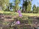 |
|
|
-
| 1 label |  |
|
|
-
| |  |
|
1 |
-
| 1 label |  |
|
|
-
| 1 label |  |
|
|
-
| 1 label |  |
|
|
-
| 2 labels |  |
|
|
-
| 1 label |  |
|
1 |
-
| 1 label |  |
|
|
-
| 1 label |  |
|
|
|
| | General Crook Trail V71-V80, AZ | | | |
|
|
General Crook Trail V71-V80, AZ
| | |
|
| Hiking | 10.86 Miles |
524 AEG |
| | Hiking | 10.86 Miles | 2 Hrs 40 Mns | | 4.07 mph |
| 524 ft AEG | | | | |
|
|
| |
| Linked |
|
none
[ show ]
| no linked trail guides |
| Partners |
|
none
[ show ]
| no partners | | I started out mountain biking, but I hiked probably half of it. I dunno what you call a combination of biking and hiking?
V80-V71 ended up being more difficult than V62-V71 would have been to bike. I intended to make it an out & back, but the out took as long as I budgeted for the whole thing. It would be easy to hike.
The dirt road through Forest Lakes was great. I had to walk up one steep & rocky section. Then I had to walk back a half mile because I had lost my GPS. 
I thought the trail continued along the road to Horse Trap TH: Instead, it angles left, crossing the powerlines. I rode across the powerline prairie. V76 was just inside the west treeline.
The 1⅓ miles to V75 crossed a brushy draw, a small creek, and up the rocky opposite slope. I walked most of it. That distance between markers may have been more than a mile, but V75 is almost exactly five miles from V80. Maybe V76 got shifted after the powerline was built?
The next ⅔ miles vaguely resembled old road bed, so I rode it. The obstacles on old road bed include pine cones, which are like riding over large slippery marbles, and sawed off 3″ high small tree stumps, which act as punji sticks. Just before the highway, the trail joins the dirt road.
Across the highway, I rode a quarter mile down FR 512, before turning west onto more chevroned & decommissioned jeep trail. I rode for a short while, before walking across a shallow canyon. After climbing out, I rode another half mile to V73. I continued to swap hiking & biking to Lake One.
I walked my bike around the south “shore” until I picked up another chevron. At the grave, the chevrons follow foot trail, rather the adjacent jeep trail. Oh well, it was only another ⅔ mile to the visitor's center.
After dodging highway traffic a second time, I headed up Rim Road 250 yds. to Rim Top, catching a barbed pedal in my right calf twice in two seconds. 
As I had intended to film my return trip, I have no “action” video. Never turned on my GoPro. Instead, this week’s video is the photos I took, in reverse order. In other words, the order you would see / experience conditions if you continued travelling the General Crook Trail west-to-east. Enjoy!
Rumble Video: https://rumble.com/v58ow9p-hiking-gener ... 2-v71.html
Vimeo Video: https://vimeo.com/990949727 |
|
Wildflowers Observation Light
Light over all, but extreme in the Onion Field. |
|
| _____________________
| http://prestonm.com : Everyone's enjoyment of the outdoors is different and should be equally honored. |
| | |
|
|
|
|
|
| |
 Route Editor


