|
| | | |
| |
|
| Hiking | 28.38 Miles |
7,130 AEG |
| | Hiking | 28.38 Miles | 13 Hrs 13 Mns | | 2.46 mph |
| 7,130 ft AEG | 1 Hour 40 Mns Break | | | |
|
|
| |
| Partners |
|
none
[ show ]
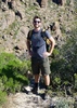
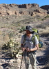
| no partners | | This one has been on my to-do list for awhile. And with the spring season in full swing, I decided to make a quick daddy-daughter trip of it with my high school senior. After school on Friday, we headed up to Tusayan from Phoenix. Stopped in Flag for some pizza and then finished off the drive to Tusayan where we had a motel room reserved. Ordered some breakfast burritos from one of the local restaurant and put them in the fridge for a cold, but hearty early morning breakfast.
Hit the hay at 9:30 and set the alarm for 4 a.m. Packed back up and were out the door by 4:30. Arrived at the Bright Angel TH about 10 to 5 and snagged a parking spot right next to the TH exit. Then we headed down to the Hermit Shuttle stop at 4:55. They start the shuttles at 4:30 am after March 1, and have them on the half hour at 4:30 and 5:00, then at 15 min. increments thereafter.
No one else was at the stop, and the shuttle pulled up literally a minute after we arrived. We hopped on and told the driver we were headed to the end and for a hike down Hermit Trail (I'm not sure why any of the normal tourist, heading to the various lookout points on the rim trail would be interested in taking the shuttle an hour and a half before dawn  ). The driver told us she would still have to stop at every shuttle stop, and told us to make sure we kept our masks on at the back of the bus. ). The driver told us she would still have to stop at every shuttle stop, and told us to make sure we kept our masks on at the back of the bus. 
The bus ride was dark and uneventful. We arrived at the deserted Hermit's Rest and headed out on the trail at 5:35-ish, descending alone into the darkness.
Solitude was our only company all the way until below the Cathedral stairs. The sunrise on the opposing walls was cool and it was turning out to be a perfect weather day. "Breezy" was in the forecast for the afternoon, but that turned out to be a mostly welcome breeze.
I had not been on the Hermit below the Dripping Springs turn off, and the entire section of Tonto was new to me. Loved every step of it.
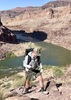
We arrived at the Monument having seen only 3 other small groups. The "Monument" is truly an impressive piece of geology. I'm surprised I haven't seen a triplog of @friendofThundergod having summited it? (Or maybe he has, and I missed it.) In any event, at that point, we made the decision to make a side trip to Granite Rapids. I knew that they were adjusting the river flow from Glen Canyon to simulate spring run off, so we couldn't resist checking it out. Plus, we had heard that Granite was an impressive rapid, and there was also some hubris-induced desire to make this a full, Rim-to-River-to-Rim trip as well.
The side trip turned out to be a highlight--one that we hoped we wouldn't regret later.... The rapid is impressive and we arrived just as a small rafting group (four, 2-person rafts) were scouting the rapid and planning their run. We decided to filter some water and eat an early lunch while we waited for them. It wasn't long before they came barreling through. It was thrilling to watch them. One of the rafts nearly dumped a crew member, but in the end, they all sailed through fine. 
After the rapid, we began calculating our time on trail and decided we need to start picking up the pace in order to get out at a reasonable time. The climb back up from the river to the Tonto was a little more taxing on my daughter than we anticipated, and I was a little worried about how she might feel another 14 miles later, as we would be staring up at the 3,000 climb from Indian Garden. 
Add to that, we got a little turned around in the Monument Creek Campground and ended up getting off trail a bit before finding the exit up the other side of the side canyon. My daughter was a little frustrated at that point, but thankfully, once we got on top of the far side of Monument Creek and back on the relatively flat, smooth Tonto, she rejuvinated nicely, and we clicked off some pretty good mile times.
As for the Tonto itself, I admit that my expectations were a little low in terms of scenery (at least by GC expectations), but I was very pleasantly surprised by the fantastic views--with the the Salt Creek-to-Horn-Creek plateau traverse taking the cake--amazing views of the river, and spectacular cathedral walls on the south canyon side.
Also, from Monument to just before the junction with Plateau Point, we enjoyed perfect solitude.
I went through three full liters from Granite Rapids to Indian Garden, and reinforced that the waterless stretches of this hike would be a death wish in the summer months. Indeed, as we passed through Horn Creek, I thought of the account in Deaths in the Canyon about the young military couple who ended up dying there from a freak flash flood during summer months when the temps topped 115 for several consecutive days. Sad stuff.
We arrived at IG earlier than we thought we would. There were a handful of other R2R and other hikers milling about, but soon they left and we had the place to ourselves. I changed into fresh socks and was once again amazed at how refreshing that can be on a long hike.
Both my daughter and I have hiked IG to the rim several times, so we knew what we were in for, and although she had refreshed a bit, I was still worried about a breakdown--as I have seen a lot of carnage from IG to the Rim among people who were "feeling pretty good" on the lower section of that final push.
But my fears turned out to be totally unjustified. She did awesome. And while we had prepped mentally for finishing in the dark, we beat the darkness and kept a respectable 32-35 minute mile clip on the entire climb. It helped that the weather was perfect--with cloud cover and mild temps all the way to the top. And as it was closing in on the end of the day, even the normally busy BA trail was light on traffic. Trail conditions were nice--mildly slushy and a touch muddy over the last mile, but no problem at all.
We topped out and did a quick change of clothes in the bathroom before heading out to the drive through in Tusayan at Wendy's and then the drive home, arriving around midnight.
Another great trip in the canyon, and excellent memories with my daughter! Can't wait to do this one again! |
| _____________________
| | |
|
|
|
 Route Editor


 Probably the best part of the whole trip was when Margeaux and the crew threw Madi a birthday party at the river, complete with cake and singing! She loved the attention (and the cake)! What a special moment for her.


 Cool weather most of the day and not much sun. Was dark by the time I got to 3 mile resthouse. Very little snow on BA and just a few icy spots. No buses running on Hermit Road so I walked back to my car, taking a couple of short cuts through the woods, following the power lines. Then I remembered mountain lions are known to roam around the these areas close to the village. Comforting thought.