username
X
password
register
for free!
help
ArticlesGuidesRoutes
 
Photosets
 
 Comments
triplogs   photosets   labels comments more
Picketpost - Eastern Approach - 3 members in 9 triplogs have rated this an average 3.3 ( 1 to 5 best )
9 triplogs
login for filter options
Dec 01 2022
avatar

 Guides 6
 Photos 346
 Triplogs 225

69 male
 Joined May 13 2002
 Tempe, AZ
Picketpost - Eastern ApproachGlobe, AZ
Globe, AZ
Hiking avatar Dec 01 2022
hikeazTriplogs 225
Hiking12.50 Miles 2,350 AEG
Hiking12.50 Miles
2,350 ft AEG
 no routes
Linked   none no linked trail guides
Partners none no partners
Hiked from the Picketpost TH through Arnett Canyon and took the cherry-stem road up to the Apache tear mine and mined a few tears. Then off-trail down to the Telegraph junction, hiking westward and to the eastern Pickepost approach ramp. Having not been up Pickepost recently I was surprised to see the bench missing, although the mailbox IS intact..
We exited down the traditional route back to the TH. Saw merely 4 folks in Arnett and no one on Picketpost or its trails.... weekday hiking bonus!
foliage observationfoliage observationfoliage observationfoliage observationfoliage observation
Autumn Foliage Observation Substantial
wildflower observationwildflower observationwildflower observationwildflower observationwildflower observation
Wildflowers Observation Isolated

water 1 out of 5water 2 out of 5water less than maxwater less than max Arnett Canyon Light flow Light flow

water 1 out of 5water 2 out of 5water less than maxwater less than max Telegraph Canyon Light flow Light flow
_____________________
"The censorship method ... is that of handing the job over to some frail and erring mortal man, and making him omnipotent on the assumption that his official status will make him infallible and omniscient."
George Bernard Shaw
 
Feb 28 2016
avatar

 Guides 31
 Routes 135
 Photos 2,699
 Triplogs 615

52 female
 Joined Apr 02 2007
 Scottsdale, AZ
Picketpost Mountain SummitGlobe, AZ
Globe, AZ
Hiking avatar Feb 28 2016
Crzy4AZTriplogs 615
Hiking4.40 Miles 1,921 AEG
Hiking4.40 Miles   3 Hrs   30 Mns   1.47 mph
1,921 ft AEG      30 Mns Break
 no routesno photosets
1st trip
Linked   linked  
Partners partners
GI Jones
In-laws in town to watch kids while we got away for a night. Stayed in Mesa. Had dinner and drinks for the first time at AZ Wilderness and loved it! Next morning drove to hike Picketpost. I should have read more and researched more. The hike was a cluster-F. Not even sure how I got up/down without some sort of injury. Tons of scrambling and slipping. I stuck with another group going up and merged with two other groups coming down. None of us knew what the F we were doing. Or maybe there aren't trails - or I don't know - but I'll never do this hike again unless I'm with someone who knows how to get up efficiently and without risking injury. At the top - sat for a while ALONE - because Brad bailed long before the top. He kept slipping and just not worth getting hurt. I am mad at myself for not getting GPS route on phone or reading more or prepping more. Somehow I thought this was a well-traveled hike and couldn't be a way to "mess it up". So wrong.
wildflower observationwildflower observationwildflower observationwildflower observationwildflower observation
Wildflowers Observation Moderate
brittlebush insanely pretty
_____________________
 
Feb 22 2016
avatar

 Guides 6
 Photos 346
 Triplogs 225

69 male
 Joined May 13 2002
 Tempe, AZ
Picketpost - Eastern ApproachGlobe, AZ
Globe, AZ
Hiking avatar Feb 22 2016
hikeazTriplogs 225
Hiking2.50 Miles 1,646 AEG
Hiking2.50 Miles   3 Hrs      0.83 mph
1,646 ft AEG
 no routes
Linked   none no linked trail guides
Partners none no partners
Great day for this hike- warm but with a nice breeze. I had not hiked this summit from the east before so I thought I'd have to see what it had to offer.
Following the posted driving instructions (thanks!) brought me to where appeared to be a good starting point. Looking up at the top of the ridge (not the actual summit, which is hidden from view) it appears pretty daunting at first but the route is thankfully very obvious. So up I went, easy walking up the first ramp, then skip around to the second - still easy. As you get higher though, the steepness kicks in and will remain your constant companion for the remainder of your assault. Be sure to locate the larger firm rocks to step on and it's a walk-in-the-park, although an aerobic one.
With a couple of short rest stops/reconnoitering it took me about 90 minutes to the summit, which is about 10/15 minutes from where you will top out on the ridge. New to me was a metal bench located adjacent to the mailbox.
As it was Monday there was no one up on the summit - quite the change from the average spring weekend day. I spent about 30 minutes cruising around to peruse down all of the different vantage points to get the full picture of all the varied terrain.
I was not looking forward to the trip down as there are many loose rocks and ones that become loose when you step on them - but in actuality in was not bad at all with prudent foot placement and I was back at the truck in 60 minutes from the summit with only one ride-a-rock to my credit.
The road in is fun if you are equipped with good tires/vehicle, but leave the Prius at home. Just for shucks I left my truck in 2WD (rear is ltd. slip) and it made it in/out just fine. I'd say one would need 7"/8" of clearance to be safe, and heavier tires, as the pointed rocks are prevalent.
Saw one mulie and gobs of lizards, but that was about it.
wildflower observationwildflower observationwildflower observationwildflower observationwildflower observation
Wildflowers Observation Isolated
Globe Mallow and one lone poppy!
_____________________
"The censorship method ... is that of handing the job over to some frail and erring mortal man, and making him omnipotent on the assumption that his official status will make him infallible and omniscient."
George Bernard Shaw
 
Jan 07 2012
avatar

 Triplogs 100

40 male
 Joined Jan 03 2011
 chandler, Az
Picketpost - Eastern ApproachGlobe, AZ
Globe, AZ
Hiking avatar Jan 07 2012
DBmoonerTriplogs 100
Hiking4.30 Miles 1,646 AEG
Hiking4.30 Miles
1,646 ft AEG
 no routesno photosets
1st trip
Linked   none no linked trail guides
Partners none no partners
dont know if the distance is right or not we had 2 gps and they all gave us 2 different distances but they were both really close. This hike can be really steep and the ground is loose so watch your step. we went up one way and then came down a different way.the best way that we saw up was going up to a saddel and then you go to your left and work your way to the bottom of the cliffs were it was the flatest part of the trail , you walk a short distance along the cliffs and you look for a spot were there are sevral boulders you can climb up . when you get to the top you wil see the cross just to your left. you can go down this way but it can be a hard climb down . the way we went down was befor you get to the hill were the cross is if you look to the right you will see the ground sloping down and it is very steep you work your way down and to the left and walk along the side of the cliff again . watch your footing here a fall here could be bad. you will hit a littel hump you climb over and then there is a ravine on the other side . we took a right at the ravine and followed it almost all the way down the boulder hoping was a nice change .
_____________________
  1 archive
Jan 07 2012
avatar

 Guides 6
 Photos 346
 Triplogs 225

69 male
 Joined May 13 2002
 Tempe, AZ
Picketpost Mountain SummitGlobe, AZ
Globe, AZ
Hiking avatar Jan 07 2012
hikeazTriplogs 225
Hiking4.00 Miles 1,921 AEG
Hiking4.00 Miles   3 Hrs      1.33 mph
1,921 ft AEG
 no routes
Linked   linked  
Partners none no partners
Fantastic weather for this hike and not windy at the top, which is rare.
While up there we met a bunch of easterners who climbed up from the east northeast side and have been doing so every year for something like 18 years. They brought wine & cheese, which they said is also part of the tradition.
We, on the other hand, waited for craft beers in the parking lot, along with a 2 hour horseshoe tourney and then late lunch @ Los Hermanos.
_____________________
"The censorship method ... is that of handing the job over to some frail and erring mortal man, and making him omnipotent on the assumption that his official status will make him infallible and omniscient."
George Bernard Shaw
 
Jan 01 2012
avatar

 Routes 596
 Photos 9,604
 Triplogs 2,400

58 male
 Joined Jan 30 2011
 Chandler, AZ
Picketpost Mountain SummitGlobe, AZ
Globe, AZ
Hiking avatar Jan 01 2012
JuanJaimeiiiTriplogs 2,400
Hiking5.00 Miles 2,176 AEG
Hiking5.00 Miles
2,176 ft AEG
 
Linked   linked  
Partners partners
BobP
DBmooner
IHike
outdoor_lover
SunHiker
New Years Day Toast and Kick Off "Hike Arizona" Style! Pam put together a HAZ hike at Picket Post. I had plans to go to Globe but this sounded good. Bob and I spoke about it early this morning as he wanted to do an up and over and then back up and over.

I am planning on doing the Eastern approach (up) another day with the Cannondale Kid but I had time to do an up and over. We parked my car on the Superior side down Telegraph Canyon road. This put us behind a little in meeting the group but not too much. I hustled up the trail and in classic Bob style he took a path less traveled. About half way up I see Pam with what looks to be everything she owns strapped to her back. After a brief introduction she tells me what is in her bag of tricks. Mmmmm, I think to myself. Shortly thereafter I meet Devon, then Gabby and Jennifer. Bob is somewhere in the bushes. Then we regroup up top and meet another gent and eventually a couple other girls. Popular place to be on New Years I would say!

After a bit it was time to head out and Bob and I went down the Eastern side. I continued on and walked the road back to where my car was parked. Bob turned and went back up an alternate route. This was a great hike and it was a treat to meet some more Hike Arizona folks! My next trip UP will hopefully be with Mark (Cannondale Kid) from the Eastern side!
_____________________
 
Dec 24 2011
avatar

 Routes 596
 Photos 9,604
 Triplogs 2,400

58 male
 Joined Jan 30 2011
 Chandler, AZ
Picketpost Mountain SummitGlobe, AZ
Globe, AZ
Hiking avatar Dec 24 2011
JuanJaimeiiiTriplogs 2,400
Hiking4.49 Miles 2,176 AEG
Hiking4.49 Miles   2 Hrs   30 Mns   1.80 mph
2,176 ft AEG
 
Linked   linked  
Partners partners
CannondaleKid
I had been following the Cannondale Kids post about doing an Eastern Approach on Picketpost. The thought of it was intriguing, not to mention I REALLY like Picketpost in general. It's just a cool hike that is not the norm. Plus I needed to mail a couple letters.

Anyway I told Mark (Cannondale Kid) that if I finished my Reavis Ranch hike in time I would come meet him. The plan was to go up the normal route and do some recon from above. That combined with his two prior attempts would hopefully reveal a way to accomplish the mission.

Once up top we signed in at the good old red mailbox and then headed over to the North-East. There is a white horseshoe cross up there and just South of that is a large cairn. We looked over the edge from a bunch of spots. We were really close to where Mark had almost made it up on his last attempt before cliffing out.

Here's the thing! Just below the cairn is a weakness where there is a bit of a rock slide and a way down. It isn't the best and there may be better routes but it looked doable. I tried to convince Mark to have a go at it and then hike down Telegraph Canyon road to Superior. I had envisioned hitchhiking from there back to the trailhead. Mark wanted to save it for another day since he had prior plans and this would take a long time.

Then Mark offered to hike down the normal route and come around and get me on the dirt road if I wanted to give it a shot. I figured what the heck. On the way down I started to second guess my decision. Although the rocks are large they aren't very secure. I took it easy and slow and Mark waited above for a bit to be sure I was going to be able to make it. After about 10 minutes or so we were good and he went on his way.

I would say there are a few ways to accomplish this if you are into such a thing. It should be noted that the road (Telegraph Canyon) requires a 4x4 after the first couple miles. A passenger car could go as far as the little camp area. From here you would need to hike the road up a ways. The ox-bow in the road is a good place to start from.

If you attempt this be extremely careful. The rocks are loose and there are lots of cliffs with big drop offs.

Hopefully my next trip up and over Picketpost will be from the Eastern Approach.

Mark that was super cool and it looks like we figured out the last little piece for you to conquer your mission. Thanks for letting me be a part of it! Also thanks for coming around and picking me up.

Merry Chrismas Everyone!
_____________________
 
Dec 21 2011
avatar

 Guides 44
 Routes 162
 Photos 24,766
 Triplogs 2,411

75 male
 Joined May 04 2004
 Mesa, AZ
Picketpost - Eastern ApproachGlobe, AZ
Globe, AZ
Hiking avatar Dec 21 2011
CannondaleKidTriplogs 2,411
Hiking1.76 Miles 1,404 AEG
Hiking1.76 Miles   2 Hrs   59 Mns   1.24 mph
1,404 ft AEG   1 Hour   34 Mns Break15 LBS Pack
 
Linked   none no linked trail guides
Partners none no partners
Two days after my aborted first attempt and the weather looks way more promising so I'm pretty confident this attempt will be successful. After all, I did more research, poring over maps, sat images, photos and previous GPS routes and cameup with three routes that may lead to success. :D

I stopped on Telegraph Canyon Road just past the second cattle guard, set up my tripod and took a number of full zoom photos to help with my route selection. After scanning the complete eastern face of Picketpost I realized one option is simply not feasible and the next did not appear much better so I fell back what I considered the best approach, which was the return route of my first attempt.
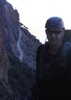
Prepping at the TH:
I'm laying everything out on the hood of the car to make sure I'm not missing anything before suiting up. Actually it didn't take as long as usual because I decided to go a bit leaner with 10 lbs less in my CamelBak than last attempt. Almost ready to go.

All of a sudden I heard what came to mind as a galloping horse but not knowing what it was or where it was coming from I didn't waste any time grabbing my camera, taking it out of its bag, flipping it to Movie and turning it on. But in that few seconds a huge coyote comes tearing out of the brush not 20' from me at full bore with a look that seemed it was desperately trying to get away from something.

Ok, so I figured if something is chasing it, I'd like to get a shot of whatever that would be and waited... and waited... nothing! Such high drama was over in seconds with nothing left to show for it. :(

Oh well, I'm here for the ascent, so let's get started:

1. No 100 yard warmup this time... barely a hundred feet and I'm climbing a steep embankment through ocotillo, prickly pear cactus, and cholla. But though the calorie burn starts sooner, once past the first 200' elevation gain the general route continues at a more reasonable and steady incline. This route was great! I got to the ravine choke point in 32 minutes, less than half the time of two days ago.

2. Immediately after the choke point comes the first real aerobic test... it took 24 minutes to gain 400' of elevation in less than 1000' of forward progress. Whew! :wlift:

3. After that I needed to stop at the small saddle and take in another 250 calories to fuel the next even steeper section.

4. Man! This is the killer... I thought the previous section of 4' up for every 10' forward was rough... This last section took me up 545' in only 827' forward progress... that's climbing up 6' 7" every 10' forward! :wlift: :wlift:

5. By the time I reached a sheer wall of 15-20' tall rocks ](*,) my arms and legs were both getting shaky from the effort, so although I was within 80 feet horizontally from my goal, the vertical 40 feet left to climb presented a bigger obstacle than everything up to that point. :scared:

6. So close, yet this section would require assistance of some kind... But I simpy did not have the energy to jump up 3-4 feet to grab onto what may not even be a stable hand-hold, let alone pull myself up with no footholds. It was decision time but in reality, being completely alone, the only rational decision was to give it up and head back down while I had enough energy to do that with some measure of safety.

7. Although let down by another attempt coming up short, the weather was great so I spent more time taking in the awesome scenery by sight as well as with the camera. The snow on Madera & Pinal Peaks was something I could not see two days before. The trip down passed more easily than I expected, of course I'd been up, down and up most of the route before.

8. Almost to the TH and my head is killing me... that's when I realized I had my Hero HD video camera still pressing against my forehead. What a relief it felt to take it off. Now that I think about it probably I should have taken a photo of myself with the square divot in my forehead to prove it. But then I ended up with over two hours of video.

I know, I know... nobody would sit through two hours of huffing and puffing so I only uploaded the last 15 minutes of the climb before turning back. For those who enjoy seeing/hearing someone feel the pain expending prodigious amounts of energy, have at it:
http://www.changephoenix.com/11/V2011-1 ... ostP3.html

Ok, now I need to hike Picketpost the usual way and take a look down from above to see if there is a better way to do the last 80'. If so, I might look at doing a shuttle hike up one side and down the other to finally call this task accomplished.
_____________________
CannondaleKid
  1 archive
Dec 19 2011
avatar

 Guides 44
 Routes 162
 Photos 24,766
 Triplogs 2,411

75 male
 Joined May 04 2004
 Mesa, AZ
Picketpost - Eastern ApproachGlobe, AZ
Globe, AZ
Hiking avatar Dec 19 2011
CannondaleKidTriplogs 2,411
Hiking1.90 Miles 1,306 AEG
Hiking1.90 Miles   2 Hrs   57 Mns   1.41 mph
1,306 ft AEG   1 Hour   36 Mns Break28 LBS Pack
 
Linked   none no linked trail guides
Partners none no partners
Ok, here it is... Picketpost East by the numbers:
1. Drive through mud, over cattle guard, up rocky hill, down steep rough and rocky hill, up another, over a high stepped cattle guard, down a bunch of boulder steps, up, down, up, down and you're at the TH. Or something like that...

2. I can't even see the base of the mountain and thus have no idea what route to start on, so I kept on driving for a few hours checking out every side road over a 3 mile radius.

3. Ok, a little clearing of the fog and I'm ready to start hiking. A hundred yards of warm-up then it's time to burn the calories... I'm following game trails as much as possible but no being the size of game I have to abandon each one much too soon.

4. Climb through a cholla forest at the same time as carefully placing each step so as not to slide back every other step on the loose gravel. Climb up boulders using every piece of brush available to gain purchase.

6. Traverse along a narrow ledge until it's time to do the real steep climbing. Not so much straight up since there are plenty of ledges, but the quick altitude gain is the killer.

7. Heavy fog has descended again and all I can do is keep checking my GPS to keep me going the overall direction as I have to continously pick out the best route for the next 20-50'. I see a ridge, hoping it brings me to the plateau... I get there and there's another... one more time and I know I'm within 300' of elevation from the white horeshoe cross I know is up there and it's hopeless, I have no idea where to find the path through the boulders.

8. Head back down before the heavy gray clouds roll in. In more of a hurry now I choose a different route that would probably cut a good 15-20 minutes off the climb. Yup, it's always easier to pick the fast route on the way down.

9. The final part of the route takes me through cholla (a different forest on the return trip), prickly pear, ocotillo and palo verde before I get back to the car.

10. I'm totally soaked through 4 upper layers, I have dirt all over me from the body slides and weirdly enough, my socks are the cleanest item although thoroughly wet as well since I was wearing my Teva's.

That's it for the hike... although aborted I feel it was successful because I know it can be done... and I'll be doing it soon, like in a day or two.

The drive after the hike again took me past Ajax Mine where I took some photos of the mine itself (instead of the mill as before) and the few tailings.

Video of a rough part of my climb is coming soon.
_____________________
CannondaleKid
 
average hiking speed 1.35 mph

WARNING! Hiking and outdoor related sports can be dangerous. Be responsible and prepare for the trip. Study the area you are entering and plan accordingly. Dress for the current and unexpected weather changes. Take plenty of water. Never go alone. Make an itinerary with your plan(s), route(s), destination(s) and expected return time. Give your itinerary to trusted family and/or friends.

helpcommentissue

end of page marker