|
| | | |
| |
|
| Hiking | 18.00 Miles |
6,462 AEG |
| | Hiking | 18.00 Miles | 16 Hrs | | 1.38 mph |
| 6,462 ft AEG | 3 Hrs Break | 16 LBS Pack | | |
|
|
| |
| Partners |
|
[ show ]
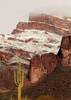
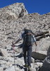
| partners | | Three of us did this incredible hike - Brian W, Jim H, and myself. Brian and I started around 5:40 AM and Jim started a bit later than us but caught up about an hour before iceberg lake. We ALL made it to the top of Whitney but we almost didn't make it. Wow, it was amazing, a bit crazy & at times dangerous. We took the mountaineer's route which I do not recommend because after getting to iceberg lake (elevation ~ 12,600 feet) there's a hike up to a notch which involved loose gravel and a VERY steep climb which was about 1 mile long and elevation gain of something like 1,500 feet in that single mile. About 2/3 of the way up, there was a hail storm. I put on my rain jacket and because of the steep angle it was impossible not to step on it as I was doing this very steep climb and within a few minutes my rain jacket was torn apart and flapping in the wind. At the top of the notch we got cover and waited for the hailstorm to stop. Then, there was a technical 400 foot climb to the summit, which took us about 45 minutes. The hail stopped and started again a few times during the final ascent. None of us experienced any headaches or elevation sickness despite the storm and difficult conditions at the top. I had a knit hat which helped keep me from shivering. Brian and Jim were shivering at the top which dropped as low as 40 F that day, around 5:30 pm. Because of the hail, we went into the stone shelter and waited there for at least 1 - 1.5 hours. We realized that the hail would not end therefore we decided that we were going to leave there at 5:30 pm regardless of weather conditions.
Around 5:30 pm, we left the stone house and it was still hailing pretty hard. Hail was "pea sized" and sometimes larger. Before leaving, we signed the log, paused for 2 minutes to get a few quick photos up there and took off. There was an inch of "ice pellets" on the ground which looked just like snow. From this point we had 11 miles of good trail to get to the bottom. The top 3 miles was covered in snow but it was relatively easy to follow the trail down. After 3 miles we got out of the snow zone and the path was clear of any snow. We eventually got to the famous 99 switchbacks and went down. We counted all switchbacks and there really was 99. Then we were at Consultation lake and from this point we had 6.5 miles left to get to the bottom. We kept going, taking only short breaks, once or twice to filter spring water when we were low. We finally got to the Whitney Portal trailhead at 1:19 AM !! It was such a long and tiring day but we all made it safe. My phone battery was dead 3 minutes after I reached the peak but I was able to get some nice pics and videos all the way up. One of our friends, Brian, still had a working camera. I regret not taking my camera and relying on just the smart phone. A smart phone is quite dumb when it's out of battery!! Anyway, Brian was able to get photos of all of us at the peak and several other photos and videos after summiting. It was an adventure I'll never forget!! If we do it again, we would probably just use the MAIN trail, even though it would be 22 miles. Our route up and down was probably around 18 miles. I exported our GPS track from Strava and Hike Arizona.com measured our AEG at 6,462 and route up at 6.99 miles.
Timeline:
----------
05:30a parked the car (8,333 feet elevation)
05:35a started hiking (8,333 feet elevation)
05:59a reached 1 mile in distance (8,708 feet elevation, previous mile in 24 minutes)
06:00a switched to the Mountaineer's route (8,723 feet elevation and 1.03 miles)
06:45a reached 2 miles (9,682 feet elevation, previous mile in 46 minutes)
07:32a reached Lower Boy scout lake (10,344 feet elevation). This was at 2.6 miles.
08:06a reached 3 miles (10,554 feet elevation, previous mile in 1 hr 21 minutes)
08:45a got a little off track but was able to see Thor falls up close (11,121 feet elevation, 3.44 miles)
09:16a reached the main section of the trail and met up with Jim (11,211 feet elevation, 3.82 miles)
09:29a reached Upper Boy Scout lake (11,313 feet elevation, 3.94 miles)
09:33a reached 4 miles (11,381 feet elevation, previous mile in 1 hr 27 minutes)
10:33a reached 5 miles (12,407 feet elevation, previous mile in 1 hr)
11:19a reached Iceberg Lake (12,650 feet elevation, 5.41 miles). took a long break.
11:48a left Iceberg Lake, heading up to notch (12,797 feet elevation, 5.51 miles)
12:43p reached 6 miles (13,474 feet elevation, previous 1/2 mile in 55 minutes!)
01:10p ** HAIL STORM STARTED at this point **
02:08p reached notch (14,135 feet elevation, 6.49 miles). Took 2 hr 20 minutes to get to notch during hailstorm!! Took a break, tried to get shelter during hailstorm.
02:38p started final 400' rock climb (14,158 feet elevation, 6.57 miles)
03:15p reached summit of Mt Whitney! (14,505 feet elevation, 6.99 miles). Hail was still falling during this time. We got shelter in the stone house and waited.
05:30p left summit even though hail was still coming down. Needed to get to safety regardless of weather.
(phone was dead so could not track GPS/progress)
01:19a finally made it to Whitney Portal! |
| _____________________
Michael Williams
IT Professional
Rocky Point Vacation Rentals
Ocean Front Condo in Rocky Point, Sonora, Mexico
www.beachfrontmexico.us
 |
| | |
|
|
|
 Route Editor