username
X
password
register
for free!
help
ArticlesGuidesRoutes
 
Photosets
 
 Comments
triplogs   photosets   labels comments more
7 Up To Hyde Mountain Trail #5 - 5 members in 13 triplogs have rated this an average 2.8 ( 1 to 5 best )
13 triplogs
login for filter options
Aug 06 2023
avatar

 Routes 1
 Triplogs 3

male
 Joined Jan 15 2023
 Prescott, Arizon
Hyde Mountain #6 #5 Loop, AZ 
Hyde Mountain #6 #5 Loop, AZ
 
Hiking avatar Aug 06 2023
carsonkTriplogs 3
Hiking6.50 Miles 1,418 AEG
Hiking6.50 Miles
1,418 ft AEG
 no routesno photosets
1st trip
Partners none no partners
Hiked from the trailhead on FR 95C up to the lookout, then back down from the lookout on #5 to Brown Spring, then took #5 back to its intersection with #6.

The roads from Williamson Valley all the way to the trailhead were in good shape--FR 68 usually is, but I was pleasantly surprised by the condition of FR 95C. Thinning operations had just taken place, so I think they smoothed out the road for that. Some ruts had started to form, but it was nothing that even my little SUV couldn't handle. The signage to the trailhead was pretty good, and there were new metal signs at both the start of #6 and on the other side of the hike at the beginning of #5 that clearly marked each start.

Hyde Mountain Trail #6 was easy to follow all the way to the top, with intermittent shade. It certainly is steep, and the first section has quite a few loose rocks that make it a bit slippery if you're not careful. As you pass the upper intersection with #5, less than a quarter mile from the old lookout, the brush thickens slightly, but doesn't impede progress any more than the steep trail does. The view from the top was absolutely worth it, though: you get a 360-degree view of everything for miles around, and on a day like today that wasn't real hazy, it was stunning. A lot of the infrastructure is still up by the cabin: the building itself is missing a few windowpanes but you can see the old map table along with a portable radio tower, some shed-like structures, and an outhouse.

I veered right on my way down at the upper intersection of #5 to check out Brown Spring; green grass grew around it, and it trickled down to an old water trough. A couple of deer were hanging out in the area too. I took #5 back to its lower intersection with #6 to turn it into sort of a quasi-loop. This part of the trail was also intermittently shaded, particularly at the bottom, where taller pines grew. This was certainly a welcome relief from the scrubby junipers at the top of Hyde Mountain, although the breeze was unsurprisingly much nicer at the top of the mountain.

Bring lots of water on this one, especially if doing it this time of the year, but it's worth it at the top for the unparalleled view of the surrounding landscape! Definitely choose a clear day for this one.

water 1 out of 5water less than maxwater less than maxwater less than max Brown Spring Dripping Dripping
Trickling down to water trough. Could dig it out to filter at the source, which would give you enough for one or two people.
 
Mar 23 2022
avatar

 Routes 154
 Photos 1,505
 Triplogs 266

31 male
 Joined Jun 02 2019
 Phoenix, AZ
Hyde Mountain Loop, AZ 
Hyde Mountain Loop, AZ
 
Hiking avatar Mar 23 2022
LJWTriplogs 266
Hiking26.51 Miles 3,707 AEG
Hiking26.51 Miles   10 Hrs   20 Mns   2.84 mph
3,707 ft AEG   1 Hour    Break
 
Route Scout Route Recorded  on Route Scout | Pop | Map | Popup | MapDEX
Thinning operations are taking place SW of the Hyde Mountain area around Camp Wood and Yolo Ranch. Thinning will be taking place for approximately two months, with logging traffic on the road. The closure area will spread north as thinning continues into the slated 627 acres. From now until monsoon season, I would consult PNF on closure status for accessing Apache Creek Wilderness.

Wanted to remix a hike from last year to include Apache Creek from the springs down, as well as try out an alternative ending using an old ranching track and Dead Steer Basin Trail. Got going with Stringtown Wash heading toward Hyde Mountain.

Memories of Stringtown only a year old undersold. Tight walls and a bed of slick rock in the middle turns into relaxing open pine forest on the upper end. Good flow of water where it mattered, some of the way it was underground. Catching the trail on the upper end from the creek bed is tricky.

Hyde Mountain trail rocky and loose to hazy views. Almost no snow left on the shady slopes. Down 7up to Browns Spring and then up to the saddle and onto Pinetop Mountain. Followed the fenceline up and found a gate on top near the end of the road. Delighted by the big junipers and pines on top. Easy road walk to Apache Springs.

Apache Creek along the trail is easy going, defined by the grassy meadows, open pine forest, and lazy creek flow. From the springs to that point it's a gnarly canyon of granite boulders and outcroppings, forested but with healthy undergrowth. Can follow the water down except for in several spots where the water pours off and work-arounds are necessary. Some scrambling, light bushwhacking. The best of the creek is above the trail.

The Upper Graver Wash/Apache Creek jct is grassy and could be confusing heading up. Graver and the way down Apache Creek Trail is obvious. Decided not to cut it short and went all the way down to Graver, then walked the road back to Upper Graver TH. To the east there is a corral and an obvious trail. The trail leads down into Hyde Creek and dead ends at another corral. At that point I went over the ridge and into Dead Steer Basin, where I found the trail.

Dead Steer Basin Trail is an old double/OHV track. It is less pretty than the trail to Hyde Creek; it got burned over pretty bad. It's easy to follow and in good shape until the last creek crossing near where I picked it up. Once to the TH and FR95, the diversion started to make sense. The rest of the roadwalking back to Stringtown is through some awesome forest. The new sections and route finding made for a more engaging but difficult way to end.
wildflower observationwildflower observationwildflower observationwildflower observationwildflower observation
Wildflowers Observation Isolated


water 1 out of 5water 2 out of 5water less than maxwater less than max Apache Springs Quart per minute Quart per minute
Total guess, good enough creek flow

water 1 out of 5water 2 out of 5water 3 out of 5water less than max Pinetop Trick Tank 51-75% full 51-75% full

water 1 out of 5water less than maxwater less than maxwater less than max Stringtown Wash Pools to trickle Pools to trickle
  3 archives
Nov 10 2021
avatar

 Guides 264
 Routes 2,797
 Photos 14,494
 Triplogs 5,894

55 male
 Joined Nov 20 1996
 
Hyde Grapevine Lasso Loop, AZ 
Hyde Grapevine Lasso Loop, AZ
 
Hiking avatar Nov 10 2021
joebartelsTriplogs 5,894
Hiking5.39 Miles 1,550 AEG
Hiking5.39 Miles   2 Hrs   32 Mns   2.16 mph
1,550 ft AEG      2 Mns Break
 
1st trip
Route Scout Route Recorded  on Route Scout | Pop | Map | Popup | MapDEX
Hyde #6 is a road that turns into a trail. Pretty good all the way up, except some Y-Bar ankle busters for stretches. Itty bitty dead itchies hitch a ride on your socks at the top and on the way down Trail #5. #5 is a hint of a trail but is as the 2012-11-18 Official Route depicts, at least to Grapevine #9825 where we turned off. Easy enough to negotiate but occasional juniper limbs just need a quick snip.

Grapevine is a road. Easier to follow, nice to look forward and stroll across the forest.

We had a few options for a secondary peak heading back to the valley. After three strikes, we threw in the proverbial towel.

The retired four-year-old still rambles around and amuses/mystifies/intimidates his surroundings... ahem, non-stop. Good times with little Robbert Senior!
_____________________
- joe
 
Nov 10 2021
avatar

 Guides 2
 Routes 251
 Photos 4,593
 Triplogs 3,212

63 male
 Joined Feb 26 2008
 Scottsdale, AZ
Hyde Grapevine Lasso Loop, AZ 
Hyde Grapevine Lasso Loop, AZ
 
Hiking avatar Nov 10 2021
BobPTriplogs 3,212
Hiking5.39 Miles 1,550 AEG
Hiking5.39 Miles   2 Hrs   32 Mns   2.16 mph
1,550 ft AEG      2 Mns Break
 no routes
1st trip
Partners partners
joebartels
T.C. Hyde was born in Ireland in 1868 not that far from the Blarney Stone. He came to the US in 1888. Upon entering Castle Rock, he entered the Army and headed to CO. He fought in Cuba, China, Philippines, and in the US. In the early 1900's, he settled in MA and married. He worked on the USS Constitution and then in a munitions factory. T.C. fathered 9 children in 13 years. T.C. died when his wife was pregnant with child number 9. He died after reading a book. I'm not sure what the title was but I visited the spot where it happened. T.C. spent some time in Leavenworth, KS. He was a giant of man when standing next to his 5'3'' brother. Not sure how tall his other brother was but when you add the rope he hung from he towered over them all.

Hyde Mountain is not named after T.C. but if you visit Ireland and tell them his name the most likely answer will be all Hyde's are related.

The hike was nice and the weather was fab maybe a tad too chilly at the start. Joey was Joey and sometimes he acted like Seph. He whined about not wearing his pack correctly for about an hour. I think it had more to do with him chewing on cardboard and drinking Monster. Then he blamed it on my driving :stop: .
_____________________
https://www.seeitourway.org
Always pronounce Egeszsegedre properly......
If you like this triplog you must be a friend of BrunoP
 
Apr 03 2021
avatar

 Guides 13
 Routes 38
 Photos 1,651
 Triplogs 577

60 male
 Joined Nov 15 2005
 Jackson, CA
Graver Wash Trail #9904 - Prescott NFPrescott, AZ
Prescott, AZ
Hiking avatar Apr 03 2021
toddakTriplogs 577
Hiking24.00 Miles 3,000 AEG
Hiking24.00 Miles   10 Hrs      2.40 mph
3,000 ft AEG
 no routes
1st trip
Long haul out to this area but worth it, thanks to @LJW for the recent report. I would have never thought anywhere in AZ could have this much flowing water right now, still don't know how the small, relatively low Santa Marias apparently stay relatively wet. No doubt I'll be back.

Parked about 3/4 mile from the trailhead, did the loop CCW. Apache Creek and the summit of Hyde Mtn are great, most of the road walking is not unpleasant. Stringtown from the west side follows the creek before climbing SE out of the drainage fairly close to the route shown on the FS map, and there is a decent path cut through the manzanita and pink ribbons help stay on track. Even so I eventually lost it, but easy to continue east to hit FR95.
_____________________
  1 archive
Apr 01 2021
avatar

 Routes 154
 Photos 1,505
 Triplogs 266

31 male
 Joined Jun 02 2019
 Phoenix, AZ
Hyde Mountain Loop, AZ 
Hyde Mountain Loop, AZ
 
Hiking avatar Apr 01 2021
LJWTriplogs 266
Hiking23.21 Miles 3,063 AEG
Hiking23.21 Miles   7 Hrs   49 Mns   3.17 mph
3,063 ft AEG      30 Mns Break
 
Route Scout Route Recorded  on Route Scout | Pop | Map | Popup | MapDEX
Original plan was to do a shuttle from Hyde Mountain through the full length of Apache Creek Trail with a stop at Granite Knob. Ended up solo, so I tried to come up with a loop and decided to forgo Granite Knob on account of the added miles. Came up with this one that starts at Stringtown Wash near the Camp Wood area and circles back using roads from the Graver Wash TH. Went clockwise around 8:15am.

FS maps show a road on the east side of the wash and the trail only going about half way through from the west. Figured it wouldn't be too much to work up the wash and connect them. Cows roam Stringtown, so there's all sorts of trails, almost to the point that the FS could just stick plastic cairns in the ground, update their maps, and call it a day. Ended up unexpectedly one of my favorite parts of the trip. There was water trickling through the wash, a few small cascades and a tiny waterfall. Nice forest of pine that gets nicer farther west. It is a little tricky to find where the trail picks up to the west, but if it comes down to it following the wash the whole way makes it to the road.

Brief road walk to Hyde Mountain Trail. Quickly works its way up to the summit. Rocky and loose in parts. Really nice views of Northern and Western AZ from the top.

Down the west side of the mountain the trail conditions are deteriorated but not too bad and it's easy to follow. Made it down to 95B and walked that to the upper Apache Creek TH. Really nice stretch of road through the pines. Goes along Hyde Creek, which had a light flow of water. Most every creek and drainage was flowing, and there was some snow left on the north side of Hyde Mountain.

Apache Creek Trail starts on the north end in a beautiful clearing in the pines. Not much in the way of parking or signage. There's a small wilderness sign that leads across the creek to the trail. Upper end is steep and the views are big and bouldery. Personal favorite stretch was everything after linking up with Apache Creek. Trail's in good shape, creek had a good flow of water. For a while it's all meadows and pines. The oaks have yet to regrow their leaves.

Graver Wash trail to swing back round. It had the only FS signage and register box by the TH of the trails I saw. It's in good shape and is a nice trail especially for the looping options it affords, but after Apache Creek it won't stop anybody in their tracks. 95A and 95B between the TH and Camp Wood are mighty rough. Road walk was frankly too long but gets good closer to Camp Wood where it enters the forest. Day ended up partly cloudy, low 40s to low 70s. Didn't see anyone on the hike.

water 1 out of 5water 2 out of 5water 3 out of 5water less than max Apache Creek Medium flow Medium flow

water 1 out of 5water 2 out of 5water less than maxwater less than max Brown Spring Quart per minute Quart per minute
A guess, but there was a light flow in the creek

water 1 out of 5water 2 out of 5water less than maxwater less than max Stringtown Wash Light flow Light flow
  4 archives
Sep 13 2014
avatar

 Guides 4
 Routes 491
 Photos 10,890
 Triplogs 1,257

55 male
 Joined Nov 20 2012
 Phoenix, AZ
Stringtown - Pinetop - Apache Creek Loop, AZ 
Stringtown - Pinetop - Apache Creek Loop, AZ
 
Hiking avatar Sep 13 2014
BiFrostTriplogs 1,257
Hiking19.72 Miles 3,498 AEG
Hiking19.72 Miles   10 Hrs   19 Mns   2.34 mph
3,498 ft AEG   1 Hour   54 Mns Break
 
1st trip
Bruce put this loop together in an area that's been on the list. And it happened that Chumley planned HAZfest there as well so after leaving the valley early Saturday morning we rolled into Camp Chumley to find everyone up and about. Took some time to catch up with friends and see if anyone wanted to join on our loop but no takers.

Finally started a bit late after 8am and heading up Stringtown Canyon which was off trail and very cools narrows section about 1 mile from the TH. From there we headed out of Stringtown and linked up with Hyde Mountain Trail. Headed up Hyde Mountain to check out the lookout with great views on top. Spent a few minutes enjoying the views of Juniper Mesa and Humphreys to the north.

The next objective was Pinetop Mountain which required about 1/2 mile bushwhack up steep terrain but turned out to be easier than expected (less Manzanita). Once on top we hiked over to the coolest tank I've ever seen...it has catchment roof system that drains all the water into 6 foot high about 30 foot wide tank. After taking several pics of the area we headed down the road from Pinetop Mountain. The views were better than expected especially looking down into Apache Creek area that we were heading to.

We took roads off Pinetop Mountain but once into Apache Creek it's all off trail. It's not too long before pools of water show up and then some flow to the creek. Soon the best part of the loop develops with nice sections of boulders and narrow slots with small pools. This section continues for about 2 miles but unfortunately for us the thunderstorms rolled in and a downpour ensued. Some of the lightning was very close the last big boom in particular maybe 50 yards away. We smelled burnt pine and sure enough a ponderosa had been struck with pieces of tree lying around. Eventually after more than an hour of hard rain it stopped near the end of the boulder section. There is a nice pool right at the end that we took a swim and a few jumps. Definitely want to do this section again in better weather.

Once out of Apache Creek we hit the trail and then the road for the last 6 miles back to the vehicle. Pretty easy hiking and made it back by 630. Then back to Camp Chumley to socialize and grill some burgers and dogs and share some beverages. Nice to hang out a bit after the hike :)
_____________________
  3 archives
Sep 13 2014
avatar

 Guides 41
 Routes 1,626
 Photos 14,983
 Triplogs 2,760

69 male
 Joined Jan 20 2009
 Far NE Phoenix,
Stringtown - Pinetop - Apache Creek Loop, AZ 
Stringtown - Pinetop - Apache Creek Loop, AZ
 
Hiking avatar Sep 13 2014
The_EagleTriplogs 2,760
Hiking19.93 Miles 3,270 AEG
Hiking19.93 Miles   10 Hrs   18 Mns   2.28 mph
3,270 ft AEG   1 Hour   34 Mns Break17 LBS Pack
 
1st trip
We made the drive out to HAZVille and arrived to a mostly awake camp at 7:45.

After our quick hellos to the gang, a scan to see if we had any takers on our hike, Karl and I headed out with no takers.

I wanted to head up the Stringtown Wash from the east, to see if we could find any sign on the Stringtown Trail #9917. The Prescott Nat. Forest web site description and the PNF GPS track don't come close to agreeing with each other. We did find remnants of the trail starting at about .75 miles from it's Western TH continuing to that spot.

On the Hyde Mountain Trail #6 now, I turn west off the Grapevine Springs Trail #9825 to try something new. The trail name didn't make any sense to me, because the actual spring is to the east and this trail goes to the west off of #6. Checking Sat. views now, it appears there's a faint unofficial trail that goes towards the spring, and what could be a spring box/s .1m off #6, a 1/3rd of the way to the spring location.
Anyway, Karl went up to the top of Hyde to check out the views and we met back up at the lush Brown Spring.

From Brown Spring, we were on a new to me section of the 7up to Hyde Mountain #5 Trail. We went up the saddle and down to the western terminus of this trail by the dry, Camp Wood Tank. We were able to find a blood free route to the top of Pinetop Mountain to check out one of them most elaborate tanks I've seen. This covered tank, uses the roof to funnel the water into the tank. Chumley's math placed it at 22,000 gallons.
FR19 took us off the top of Pinetop Mountain, with it's big views to Juniper Mesa and the Apache Creek Wilderness area we'd be in next.

The 3 mile trek from the Springs to "The Swimmin' Hole", through the water, slots and boulders is the reason we were doing this loop. Wow is this a sweet little off trail jaunt!!
Highly Recommended..... I suppose with a little work you could avoid the water, and like us you'll try for awhile, but don't waste your time. enjoy it!

When we started the day, the skies were blue, with not a single cloud. With only a 30% chance of rain, there was no reason to bring the Chrome Dome, Rain Jacket or waterproof GoPro. Yep we got dumped on and had electric spears thrown at us for almost an hour (back at HAZVille, they did not see a drop).

There was a brief pause where we thought we were in the clear, then a Flash/Boom with zero delay. That was close. 50 yards further up was a Ponderosa that was struck and spewed a 7' section of pine, another 50' away. Based on some of the weather I've hiked in this year, I'm glad I don't have Astraphobia or Ombrophobia... but I should.

With the rain now stopped, we took a dip in "The Swimin' Hole". On the Apache Creek Trail #9905 it was clear sailing back to HAZVille now for some Burgers, Dogs and Barley Pops with the crew.


Video :next: http://youtu.be/NJnKPAy2p_o
 Meteorology
 Meteorology [ checklist ]
[ checklist ]  Forecast  Lightning
wildflower observationwildflower observationwildflower observationwildflower observationwildflower observation
Wildflowers Observation Light

water 1 out of 5water 2 out of 5water 3 out of 5water less than max Apache Creek - Apache Creek Wilderness Medium flow Medium flow
Plenty of filterable water the entire length we hiked.

water 1 out of 5water 2 out of 5water less than maxwater less than max Apache Springs Quart per minute Quart per minute
Spring areas were lush green and water could probably be found. No need though because there was water for the entire length of the Apache Creek

water 1 out of 5water less than maxwater less than maxwater less than max Brown Spring Dripping Dripping
Enough to filter if needed, creek below was flowing with large holes. Careful of cow activity in the area

dry Camp Wood Tank Dry Dry
Dry as a bone even after recent rains

water 1 out of 5water 2 out of 5water less than maxwater less than max Panther Spring Quart per minute Quart per minute
Hard to tell where the spring source was with all the water in the area

water 1 out of 5water 2 out of 5water 3 out of 5water 4 out of 5 Pinetop Trick Tank 76-100% full 76-100% full
7' tall and 30' around filled with filterable water

water 1 out of 5water 2 out of 5water less than maxwater less than max Stringtown Wash Light flow Light flow
Water almost the entire length we hiked next to. Recent rains I'm sure contributed

water 1 out of 5water 2 out of 5water less than maxwater less than max Upper Hyde Spring Quart per minute Quart per minute
Searched for source with no luck. Plenty of water in the wash area, beware of cattle activity.
_____________________
There is a very fine line between "hobby" and "mental illness."
Dave Barry 🦅
 
Aug 16 2014
avatar

 Guides 94
 Routes 840
 Photos 22,055
 Triplogs 1,993

52 male
 Joined Sep 18 2002
 Tempe, AZ
Hyde Mountain - Apache Creek Loop, AZ 
Hyde Mountain - Apache Creek Loop, AZ
 
Hiking avatar Aug 16 2014
chumleyTriplogs 1,993
Hiking25.03 Miles 3,468 AEG
Hiking25.03 Miles   11 Hrs   18 Mns   2.92 mph
3,468 ft AEG   2 Hrs   43 Mns Break
 no routes
1st trip
Partners partners
FOTG
John9L
The_Eagle
Tough_Boots
When I learned that Joe had bequeathed an eagle to me while getting his affairs in order before heading out to go Bass fishing, I decided I better take it out and see if it could fly without him.

I was happy to see that things went well. I had previously known that I can rely on him to do everything and all I have to do is show up. Worked great! I had come up with an alternate plan, but I'm glad we stuck with the original -- with a short detour just to get a little taste of the area I had proposed. Turned out to be a highlight of the day. And by highlight, I mean bright, pasty white, blinding, sunlight reflecting... Luckily the water was perfect and we spent a while diving, swimming, and just having a good time in the middle of our hike.

Apache Creek was flowing for it's entirety, and the monsoon has obviously brought enough moisture here to spring this area to life. It was loaded with green grass and flowers everywhere. It appears to be a healthy ecosystem, with numerous deer sightings, tons of birds, and plenty of scat from coyote, bear, and kitties.

The return portion of our loop was a long road hike that none of us were looking forward to. It ended up being much more tolerable than we thought, but I wouldn't want to attempt to drive it. No stock vehicle could do it. We did pass a group of 6 Jeeps that were making a day of it. I'd have to say that it won't be too many more years before not even Jeeps can make it.

I drank 4.5 liters of water. I think Bruce said it hit 97 in the sun, but I don't think it was ever out of the 80s for real. There was plenty of shade to be found, the breeze kicked up when needed, and late afternoon shadows saved us from getting baked on the road hike. My GPS decided to take a nap for a while, so I'm stealing Bruce's stats.

Great day. I'll be back here for certain.
 Flora
 Flora [ checklist ]
[ checklist ]  Moss
_____________________
I'm not sure what my spirit animal is, but I'm confident it has rabies.
 
Aug 16 2014
avatar

 Guides 41
 Routes 1,626
 Photos 14,983
 Triplogs 2,760

69 male
 Joined Jan 20 2009
 Far NE Phoenix,
Hyde Mountain - Apache Creek Loop, AZ 
Hyde Mountain - Apache Creek Loop, AZ
 
Hiking avatar Aug 16 2014
The_EagleTriplogs 2,760
Hiking25.00 Miles 3,468 AEG
Hiking25.00 Miles   11 Hrs   16 Mns   2.79 mph
3,468 ft AEG   2 Hrs   18 Mns Break16 LBS Pack
 
1st trip
Partners partners
chumley
FOTG
John9L
Tough_Boots
Chum's and I had been tryin' to get in a hike, for what seems like forever. Our schedules never meshed. We'd both scoped out the Juniper Mesa and Apache Creek areas and had ideas on some hikes.

We decided on a loop I'd put together, with an exploration portion for a future adventure.

Somehow Toughboots, 9L and Boy with Dog found out and joined us.

After they wrote letters to their moms, blew their noses and made sure to put on clean underwear, we were off ... slightly late.

We started from the Camp Wood area. Some great camping areas back here! It's a 16 mile drive on a dirt road (FS21, ie Camp Wood Rd) off of Williamson Valley Rd. When dry, this road is doable by just about any vehicle.

After the ladies got all their food, beverages, skirts, snacks, etc.. ready, we were off like a heard of turtles just after 8am. Blanco is a good dog an listens to everything lee says. He did a good job of pointing out the Fauna to us. Numerous deer, Rabbits, Squirrels, Lizards were spotted.

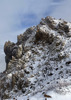
The hike started by gaining 1/2 our daily AEG in the first 4.3 miles to the top of Hyde Peak at 7270'. The Hyde Mountain Trail #6 was slightly overgrown but easy to follow except one short section just below the Lower Saddle. 360 views from up top were just spectacular.
The lookout building from 1936 has a brand new Generator Unit and never used outhouse, but the property does not seem to have been used for a year or more.

Next down the 7 Up to Hyde Mountain Trail #5. This got us into some more tall pines, green grass at the Brown Spring area. At this point Hyde Creek was next to us on the pleasant walk in the pines on no longer used FR52. There was filterable water the entire length.

Off of 52B and on to the Apache Creek Trail #9905. There is no indication for the southern TH. We built a few cairns just off the road for future hikers. The trail is obvious once you get in a 100'. The southern portion area is a bolder wonderland, reminiscent of theWilderness of Rocks trail.

Once we got to Apache Creek we took some lunch and then took the .6 mile hike to what appeared to be a pool of water on the satellite views. We were all surprised to find lot of water on our way up there. For the highlight of the day, we arrived at 30' x 20' and 10' Deep pool of the best swimmin' water around. We took a 1/2 hour cooling off, jumping off the rocks and cooling down.

It's now 2pm and we're only 10 miles into a 25 mile hike, time to move on.

The scenery was not arizona-like at all. More water, pines, deciduous trees, grasses and tall flowers.

We hit the Gravers Wash Trail #9904, and made the turn to the barn.

FR 95A was a slog, but not as bad as first feared. There were views to be had, some shade and even water along the way. It was the ankle busters that get tiresome hiking on. Not everywhere, but enough in the final 8 miles to say... enough.

Short Video from Hyde and the Swimmin' Hole :next: https://www.youtube.com/watch?v=u8Ues1T ... UA&index=3

Chum's shared some of his private stock of Natural Lite with us at the end and it was appreciated!

Good to finally hike with Chum's, 9L, Boy With Dog and again with Bootsie.

Thanks for driving Chum's. We have unfinished business out there
 Flora
 Flora [ checklist ]
[ checklist ]  Moss
 Fauna
 Fauna [ checklist ]
[ checklist ]  Dog
wildflower observationwildflower observationwildflower observationwildflower observationwildflower observation
Wildflowers Observation Moderate

water 1 out of 5water 2 out of 5water 3 out of 5water less than max Apache Creek - Apache Creek Wilderness Medium flow Medium flow
There was water in Apache Creek almost the entire length of our hike.
At the point of this waypoint, the water was 30' x 20' and about 10' deep.

I would think even in the driest times there would be water in this spot

water 1 out of 5water less than maxwater less than maxwater less than max Brown Spring Dripping Dripping
The spring area was dripping, but the creek below was running.

water 1 out of 5water 2 out of 5water 3 out of 5water 4 out of 5 Ruins Tank 76-100% full 76-100% full
As far as tanks go, I'd filter it in a pinch. But there was no need on this day as there were pools of water all along the way.
_____________________
There is a very fine line between "hobby" and "mental illness."
Dave Barry 🦅
 
Aug 16 2014
avatar

 Guides 6
 Routes 183
 Photos 5,612
 Triplogs 1,647

male
 Joined Mar 12 2004
 Scottsdale, AZ
Hyde Mountain - Apache Creek Loop, AZ 
Hyde Mountain - Apache Creek Loop, AZ
 
Hiking avatar Aug 16 2014
John9LTriplogs 1,647
Hiking25.00 Miles 3,468 AEG
Hiking25.00 Miles   11 Hrs   16 Mns   2.79 mph
3,468 ft AEG   2 Hrs   18 Mns Break
 no routesno photosets
1st trip
Partners partners
chumley
FOTG
The_Eagle
Tough_Boots
Big loop in the Apache Creek Wilderness. This was my first time in the area and I was pleasantly surprised. The hike had a bit of everything including a fun swim hole near the halfway point.

We started from a large car camping area that would be worth returning to. We made good time to Hyde Lookout which was very cool! From there we continued north and entered the Apache Creek Wilderness. This was my favorite part. The trail is easy to follow but faint in places. Some route finding was in order and it helped carrying the GPS track. The landscape is rugged and dense. It had a unique beauty in itself. Great area!

Around the halfway point we had lunch and then detoured to the swimming hole. This was the highlight of the trip. The water was cool and refreshing. I need to do this more! Afterward we continued our hike and we headed east at this point. The trail was still faint but it was well cairned. There were large piles of rocks every few hundred yards. It was easy to follow. After a while we turned to the south and continued.

We eventually hit a road and from there had eight miles to go. We basically put our heads down and hiked. A group of jeeps passed us about an hour later. They looked like they were having fun except I didn't see any alcohol. Weird! The last couple of hours blended by as we grinded back to the vehicles. All of us were happy when back to the car to Flat Denny waiting for us.

This was a great area and fun group. It was great to hike with Bruce for the first time. Let's do it again soon! And nice job putting this route together. I really enjoyed it! Thanks Lee and Chumley for driving!
wildflower observationwildflower observationwildflower observationwildflower observationwildflower observation
Wildflowers Observation Moderate
_____________________
 
Aug 16 2014
avatar

 Routes 67
 Photos 2,708
 Triplogs 755

89 male
 Joined Mar 28 2008
 Phoenix, AZ
Hyde Mountain - Apache Creek Loop, AZ 
Hyde Mountain - Apache Creek Loop, AZ
 
Hiking avatar Aug 16 2014
Tough_BootsTriplogs 755
Hiking25.00 Miles 3,468 AEG
Hiking25.00 Miles   11 Hrs   16 Mns   2.79 mph
3,468 ft AEG   2 Hrs   18 Mns Break
 no routes
1st trip
Partners partners
chumley
FOTG
John9L
The_Eagle
long day... cool hike... so so company ;)
wildflower observationwildflower observationwildflower observationwildflower observationwildflower observation
Wildflowers Observation Moderate
_____________________
 
Sep 19 1993
avatar

 Routes 36
 Photos 2,658
 Triplogs 1,347

67 male
 Joined Jul 28 2004
 Scottsdale, AZ
Hyde Mountain #6Prescott, AZ
Prescott, AZ
Hiking avatar Sep 19 1993
mazatzalTriplogs 1,347
Hiking4.40 Miles 1,418 AEG
Hiking4.40 Miles
1,418 ft AEG
 no routesno photosets
1st trip
Partners none no partners
Summit bagging :) It was pretty warm going up.
_____________________
  1 archive
average hiking speed 2.55 mph

WARNING! Hiking and outdoor related sports can be dangerous. Be responsible and prepare for the trip. Study the area you are entering and plan accordingly. Dress for the current and unexpected weather changes. Take plenty of water. Never go alone. Make an itinerary with your plan(s), route(s), destination(s) and expected return time. Give your itinerary to trusted family and/or friends.

helpcommentissue

end of page marker