username
X
password
register
for free!
help
ArticlesGuidesRoutes
 
Photosets
 
 Comments
triplogs   photosets   labels comments more
Incinerator Ridge to Leopold Point - 9 members in 24 triplogs have rated this an average 3.9 ( 1 to 5 best )
1, 2  Next
24 triplogs
login for filter options
Apr 29 2023
avatar

 Guides 16
 Routes 81
 Photos 1,269
 Triplogs 1,144

51 male
 Joined Apr 30 2008
 Tucson, AZ
Green Mountain Trail #21Tucson, AZ
Tucson, AZ
Hiking avatar Apr 29 2023
azdesertfatherTriplogs 1,144
Hiking13.45 Miles 2,211 AEG
Hiking13.45 Miles   6 Hrs   50 Mns   2.21 mph
2,211 ft AEG      45 Mns Break19 LBS Pack
 no routesno photosets
1st trip
Originally planned a big group hiking from Mt. Lemmon to Sabino Canyon, but most of those wanting to do it canceled, so I chose this instead. I had Green Mountain on my bucket list for a while as one of Warren's 100 Classic Arizona Hikes, and honestly you can do a full Lemmon to the bottom hike through the trail system that is fairly close to Mt. Lemmon Highway (Aspen-Marshall Gulch-Sunset-Butterfly-Kellogg-Incinerator Ridge-Green-Bug Spring-Bug Spring Connector-Soldier, or instead of Soldier, -Sycamore Canyon-Bear Canyon to Sabino).

We decided to start at Bigelow Trailhead and took Bigelow to Kellogg, then Incinerator Ridge to Green to Bug Spring to Bug Spring Trailhead. We started out in the lower 50s and ended up around 90 degrees. On the way down we hit Leopold Point and the basically nonexistent trail up to Green Mountain Summit.

Loved the wildlife today. On the drive up Lemmon Highway I saw a gila monster on the side of the road. At the Bigelow Trailhead there were a couple of mule deer, and on the trail we ran into several bluejays, a couple of horned toads, a hummingbird (surprised to see that one buzzing around!) and several different kinds of squirrels, including one with long, furry ears.

One of our team had to pull off at the little parking turnoff across the road from Bear Canyon picnic area, but the other two of us made it to the bottom.
wildflower observationwildflower observationwildflower observationwildflower observationwildflower observation
Wildflowers Observation Light
_____________________
"I went to the woods because I wished to live deliberately, to front only the essential facts of life, and see if I could not learn what it had to teach, and not, when I came to die, discover that I had not lived." — Henry David Thoreau
 
May 23 2022
avatar

 Guides 93
 Routes 397
 Photos 4,984
 Triplogs 4,124

49 male
 Joined Jun 20 2003
 Tucson, AZ
Mount Bigelow TrailTucson, AZ
Tucson, AZ
Hiking avatar May 23 2022
fricknaleyTriplogs 4,124
Hiking4.75 Miles 1,280 AEG
Hiking4.75 Miles
1,280 ft AEG
 
Sierra and I went up in the mountains. Tagged Leopoldo Point and Barnum Rock. Beautiful morning up there
_____________________
hi
 
Aug 29 2021
avatar

 Guides 93
 Routes 397
 Photos 4,984
 Triplogs 4,124

49 male
 Joined Jun 20 2003
 Tucson, AZ
Mount Bigelow TrailTucson, AZ
Tucson, AZ
Run/Jog avatar Aug 29 2021
fricknaleyTriplogs 4,124
Run/Jog11.00 Miles 2,150 AEG
Run/Jog11.00 Miles   2 Hrs   48 Mns   4.05 mph
2,150 ft AEG      5 Mns Break7 LBS Pack
 
Bigelow - kellog - incinerator ridge to the point and a little further for the hell of it - back to bigelow - little bigs - FSR to highway and back

was a little hesitant after semi-imploding the day before but felt better overall. couldn't have been nicer up there.
_____________________
hi
 
Jul 20 2019
avatar

 Guides 93
 Routes 397
 Photos 4,984
 Triplogs 4,124

49 male
 Joined Jun 20 2003
 Tucson, AZ
Catalina Peaks, AZ 
Catalina Peaks, AZ
 
Run/Jog avatar Jul 20 2019
fricknaleyTriplogs 4,124
Run/Jog11.00 Miles 2,356 AEG
Run/Jog11.00 Miles   2 Hrs   37 Mns   4.55 mph
2,356 ft AEG      12 Mns Break5 LBS Pack
 
starting from san pedro vista. hit barnum on the way out, then bigelow. ran FSR out to 5 mile mark. came back and hit Bigggie smalls, bigelow again and leopold point. nice to be back up here.
_____________________
hi
 
Jul 21 2018
avatar

 Guides 93
 Routes 397
 Photos 4,984
 Triplogs 4,124

49 male
 Joined Jun 20 2003
 Tucson, AZ
Catalina Peaks, AZ 
Catalina Peaks, AZ
 
Run/Jog avatar Jul 21 2018
fricknaleyTriplogs 4,124
Run/Jog13.60 Miles 2,848 AEG
Run/Jog13.60 Miles   3 Hrs   7 Mns   4.58 mph
2,848 ft AEG      9 Mns Break10 LBS Pack
 
insanely humid but the temps were down so i took advantage in sneak in another catalina peaks run from the san pedro vista TH. hit barnum rock, leopold point, bigelow and biggy smalls on the way out. also scooted up FSR 614 just to do it. down to the hwy then back. hit barnum again on the way back, just to really stick the knife in deep :lol:
_____________________
hi
 
Jun 24 2018
avatar

 Guides 93
 Routes 397
 Photos 4,984
 Triplogs 4,124

49 male
 Joined Jun 20 2003
 Tucson, AZ
Incinerator Ridge to Leopold PointTucson, AZ
Tucson, AZ
Hiking avatar Jun 24 2018
fricknaleyTriplogs 4,124
Hiking2.75 Miles 741 AEG
Hiking2.75 Miles
741 ft AEG
 
Linked   linked  
Partners none no partners
Finally had some time and clear schedule to get Sierra up to camp a night on Mt Lemmon. Chose Leopold Point and Barnum Rock as our first hike, to show her some sweet high country views. really beautiful day up there and she loved these peaks.

we also walked the climbers route out to the base of the barnum rock wall and saw some climbers
_____________________
hi
 
Jun 17 2018
avatar

 Guides 93
 Routes 397
 Photos 4,984
 Triplogs 4,124

49 male
 Joined Jun 20 2003
 Tucson, AZ
Catalina Peaks, AZ 
Catalina Peaks, AZ
 
Run/Jog avatar Jun 17 2018
fricknaleyTriplogs 4,124
Run/Jog10.04 Miles 2,338 AEG
Run/Jog10.04 Miles   2 Hrs   33 Mns   4.21 mph
2,338 ft AEG      10 Mns Break6 LBS Pack
 
would have loved to do more on such a gift of a weather day, but after a horrendous call night i was still tied locally.

this was still great.

hit barnum on the way out, then bigelow. took the roads out to the observatory and whitetail campground. came back and hit biggy smalls, bigelow and leopold point on the way back.
_____________________
hi
 
Jan 02 2018
avatar

 Guides 37
 Routes 556
 Photos 10,872
 Triplogs 1,052

43 male
 Joined Jan 21 2013
 AZ
Incinerator Ridge to Leopold PointTucson, AZ
Tucson, AZ
Hiking avatar Jan 02 2018
FOTGTriplogs 1,052
Hiking2.80 Miles 500 AEG
Hiking2.80 Miles
500 ft AEG
 no routes
1st trip
Linked   linked  
Partners none no partners
I did a little hike with my sister and niece on Lemmon today. They both loved the drive up and it was a successful first hike for my six year old niece. The dogs could not have been much happier as well. A little snow lingering in the shade, perfect hiking conditions and good bonding with the family.
_____________________
 
Apr 15 2017
avatar

 Guides 93
 Routes 397
 Photos 4,984
 Triplogs 4,124

49 male
 Joined Jun 20 2003
 Tucson, AZ
Catalina Peaks, AZ 
Catalina Peaks, AZ
 
 Run/Jog avatar Apr 15 2017
fricknaleyTriplogs 4,124
 Run/Jog11.10 Miles 2,536 AEG
 Run/Jog11.10 Miles   2 Hrs   56 Mns   4.01 mph
2,536 ft AEG      10 Mns Break8 LBS Pack
 
took AZT bypass to incinerator ridge, then kellogg mountain and bigelow trails to the bigelow FSR. ran that down to the observatory then down and around the white tail campground. came back and banged out some peaks: unnamed 8400 tower peak, mount bigelow, leopold point (took a stupid way down :? ) and barnum rock!

this is a very fun route. nice and cool up there early then fairly mild all things considered. was done before noon.
_____________________
hi
 
Jul 04 2016
avatar

 Guides 93
 Routes 397
 Photos 4,984
 Triplogs 4,124

49 male
 Joined Jun 20 2003
 Tucson, AZ
Incinerator Ridge Trail #18ATucson, AZ
Tucson, AZ
Hiking avatar Jul 04 2016
fricknaleyTriplogs 4,124
Hiking2.11 Miles 588 AEG
Hiking2.11 Miles   1 Hour   58 Mns   1.51 mph
588 ft AEG      34 Mns Break
 
1st trip
Linked   linked  
Partners none no partners
Sierra and i climbed Barnum Rock from the upper incinerator ridge trailhead. beautiful day. she loved the summit :y:
_____________________
hi
 
Apr 30 2015
avatar

 Guides 73
 Routes 176
 Photos 10,174
 Triplogs 2,324

46 male
 Joined Sep 08 2006
 
Incinerator Ridge to Leopold PointTucson, AZ
Tucson, AZ
Hiking avatar Apr 30 2015
JimTriplogs 2,324
Hiking1.30 Miles 300 AEG
Hiking1.30 Miles      45 Mns   3.12 mph
300 ft AEG      20 Mns Break
 no routes
1st trip
Linked   none no linked trail guides
Partners none no partners
Very nice way to end the day with super views to the east.
_____________________
🍭
 
Oct 06 2014
avatar

 Guides 170
 Routes 148
 Photos 5,914
 Triplogs 2,097

48 male
 Joined Apr 12 2004
 Tucson, AZ
Mount Bigelow TrailTucson, AZ
Tucson, AZ
Hiking avatar Oct 06 2014
PrestonSandsTriplogs 2,097
Hiking7.74 Miles 1,328 AEG
Hiking7.74 Miles
1,328 ft AEG
 
Linked   linked  
Partners none no partners
Started at San Pedro Vista. Up Incinerator Ridge Trail and then on to Mount Bigelow summit by dark. Followed Mount Bigelow road in the moonlight down to the observatory, and then walked back on the highway to my truck. Beautiful night, slightly chilly, and a number of summer wildflowers still around. Had dinner in the bed of my truck, looking out over the San Pedro River valley in the moonlight. I love a good night hike.
wildflower observationwildflower observationwildflower observationwildflower observationwildflower observation
Wildflowers Observation Light
_____________________
"…you never know when a hike might break out" -Jim Gaffigan
 
Jul 06 2014
avatar

 Guides 170
 Routes 148
 Photos 5,914
 Triplogs 2,097

48 male
 Joined Apr 12 2004
 Tucson, AZ
Incinerator Ridge to Leopold PointTucson, AZ
Tucson, AZ
Hiking avatar Jul 06 2014
PrestonSandsTriplogs 2,097
Hiking5.90 Miles 1,346 AEG
Hiking5.90 Miles   2 Hrs      2.95 mph
1,346 ft AEG
 no routesno photosets
1st trip
Linked   none no linked trail guides
Partners none no partners
Sunset/night hike from San Pedro Vista up the AZT bypass/Incinerator Trail to Mount Bigelow. Slow moving storms worked their way down the San Pedro River valley in the distance. Walked the Bigelow Trail and highway back in the moonlight. Moist ground and very humid conditions mean shroom season has arrived in the high country.
_____________________
"…you never know when a hike might break out" -Jim Gaffigan
 
Jul 07 2013
avatar

 Guides 93
 Routes 397
 Photos 4,984
 Triplogs 4,124

49 male
 Joined Jun 20 2003
 Tucson, AZ
Incinerator Ridge to Leopold PointTucson, AZ
Tucson, AZ
Hiking avatar Jul 07 2013
fricknaleyTriplogs 4,124
Hiking1.30 Miles 300 AEG
Hiking1.30 Miles
300 ft AEG
 
Linked   none no linked trail guides
Partners none no partners
clouds building early, but we took our chances and got a solid 3 hours of shenanigans in up on Lemmon before the storms came. Sierra made it all the way out and back and we had a blast
:y: :y: :y:
_____________________
hi
 
Mar 23 2011
avatar

 Photos 35
 Triplogs 20

54 female
 Joined Nov 19 2010
 chicago/chandler
Incinerator Ridge to Leopold PointTucson, AZ
Tucson, AZ
Hiking avatar Mar 23 2011
kbunnyTriplogs 20
Hiking1.30 Miles 300 AEG
Hiking1.30 Miles
300 ft AEG
 no routes
1st trip
Linked   none no linked trail guides
Partners none no partners
This delightful high-altitude hike was the perfect way to cap off our day on Mt. Lemmon. It encompasses a bit of everything the mountain has to offer: fragrant pine forest, eerie burn zones, dramatic rock formations, and of course, spectacular vistas in almost every direction (would be a complete 360 view except that Mt. Bigelow's summit blocks sightlines to the nw - but it hardly matters as it is at your back on the way out). There is just enough climbing to break a sweat (for me anyway), but on the whole it is my kind of trail - maximum payoff for minimal effort. The endless views of surrounding peaks and valleys, the desert floor beyond them, and about a half dozen other ranges in the distance would be well worth a much longer and more challenging trail.

The hike starts out along a ridge that is part forest, part burn zone, then takes a rocky descent into a little forested saddle, where for a moment you can imagine you are deep in the woods rather than up on an exposed ridge. Then you climb back up to the boulder-strewn knob that is Leopold Point. This is the only place where route-finding gets a little tricky. The trail seems to end where it deposits you on the left (east) side of the boulders. Don't give up! Rather, make your way through the boulder pile to your right - you will find that the trail continues on the other (west) side. The extra 100 feet or so of trail leads you to the true summit, where you can perch on the rocks and look down on Green Mountain with its dramatic rock wall, the rolling Catalina foothills, the Rincons beyond them, and the Santa Ritas, Pinalenos, and other several other ranges I couldn't name in the distance.

This area also appears to be popular for camping (there are a few established sites near the trailhead), and one could easily imagine the spectacular sunrise you could experience from the Point. I'd love to return in warmer weather and try sleeping there, maybe exploring the Knagge trail which breaks off to the east early in the hike.

A word about Incinerator Ridge Road (which was open) - it has a few spots that are *not* for the timid! Maybe it just hasn't been maintained in a while, but I couldn't imagine doing it in a low-clearance vehicle.
_____________________
 
Jan 29 2011
avatar

 Photos 450
 Triplogs 40

42 male
 Joined May 30 2008
 queen creek, az
Incinerator Ridge to Leopold PointTucson, AZ
Tucson, AZ
Backpack avatar Jan 29 2011
JonnybackpackTriplogs 40
Backpack1.30 Miles 300 AEG
Backpack1.30 Miles
300 ft AEG
 no routes
1st trip
Linked   none no linked trail guides
Partners partners
JoelHazelton
This is a perfect trail for an easy adventure, yet very rewarding view. The incinerator road is closed until may, so it adds .5 mile or so from the gate. I've done this in the summer and the contrast is worth noting.
Once to the trail head it is a easy 1.3 miles to Leopold lookout. There was up to 6 inches of snow in the shady spots and the wind was really whipping over the ridge. So it certainly was adding to the fun/difficulty of the situation.
We arrived 1 hr before sunset and set up fire and camp. The views are simply STUNNING. The Rincons, Mt Wrightson, the Galiuros, Mt Graham to name a few ranges loom in the distance. No clouds made the sunset a dud, but guitar and a Pliny the Elder double IPA were a nice touch. After the sun went down WOW did that cold come rolling in. I bet the wind chill got down to 20 degrees! A few funny moments and then off to bed for a 630 appointment with the sunrise.

I will admit on the way out i had a good fall, and got a nasty scrape. I am quite proud of it :D

To end the day we hit up Nimbus Brewery , a very enjoyable place.

I hope this uploads: https://www.youtube.com/watch?v=Pvx2VmOG-PQ
_____________________
 
Nov 11 2010
avatar

 Guides 1
 Triplogs 54

40 female
 Joined Nov 11 2008
 Tucson, AZ
Incinerator Ridge to Leopold PointTucson, AZ
Tucson, AZ
Hiking avatar Nov 11 2010
michellancholyTriplogs 54
Hiking1.30 Miles 300 AEG
Hiking1.30 Miles      53 Mns   1.47 mph
300 ft AEG
 no routesno photosets
1st trip
Linked   none no linked trail guides
Partners partners
keepmoving
_____________________
 
Nov 11 2010
avatar

 Guides 34
 Routes 249
 Photos 2,197
 Triplogs 592

38 male
 Joined Aug 16 2006
 Portland, OR
Incinerator Ridge to Leopold PointTucson, AZ
Tucson, AZ
Hiking avatar Nov 11 2010
keepmovingTriplogs 592
Hiking1.30 Miles 300 AEG
Hiking1.30 Miles      53 Mns   1.47 mph
300 ft AEG
 no routesno photosets
Linked   none no linked trail guides
Partners none no partners
I was disappointed to see a large amount of trash along the trail. I assume it is from the people who disperse camp along the road? If only people would clean up after themselves!
_____________________
 
Oct 02 2010
avatar

 Guides 1
 Routes 11
 Photos 691
 Triplogs 94

45 female
 Joined May 14 2008
 Tucson, AZ
Incinerator Ridge to Leopold PointTucson, AZ
Tucson, AZ
Hiking avatar Oct 02 2010
SaraeTriplogs 94
Hiking3.50 Miles 600 AEG
Hiking3.50 Miles
600 ft AEG
 no routes
1st trip
Linked   none no linked trail guides
Partners partners
writelots
After camping along the control road on Friday night, Wendy and I decided to do a quick hike before heading back to Tucson. I wanted to check out a trail on the north side of the highway, since I haven't explored the north side of the Catalinas at all. We decided to take it easy with a hike from Mt. Bigelow to Leopold Point and back. I'm just guesstimating the mileage and AEG for right now.

We started by finding the not-too-well marked trail behind the towers on Mt. Bigelow and then we meandered down the trail to the junction with the Butterfly Trail. Every trail sign that we passed was heavily abused by people who think themselves terribly creative...sigh. We continued straight and then switchbacked down for a bit. Continuing along the ridge, we passed by several campsites that were littered with trash. We crossed the junction with the Knagge Trail, which I would like to explore at some point. Finally, we made our way along the ridge to Leopold Point where we crawled around the boulders and took in the views. As we progressed through this hike, we had been noticing the clouds starting to develop over each of the mountain ranges in view. We headed back the way we came in the hot, hot sun. Seriously... that sun was not messing around. The poor black-furred puppies (Lilo and Monty) were seeking shade at every opportunity.

We made it back to 'lil Bit in time to see a rain shower along the ridges further to the west. Nice! The drive down the mountain was sad, but we consoled ourselves with pizza at Eclectic Pizza, which I highly recommend :D
 Flora
 Flora [ checklist ]
[ checklist ]  Sweet Scent
 Culture
 Culture [ checklist ]
[ checklist ]  HAZ Rides
_____________________
In every walk with nature one receives far more than he seeks. ~John Muir
 
Oct 02 2010
avatar

 Guides 19
 Routes 40
 Photos 5,624
 Triplogs 341

52 female
 Joined Nov 22 2005
 Tucson, AZ
Incinerator Ridge to Leopold PointTucson, AZ
Tucson, AZ
Hiking avatar Oct 02 2010
writelotsTriplogs 341
Hiking2.50 Miles 600 AEG
Hiking2.50 Miles
600 ft AEG
 no routes
1st trip
Linked   none no linked trail guides
Partners partners
Sarae
Sarae and I went over the mountain to see what we could see... and guess what, the other side of the mountain was all that we could see!

But it's so pretty!

After kicking around many more ambitious plans, we settled on this hike which neither of us had done, and both of us wanted to gather more beta on in terms of connecting trails. I was still fighting headaches, and I had the little dog along, so it seemed like a perfect match.

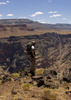
It was a hot day, even on the mountain, and there was a forecast for afternoon rains. We started from the Butterfly trailhead on Mt. Bigelow, from the radio tower parking area. Once we found where the trail left the maintenance road (it's not signed - so you've got to look), we were on our way, switching back down the slope of Bigelow. This part of the trail is unspectacular, but pretty enough and very quiet. The first saddle along the ridge was the junction with the route out to Davis Spring... This saddle was a bit torched and over used, but open and ferny. We headed on toward Incinerator Peak, heading up and down smaller points for another half mile or so. The burn scars in this area are from both the Bullock Fire and the Aspen Fire, and there's a lot of new growth coming back in the form of thorny, stickery and generally pokey shrubs right at hiker level. Luckily, the trail is well used enough to keep it from being a serious navigation problem. It was just hard to keep track of the pooches! From time to time, the views opened up and were wide open to the east, south and north. There were combos of peaks that I'd not seen together before, and it was lots of fun!

Second saddle was the junction with the Incinerator Ridge trail and the Knagge Tr. Sarae and I both want to come back when we've got more mojo and attack the Knagge/Davis Loop. Looks like a good hike with amazing views.

I wasn't timing our trip, so I don't know how long it took us to get to Incinerator Peak. It's not a hard hike, though, and there's some fun but very low-key scrambling up near the peak itself. From the top the views are just incredible, as Sarae already described. We took a few photos, then walked back toward Bigelow. During the whole hike, we were watching storm clouds forming over each of the major ranges around Tucson - including ours. By the time we made it back to the parking area, it was looking decidedly stormy over Lemmon, though Bigelow was still pretty clear.

We drove down the Mt. and got some awesome Yucatan Yum pizza at Eclectic...and I still had time for laundry and housework before my family arrived the next morning. Not a bad way to spend the first part of a lovely weekend!
 Culture
 Culture [ checklist ]
[ checklist ]  HAZ Rides
_____________________
-----------------------------------
Change will not come if we wait for some other person or some other time. We are the ones we've been waiting for. We are the change that we seek.- Barack Obama
 
average hiking speed 1.92 mph
1, 2  Next

WARNING! Hiking and outdoor related sports can be dangerous. Be responsible and prepare for the trip. Study the area you are entering and plan accordingly. Dress for the current and unexpected weather changes. Take plenty of water. Never go alone. Make an itinerary with your plan(s), route(s), destination(s) and expected return time. Give your itinerary to trusted family and/or friends.

helpcommentissue

end of page marker