|
| | | |
| |
|
| Hiking | 8.52 Miles |
2,102 AEG |
| | Hiking | 8.52 Miles | 5 Hrs 47 Mns | | 1.75 mph |
| 2,102 ft AEG | 55 Mns Break | | | |
|
|
| |
| Linked |
|
none
[ show ]
| no linked trail guides |
| Partners |
|
[ show ]
| partners | | Big Horn is a distinctive peak I'd passed many times on I-10, and I've wanted to hike it for a few years. JamesP posted a MeetUp recently, and that was a good excuse to finally get out there. A group of 14(!) met up at 7:30AM in Tolleson to carpool, and we set out from the parking area near the CAP bridge at ~8:45AM, with temps in the upper 30s.
We followed the official route, and it worked well--it's easy to see where the final approach could be much tougher with different route choices. The first two miles were flat, easy hiking across open desert with a few small drainages. We regrouped, then started the first minor climb, regrouped again before the steeper second climb, and continued the pattern most of the way. The middle section following the ridgeline was relatively flat and easy, but the density of the cholla was high, with several areas where it was virtually impossible to avoid stepping on dead spines.
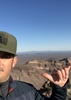
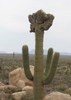
The group reconvened again near the saguaro at the right return before the final approach up to the ridge just east of the peak. That last stretch was steep, loose, and full of fun scrambling as we made the climb. From there, we had one final scramble up the chute on the east side of the summit block. Ten of the 14 made the top (has to be one of the larger groups that's been on the peak at one time), and we took a break on top and enjoyed the views, took some pics, and ate a snack before starting down.
Going down the scree felt tougher than going up, and one person in the group took a scary slide/fall that left him on the edge of a 5-10 foot drop above more cholla...luckily he didn't go over and was fine other than picking up some cholla spines. Good to be back on more solid ground down lower, and we finished ~2:30PM. Fun day and great weather...nice to finally hike Big Horn and meet some new people, including a few HAZ members ( @JamesP and @ScottHika), and thanks to JamesP for organizing. |
| | |
|
|
|
 Route Editor