|
| | | |
| |
|
| Hiking | 4.67 Miles |
960 AEG |
| | Hiking | 4.67 Miles | 3 Hrs 42 Mns | | 1.34 mph |
| 960 ft AEG | 13 Mns Break | | | |
|
|
| |
| Linked |
|
none
[ show ]
| no linked trail guides |
| Partners |
|
[ show ]
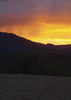
| partners | | We set out to check out the overlook for First water canyon, as I’d never been there. It was a cool overlook, but I saw some cairns that peaked my interest and decided to follow them for a bit. I honestly thought they’d lead to a cool cave or something, so I convinced James to follow them with me! Given that the cairns were prominent and consistent, I was extremely curious where they would lead us. They led us up, up, up and there was some mild bushwhacking and loose rocks, etc. After a few miles, we kinda figured they might have been just a route overlooking all of the first water canyon, so we decided we’d turn back soon. I saw a peak nearby and decided to climb up there to check out the views and I’m so glad we went up there! This random peak offered really cool views all into the canyon, including canyon lake, the superstition Ridgeline and Geronimo head. After enjoying the views for a bit, we headed back but found an alternate route that cut off a nice chunk of what we hiked on the way in. It was a super random day, but I’m glad we got to check out some cool views. I have no idea if we were on an official/unofficial route, but I’m curious to see if anyone knows. Regardless, I always enjoy seeing new views in the Supes and we had it pretty much to ourselves!  |
| _____________________
| Restless between adventures... |
| | |
|
|
|
 Route Editor


 . Rick said he had a sure fired way of catching a ride he said --- Watch Me---
 -- I went the old fashioned route Thumbs Up---
  ( used to work 55 yrs ago, should have put my Uniform on ) Nothing worked, but our own to feet.. Great time today, getting HOT take plenty of water please..