|
| | | Frustum #19 and CHOLLA BM, AZ | | | |
|
|
Frustum #19 and CHOLLA BM, AZ
| | |
| |
|
| Hiking | 4.84 Miles |
968 AEG |
| | Hiking | 4.84 Miles | 4 Hrs 42 Mns | | 2.48 mph |
| 968 ft AEG | 2 Hrs 45 Mns Break | | | |
|
|
| |
| Partners |
|
none
[ show ]
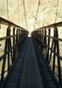
| no partners | | There are two trails in the narrow Pipeline Canyon, located just west of Pleasant Lake.
I started on the Pipeline Canyon Trail, then transitioned to ‘off-trail’ to search for Frustum #19. I then went up atop Pk 2178 to locate CHOLLA BM.
Both the frustum (actually a boundary marker in the shape of a frustum) and the benchmark were set in place in 1924, a few years before the first Pleasant Lake Dam was completed. Neither one is in jeopardy of ‘going underwater’, as they are far above the high waterline.
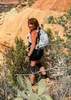
I played alot of ‘dodge-ball’ with healthy cholla on my way up a ridge to the frustum area.
Once atop the little sloping ridge, I finally located Maricopa/Yavapai Boundary Marker #19, hiding in the low morning sun. For being so close to humanity, I was impressed with its good condition. One can see where attempts were made to dislodge the three plaques from the frustum. The plaques ‘held strong’ and are in excellent shape. The concrete around the plaques display the brunt of the ill-fated attempts to dislodge those plaques.
Next was, ‘go find the benchmark’, that was set in association with this frustum. I had the Lat/Long for the BM, so that was no problem. CHOLLA Triangulation Station (1924), is located atop Pk 2178, just 1/3rd mile up the ridge to the northwest from Frustum #19. The surveyors must have been impressed with all the cholla plants, ergo the BM’s name. No reference or azimuth marks were set.
CHOLLA BM is literally located at the end of, and in the middle of, another trail - Yavapai Point Trail. CHOLLA BM is in very good shape, considering its location.
I left Pk 2178 off-trail, transitioned back to the Yavapai Point Tr, then to the Pipeline Canyon Tr.
This was a fun, easy hike with great views of the second largest reservoir in Arizona.
Plus I located the things I set out to locate. All good things. |
| _____________________
Not All Those Who Wander Are Lost
J.R.R.TOLKIEN |
| | |
|
|
|
 Route Editor