|
| | | |
| |
|
| Backpack | 12.00 Miles |
200 AEG |
| | Backpack | 12.00 Miles | 2 Days | | |
| 200 ft AEG | | 24 LBS Pack | | |
|
|
| |
| Linked |
|
none
[ show ]
| no linked trail guides |
| Partners |
|
none
[ show ]
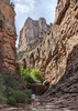
| no partners | | My first visit to Aravaipa Canyon - and first backpack - in several years.
I had a two-night permit, but thought from the beginning that I might just stay one.
I was excited to finally try my *almost* ultralight kit that I've been assembling over the past few years. I'm a bit of a gear geek.
Short version:
Great conditions, new friend, wonderful time with a bit of "epic" at the end.
Long version:
Since buying a proper capable 4WD vehicle last year, I have been looking forward to driving all the way to the Turkey Creek TH. For some reason I really resented hiking that extra 1.8 miles or so each way. It's easy and pretty enough, but I just wanted to get to the main attraction right off the bat - plus by the end of that walk out to the 2WD TH, I was already hot and dry, and felt like I had lost all the refreshment I gained in the Canyon.
I stopped at Bear Canyon to sign in. There were two trucks parked there, and looking at the log I could see that a couple parties were due out, and that just one person had signed in that day - also with a three day permit.
So the drive in was nice - the creek crossings were all pretty straightforward, and I squeezed my truck in next to two others.
I chatted with four men who were leaving after their two nights - sounded like they had a great time. They also told me that another solo female hiker had just started 15-20 minutes before me.
As I entered the creek, I was super happy with the weather, the water temperature, my footwear and the weight of my pack - everything felt fantastic and I cruised along happily enjoying the scenery and the birds.
I was following in the unknown hiker's footsteps often, and wondering when I would catch up ... the guys said it was her first visit so I thought she might go slowly and stop to look around often - but I eventually decided she must be a pretty fast hiker.
Shortly before reaching Parsons Canyon I crossed paths with a man and two women headed out. They gushed about how great it was - they had some amusing turkeys around camp and saw a bear, and had just enjoyed a nice swim in a deep pool ... and they had met the woman ahead of me.
When I reached the large shelf/camping area just east of the Hell Hole entrance, I saw a backpack, poles and other gear sitting there - but no person. I met her shortly afterwards, just downstream and we chatted - she asked what I thought about the spot her stuff was in and where I was headed ... told her Booger Canyon area, then dayhike down to HCC/Virgus area the next day.
Right after that, I saw a most unexpected bird - a beautiful male Cinnamon Teal! I flushed him accidentally and he flapped away awkwardly, so I was worried that he was injured ... thinking I'm going to have to try and catch him, then pack him out of here and take him to rehab, and there goes my trip - but I would have absolutely done it and felt good about it, if needed. Luckily, after observing him for another minute or two, he took off and flew perfectly downstream and into the woods (still odd).
30 minutes later I was having a nice lunch break when Tamara came around the bend and caught up. She asked if I minded her joining me for the hike and I said that would be fine ... we agreed to camp nearby but not exactly together, since I need my space. She turned out to be a very pleasant hiking partner, and I was glad we teamed up.
We dropped our packs at my normal small site across from Booger and went scouting for another nearby spot. We looked briefly across the creek , where I had read that there was another site - but if it's there, it's buried in deep grass. Next we went downstream to find the nice site I had found last time I was at Booger ... we found it just 200-300 yards downstream, and it's really nice - so I let her have it and I used the small, unremarkable site that I was used to.
Neither one of us slept much due to the Canyon Tree Frogs singing at the approximate decibel level of a rock concert - and in my case, also due to my new sleeping pad which almost drowned out the noise of the frogs ... it was like trying to go to sleep on a giant bag of potato chips. The next day I was ready to give that pad away to the first person I crossed paths with.
The next morning she headed downstream before me, and I caught up with her at HCC. We both agreed that we would hike out that day instead of staying another night ... we were both beat due to lack of sleep, and she was at the end of a week of hiking and camping all over Southern AZ.
We hiked 8 miles on Wednesday and it was lovely. The water was perfect, the weather was great, and the wind only gusted occasionally. It was Tamara's first visit to Aravaipa, and she got a good first taste of the place - she was blown away by the beauty, and I'm betting she will return regularly.
So we arrive at my truck at the Turkey Creek TH at last, and we are so happy to be done - not knowing we still had a pretty big obstacle ahead of us! We were in my truck, driving her back to her truck at the 2WD trailhead, I was driving along chatting and looking at her when she gestured ahead and said "look at that" - she said it so casually that I expected to see a turkey in the road, or some hikers or something ... I did NOT expect to see a quite large tree down across the road!
I pride myself on being prepared, so I had a saw and hatchet - but just tiny ones ... not meant for dealing with a tree this large (and solid! The thing was alive - I don't even know why it fell).
We were pretty determined to get out of there, though - and we didn't know if anyone knew about it, or when it would be dealt with by someone with a chainsaw. So we went to work. I'll tell you this - my new friend is stronger than she looks, and has a great attitude! In just over an hour, we had cut and moved two major branches and cleared the smaller ones ... we were just about to squeeze the truck through when I heard a side-by-side approaching from the other side. It was a guy from the Nature Conservancy, with a chainsaw to clear the tree. After we were 99.9% done.
We just had to laugh. And that guy was super impressed with what we had accomplished with the tools we had! We finally got back to Bear Creek and were airing up her tires a bit when that guy came by and stopped to check with us that there were no other vehicles at Turkey Creek - he was going to leave the rest of the tree until the next day - and to tell us again how tough we are ... I told Tamara "That guy's going to tell stories about us!"
I finally made it home just after 8pm, and Tamara texted me a couple hours later to let me know that she had arrived safely back home in Tucson. All's well that ends well ... and it was certainly memorable! |
| _____________________
| | |
|
|
|
 Route Editor