username
X
password
register
for free!
help
ArticlesGuidesRoutes
 
Photosets
 
 Comments
triplogs   photosets   labels comments more
Wild Burro Trail - Lake Pleasant - 6 members in 12 triplogs have rated this an average 3.2 ( 1 to 5 best )
12 triplogs
login for filter options
Jan 29 2025
avatar

 Routes 70
 Photos 3,081
 Triplogs 601

70 male
 Joined Feb 10 2019
 Cave Creek, AZ
Wild Burro Trail - Lake PleasantPhoenix, AZ
Phoenix, AZ
Hiking avatar Jan 29 2025
LosDosSloFolksTriplogs 601
Hiking4.21 Miles 417 AEG
Hiking4.21 Miles
417 ft AEG6 LBS Pack
 
Linked   none no linked trail guides
Partners none no partners
Route Scout Route Recorded  on Route Scout | Pop | Map | Popup | MapDEX
Dreary and drizzly morning but I still wanted to get out of the house. I drove down the road to Lake Pleasant and did the out and back on the Wild Burro Trail with the hopes of running into some burros. I hiked this trail exactly one year ago to the day and saw dozens of the cute fur balls back then.

The light rain at the start of the hike must of had them looking for cover as I didn't see any until about one mile in. A family unit of four with one very young one greeted me with braying. When they saw I had carrots they became much less upset and judgemental. The poor adolescents face was covered with cockleburrs but there was no way to help him out short of anesthesia. He didn't seem to mind though.

I finished the hike without seeing any other critters so after my Out-N-Back hike I went to In-N-Out for a late lunch. The skies opened up just as I was leaving Lake Pleasant Park. Lucky timing.
 Fauna
 Fauna [ checklist ]
[ checklist ]  Wild Burro
 Named place
 Named place [ checklist ]
[ checklist ]  Lake Pleasant

water 1 out of 5water 2 out of 5water 3 out of 5water less than max Lake Pleasant 51-75% full 51-75% full
_____________________
"If you wait, all that happens is you get older"
 
Feb 09 2024
avatar

 Guides 110
 Routes 2,246
 Photos 8,982
 Triplogs 2,600

45 female
 Joined Dec 24 2007
 Ahwatukee, AZ
Beardsley Trail - Lake PleasantPhoenix, AZ
Phoenix, AZ
Hiking avatar Feb 09 2024
LindaAnnTriplogs 2,600
Hiking13.95 Miles 1,394 AEG
Hiking13.95 Miles   4 Hrs   43 Mns   3.11 mph
1,394 ft AEG      14 Mns Break
 
1st trip
Linked   linked  
Partners partners
trekkin_gecko
Route Scout Route Recorded  on Route Scout | Pop | Map | Popup | MapDEX
The trails by Lake Pleasant fit our criteria, so Kelly and I opted for two that were new-to-us. Got started a little after 0700. Cool temps, no breeze, few clouds. Lots of snow visible on the Bradshaws. Headed north on Beardsley Trail. Saw one bird at the water where we started, not sure what is was—grey, at least a 3’ wingspan—but I was already wearing sunglasses in the semi-darkness, so I didn’t get a good look.

The trail was easy as it meandered to the northwest. Not much in the way of views. Made a side trip on Frog Tanks Trail, but we’re not quite sure if we did the entire thing. Then continued north on Beardsley. Saw six burros.

North on Wild Burro. A little mud in places, but not bad. Views of the lake and mountains. No burros.

Once at the north end of Wild Burro, we turned around and retraced our steps back south. Saw four friendly burros on Beardsley, cute juveniles, who were probably expecting us to hand out carrots. Saw four hikers.

Lots of green out there. Some good sections of saguaros. Nice hike, nice day, and good conversation. Thanks, Kelly, for being willing to skip Papago for a day!
_____________________
Stop crying and just go do the hike.
  1 archive
Feb 09 2024
avatar

 Guides 10
 Routes 673
 Photos 7,281
 Triplogs 4,660

67 female
 Joined Nov 17 2008
 phoenix, az
Beardsley Trail - Lake PleasantPhoenix, AZ
Phoenix, AZ
Hiking avatar Feb 09 2024
trekkin_geckoTriplogs 4,660
Hiking13.69 Miles 1,394 AEG
Hiking13.69 Miles   4 Hrs   41 Mns   3.06 mph
1,394 ft AEG      13 Mns Break
 
1st trip
Linked   linked  
Partners partners
LindaAnn
Route Scout Route Recorded  on Route Scout | Pop | Map | Popup | MapDEX
linda suggested lake pleasant for some easy mileage on smooth trails
i was out this way a couple years ago with @johnlp
we decided on doing beardsley and wild burro out and back, both trails new to us
got going from the south end of beardsley around 0710
cool temps, not much wind
trail was a bit damp through morgan wash and over the bridge
passed through several gates along the way
there was a short stretch on old lake pleasant road, then the trail continued west of the road
we saw several burros in this section
nice view of the snow covered bradshaws
we added the short segment of frog tanks trail, which led to a nice view of lake pleasant at a small trailhead
soon came to a camping area and the intersection with wild burro
more views of the lake
we turned around at the pipeline canyon trailhead and returned the same way
saw two cute little burros once back on beardsley, right on the trail
they got a few pets, but really wanted a snack
finished up before noon
this was a good choice, linda, thanks for suggesting it
miles went fast with good conversation, and it was fun to do something new
_____________________
hazhole
 
Jan 29 2024
avatar

 Routes 70
 Photos 3,081
 Triplogs 601

70 male
 Joined Feb 10 2019
 Cave Creek, AZ
Wild Burro Trail - Lake PleasantPhoenix, AZ
Phoenix, AZ
Hiking avatar Jan 29 2024
LosDosSloFolksTriplogs 601
Hiking4.28 Miles 377 AEG
Hiking4.28 Miles
377 ft AEG6 LBS Pack
 
Linked   none no linked trail guides
Partners none no partners
Route Scout Route Recorded  on Route Scout | Pop | Map | Popup | MapDEX
Stopped off at Lake Pleasant on my way out to golf at Quintero Golf Course. I had a large bag of past date carrots to get rid of and I found plenty of takers on this trail. I've done many hikes on the west side of Castle Hot Springs Road in the Hieroglyphic Range but never on these close to the lake tourist type trails.

Paid my entry fee at the gate and then headed north on the Wild Burro Trail. Within 5 minutes I found the first of maybe 25-30 different "wild" burros. Most were skittish, but on my return route word must have spread among the burro community that I had carrots. They converged on me from everywhere and at one point they were walking up to me on the trail and also coming up from behind. Yeah, they're wild all right. : wink : It turned into a big old petting zoo. Even after all the carrots were gone they followed me around for quite a while. Burros are good people.
 Fauna
 Fauna [ checklist ]
[ checklist ]  Wild Burro

water 1 out of 5water 2 out of 5water 3 out of 5water 4 out of 5 Lake Pleasant 76-100% full 76-100% full
Levels are down about 20' from watermark.
_____________________
"If you wait, all that happens is you get older"
 
Jan 14 2023
avatar

 Guides 27
 Routes 670
 Photos 12,111
 Triplogs 857

56 male
 Joined Jul 05 2006
 Mesa, AZ
Cottonwood Trail - Lake PleasantPhoenix, AZ
Phoenix, AZ
Hiking avatar Jan 14 2023
DarthStillerTriplogs 857
Hiking10.57 Miles 1,434 AEG
Hiking10.57 Miles   4 Hrs   39 Mns   2.28 mph
1,434 ft AEG      1 Min Break
 
1st trip
I hiked almost all of these trails about 5 years ago except for the Cottonwood Trail, so it seemed like the right time to go back and hike that and not be bored by hiking the other trails for a 2nd time.

The Cottonwood Trail has a trailhead on the north end, but I opted to hike from the south end since it has restrooms and a bench to use while I changed shoes afterwards. The first 20+ minutes I hiked in the dark with a headlamp, despite the hour plus drive from my house. Just short of the north trailhead is an unmarked trail that crosses the Cottonwood Trail that is marked by "AREA CLOSED" signs. So I ignored those and hiked the north segment to Castle Springs Road and then the south segment to a wash that intersected another wash that led back to the Cottonwood again. Nice little side excursion to mix it up a bit.

I was surprised to see how low Lake Pleasant is despite all the recent rain. The views from Yavapai Point made this obvious. I hiked up to there and then down the Pipeline Canyon Trail and a bit down the Wild Burro Trail before turning around. The bridge crossing on Pipeline Canyon looks beyond repair, but no longer relevant.

Once I was no longer on the Wild Burro Trail and on the Pipeline Canyon Trail, I saw a group of wild burros. Lots of hikers later in the day. Cloudy skies made for not great lighting for pictures, but kept the temperature comfortable.
_____________________
 
Nov 26 2020
avatar

 Guides 9
 Routes 33
 Photos 780
 Triplogs 4,634

44 male
 Joined Nov 25 2008
 Scottsdale, AZ
Wild Burro Trail - Lake PleasantPhoenix, AZ
Phoenix, AZ
Run/Jog avatar Nov 26 2020
BoonemanTriplogs 4,634
Run/Jog12.50 Miles 959 AEG
Run/Jog12.50 Miles   1 Hour   48 Mns   6.94 mph
959 ft AEG
 no routesno photosets
1st trip
Partners none no partners
Ran and out and back from the Wild Burro trailhead to Pipeline Canyon TH, then and out and back to the Beardsley TH.
_____________________
 
Nov 10 2019
avatar

 Guides 8
 Routes 12
 Photos 1,918
 Triplogs 662

39 female
 Joined Dec 02 2009
 Grand Canyon
Wild Burro Trail - Lake PleasantPhoenix, AZ
Phoenix, AZ
Hiking avatar Nov 10 2019
HippyTriplogs 662
Hiking4.83 Miles 592 AEG
Hiking4.83 Miles   1 Hour   42 Mns   2.87 mph
592 ft AEG      1 Min Break
 
no photosets
1st trip
Linked   linked  
Partners none no partners
Route Scout Route Recorded  on Route Scout | Pop | Map | Popup | MapDEX
Parked at Wild Burro Day Use Area hiked out the almost 2 miles to the southern Pipeline Cyn Trailhead, went down to the water and back on pipeline then back to the car.

Easy almost 5 miles this morning.
Loaded up my backpack with 6 liters of water and my two sleeping bags to simulate some weight.
Getting my foot use to weight again is turning out to be a very easy process.
_____________________
Canyon Freak Adventures!
 
Nov 30 2018
avatar

 Guides 117
 Routes 338
 Photos 11,399
 Triplogs 894

63 male
 Joined Dec 20 2010
 Sunnyslope, PHX
Wild Burro Trail - Lake PleasantPhoenix, AZ
Phoenix, AZ
Hiking avatar Nov 30 2018
kingsnakeTriplogs 894
Hiking5.80 Miles 593 AEG
Hiking5.80 Miles   2 Hrs   10 Mns   2.68 mph
593 ft AEG
 no routes
1st trip
Partners none no partners
I avoid hiking high elevations, like Strawberry Mountain, in the winter. Couple of inches of snow up there the last few days. No thanx. ✋

In previous winters, I’ve ranged far & wide, particularly to the Arizona Outback, in search of interesting hikes at lower elevations.

Last winter I started doing more hikes close to Phoenix: What I term “Locals’ Hikes“.

As our 10th anniversary was the night before, and I’d had a wee bit of champagne, I decided to hike Wild Burro Trail, Pipeline Canyon Trail and Cottonwood Trail, but only one way (north), rather than do an out & back. 🥂

Lake Pleasant’s water levels ( http://pleasant.lakesonline.com/Level/ ) are 5-9 ft. below recent years, but the high water line is much higher, and marked by a distinct change in vegetation. I’m guessing the high water level is 30 ft. above the current depth of 1,664 ft. If Lake Pleasant was another 30 ft. higher, Wild Burro Trail would be along the shoreline in many spots. Instead, the shore is a couple hundred yards off. Still, it has the only decent lake views.

The high water line of Pipeline Cove extends a quarter mile west of the trail, which you can see on satellite view. There used to be a floating bridge there, but flash floods tore it from its moorings. It may not look it, but water has a tremendous amount of force, enough even to roll the bridge’s support blocks down channel. Pipeline Canyon Bridge’s wreckage, twisted with brush & guy lines, is 100 yds. away from its original location.

Because Lake Pleasant is low, Pipeline Cove is a dry crossing.

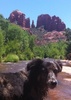
As I descended towards Cottonwood Trailhead, while looking out at the last sliver of Lake Pleasant view, I was startled when a previously unseen wild burro snorted me. I could see his herd moving in the palo verde.

There would be some shade on Cottonwood Trail, but shade was the last thing I needed as the sky was nearly 100% overcast. (It was so foggy at 8:30 a.m., that if those burros had been in the middle of Castle Hot Springs Rd., I very well may have hit them.)

Due to the sporadic sunshine, taking decent photos on my 💩 pocket camera was difficult. There’s limited photo ops, anyway, on Lake Pleasant’s trails, particularly given the low water levels and people’s understandable reluctance to be on the water with temps in the 50s. Without flowers and bridge wreckage, I would have had nothing.

Despite the hike being short, and with minimal elevation gain, I had unusually sore quads on Saturday morning. 🤔

Hike Video: https://vimeo.com/494789451
 Fauna
 Fauna [ checklist ]
[ checklist ]  Wild Burro
 Culture
 Culture [ checklist ]
[ checklist ]  Bridge  Cag Shot
 Named place
 Named place [ checklist ]
[ checklist ]  Lake Pleasant
wildflower observationwildflower observationwildflower observationwildflower observationwildflower observation
Wildflowers Observation Light
Brittlebushgoing nuts.
_____________________
http://prestonm.com : Everyone's enjoyment of the outdoors is different and should be equally honored.
  1 archive
Apr 15 2018
avatar

 Guides 69
 Routes 37
 Photos 3,010
 Triplogs 2,387

55 male
 Joined Oct 24 2010
 Phoenix,Az
Wild Burro Trail - Lake PleasantPhoenix, AZ
Phoenix, AZ
Run/Jog avatar Apr 15 2018
mt98dewTriplogs 2,387
Run/Jog12.90 Miles 168 AEG
Run/Jog12.90 Miles   2 Hrs   36 Mns   4.96 mph
168 ft AEG
 no routesno photosets
1st trip
Linked   linked  
Partners none no partners
Posting this under Wild Burro Trail, because it was my intended objective, but actually started from the Breardsley TH. Got started around 6am. I was surprised at how chilly it was as I went through the vegetated River bottom at the beginning of the hike. I would guess 10 degrees cooler compared to anywhere else on the trail (this would include the TH which was only minutes away). I had done Beardsley once before, last year, as a hike with a planned trail description which I never got around to. I remember it being a nice, but "long" trail. Today I jogged it and found it much more entertaining. It is smooth for running (or biking) with just enough up and down to challenge me and then give me "recovery time". The trail is fairly isolated, not really seeing the lake until the very end. For the last half of the Beardsley there is a road that parallels the it, so there is the occasional sounds of cars speeding by. The Beardsley trail ends where the Wild Burro Trail starts. The Wil Burro has a little bit of a climb at the beginning and at the end, but the middle part is nice and flat follows the contours of the Lake Pleasant shoreline. Because of this, there is a lot more activity "around" the trail - boats motoring on the water, campers in their pup tents, fishermen dotting the shoreline and vehicles moving along the roads that are in constant view. Still, it was a different experience jogging next to a body of water. Saw the obligatory wild burros on the Wild Burro Trail (5 of them) and a lone, noisy one on the Beardsly. Passed one hiker and one runner on the Wild Burro, but otherwise had the trails to myself. It was nice to finally do some Lake Pleasant trails ....I'd been wanting to crack the nut for a long time.
_____________________
 
Nov 24 2017
avatar

 Guides 3
 Routes 7
 Photos 514
 Triplogs 94

43 male
 Joined May 21 2004
 Phoenix, AZ
Wild Burro Trail - Lake PleasantPhoenix, AZ
Phoenix, AZ
Hiking avatar Nov 24 2017
SunDevil3Triplogs 94
Hiking2.02 Miles 168 AEG
Hiking2.02 Miles   1 Hour   45 Mns   1.35 mph
168 ft AEG      15 Mns Break12 LBS Pack
 no routes
1st trip
Linked   none no linked trail guides
Partners none no partners
Family hike with the wife, kids, and dog. Our main goal was to spot some of the trail's namesake wild burros for the first time and I am pleased to say we accomplished our goal. We actually started from the Pipeline Trailhead (as parking was scarce at the first spot i tried) and just headed on the slow steady downhill that quickly crosses the road before skirting the side of the on the hills on it's descent.

The burros were up on the ridge in several small groups and a couple of loaners off grazing on their own. I was surprised at how big a few of them were-- sort of skinny and lanky but much taller than I had imagined-- much closer to horse-height (however many hands that equal, I am not sure.)

We hiked until the sun and terrain became too oppressive for my youngest daughter and then turned back-- waving a farewell to a bunch of jack asses up on the hill as we went :)
 Fauna
 Fauna [ checklist ]
[ checklist ]  Wild Burro
_____________________
"Being unselfish is a natural high, like hiking or paint thinner."
- Homer J Simpson
 
Feb 12 2017
avatar

 Guides 27
 Routes 670
 Photos 12,111
 Triplogs 857

56 male
 Joined Jul 05 2006
 Mesa, AZ
Pipeline Canyon TrailPhoenix, AZ
Phoenix, AZ
Hiking avatar Feb 12 2017
DarthStillerTriplogs 857
Hiking10.40 Miles 1,319 AEG
Hiking10.40 Miles   4 Hrs   30 Mns   2.31 mph
1,319 ft AEG
 
1st trip
Partners partners
JimmyLyding
Jim was back in town for a wedding and wanted to do a hike. I also had friends from Pgh in town for the Pens game Sat nite, but I was determined to get all the socializing in for one weekend. After getting home later and an early wake up, we started on the trail at 7am.

We took the Pipeline Canyon Trail straight to the Yavapai Pt. Trail and took that out and back and then took the shortcut connecting trail back to the Pipeline Canyon Trail and then to the Wild Burro Trail, down to where I left off last month from the Beardsley Trail. When we started, there was a warning sign that the Pipeline Canyon Trail was closed as the one cove where the water was higher and the bridge was out. Once we got to that point, we started to follow the contours of the land around the cove and encountered a faint trail that seemed to be made from others with same intent as us, to get around the water anyway. At one point in the corner of a ravine we even saw a cairn. The crossing of the big cove was a bit tricky, but nothing worse than anything we've encountered in the Sierra Anchas or elsewhere in the TontoNF.

the bushwhack slowed us down a bit so that when we didn't have enough time to finish the Cottonwood Trail, which I had wanted to do. 2 miles less than planned, but finishing at 11:30am seemed like a good idea since Jim had to catch a plane back to Silicon Valleyland, and I had several chores to finish at home.

weather was cool and cloudy, warmed up later with some sun breaking through. the views up north were nice, lots of infrastructure near the lake mixed with closer views.
 Fauna
 Fauna [ checklist ]
[ checklist ]  Wild Burro
_____________________
 
Oct 29 2016
avatar

 Routes 14
 Photos 187
 Triplogs 17

49 female
 Joined Dec 26 2013
 Anthem, AZ
Wild Burro Trail - Lake PleasantPhoenix, AZ
Phoenix, AZ
Hiking avatar Oct 29 2016
laissezfaireTriplogs 17
Hiking3.59 Miles 303 AEG
Hiking3.59 Miles   1 Hour   59 Mns   2.27 mph
303 ft AEG      24 Mns Break15 LBS Pack
 
1st trip
Linked   none no linked trail guides
Partners none no partners
Still a little toasty out at the end of October but still a good view of Lake Pleasant. The trail starts at the Wild Burro Day Use Area off Desert Tortoise Road in Lake Pleasant Regional Park. The hike is all along the edge of the lake or all along the edge of the empty lake bed depending on the lake's water levels at the time. You are likely to see actual wild burros on your hike so keep your camera handy. The trail is not very difficult at all and only about 2 miles one way but if you continue on to the Pipeline Canyon Trail for about another 1.4 miles, there's a cross over to the more challenging Yavapai Point that takes you to the top of a very scenic overlook with a fantastic view of the lake. Wild Burro is good for new hikers, those in need of a short jaunt or as a jump off point for the other trails that lead off from it.
 Fauna
 Fauna [ checklist ]
[ checklist ]  Wild Burro
 Named place
 Named place [ checklist ]
[ checklist ]  Lake Pleasant
_____________________
 
average hiking speed 2.29 mph

WARNING! Hiking and outdoor related sports can be dangerous. Be responsible and prepare for the trip. Study the area you are entering and plan accordingly. Dress for the current and unexpected weather changes. Take plenty of water. Never go alone. Make an itinerary with your plan(s), route(s), destination(s) and expected return time. Give your itinerary to trusted family and/or friends.

helpcommentissue

end of page marker