|
| | | |
| |
|
| Hiking | 15.60 Miles |
1,072 AEG |
| | Hiking | 15.60 Miles | 7 Hrs 11 Mns | | 2.91 mph |
| 1,072 ft AEG | 1 Hour 49 Mns Break | | | |
|
|
| |
| Linked |
|
none
[ show ]
| no linked trail guides |
| Partners |
|
none
[ show ]
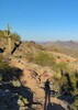
| no partners | | Mom and I went out for a fun day hike to kick off the Labor Day weekend. This was our first official section of AZ trail that was have completed. We've hiked parts of other segments, including in the Grand Canyon, Cabin Loop trail, Mazatzals, and Superstitions, but this was the first passage we've completed in its entirety.
Here are some of the details from the trip, which made a great day trip from Phoenix to escape the heat!
6:30 AM: Departure from Phoenix...a little later than we hoped, but a hearty breakfast goes a long way on a lengthy hike like this.
We never actually looked at how to get to the trailhead, so we ended up taking the adventurous way, exiting I-17 at Rocky Park road and taking a combination of forest roads (127C, 127, 91, and maybe a couple others) to get to Lake Mary Road. Good thing we had a high clearance vehicle (2001 Chevy Suburban), as some of those roads were "off the beaten path". Especially 127C was very rough, with lots of rocks. It was also very narrow, sometimes scraping branches on both sides of the SUV and narrowly escaping boulders with the tires. Little did we know we could have just exited at Stoneman Lake road and had a smooth 17 mile graded road and then completely paved after that!
After dropping my mom off at Gooseberry Springs trailhead for the AZ trail, I drove up to Mayflower springs, then biked the 13 miles back to our starting point. After locking my bike in some thick forest to prevent theft, we began our 14.8 mile journey to Mayflower Spring.
The trail itself is in very good condition, mostly flat consisting of dust and pine needles. The latter half was a little rockier, with more terrain as well to make the hike more interesting. Looking back on it, we'd describe the first half as a "walk in the park" and the second half as a "hike." The first several miles of trail were close to Lake Mary road, as well as some forest roads in the area, so there was quite a bit of traffic noise. Definitely not the "wilderness" experience I often try for when hiking. Of course, it was a holiday weekend in an area famous for off roading, ATVs, etc.
The most interesting part of the hike was the "lake", i.e. 9486J tank, which was quite nice when the sun came out and made brilliant colors. The other excitement was the two informational signs put up by the Arizona State Parks association talking about the lumber industry and their railroads.
7:00 PM: Arrival at Mayflower Springs road crossing where the vehicle was parked. The end of a super long super fun hike, and just the beginning of our exploration of the AZ trail!  |
  |
9486J Tank |
1-25% full |
1-25% full |
| |  A little muddy, with some grass growing in it, but plenty to rely upon for filtering. A little muddy, with some grass growing in it, but plenty to rely upon for filtering. |
|
Double Springs |
Gallon + per minute |
Gallon + per minute |
| | | Plenty of water in the creek at the campground. Seemed like they were maybe pumping the water from a well to feed the creek...couldn't quite tell. Regardless, even if that was dry, there's water at the campground faucets. |
|
Navajo Spring |
Gallon + per minute |
Gallon + per minute |
| | | Nice clean water from the faucet | | | |
|
|
|
 Route Editor


 Fairly easy so we were able to knock out mileage at a strong clip while still taking it all in.