username
X
password
register
for free!
help
ArticlesGuidesRoutes
 
Photosets
 
 Comments
triplogs   photosets   labels comments more
Ballantine to Boulder Flat - 39 members in 142 triplogs have rated this an average 3.3 ( 1 to 5 best )
1, 2, 3, 4, 5 ... 8  Next
142 triplogs
login for filter options
Jan 18 2025
avatar

 Guides 12
 Routes 192
 Photos 863
 Triplogs 356

42 male
 Joined Nov 30 2015
 Phoenix, AZ
Ballantine Cabin & CorralPhoenix, AZ
Phoenix, AZ
Run/Jog avatar Jan 18 2025
ShatteredArmTriplogs 356
Run/Jog8.35 Miles 2,205 AEG
Run/Jog8.35 Miles   3 Hrs   9 Mns   2.74 mph
2,205 ft AEG      6 Mns Break
 no routesno photosets
1st trip
Partners none no partners
Decided to head back the Ballantine area after a long absence, with the goal of getting to the cabin, and a stretch goal of doing the boulders loop. Turns out I'm really out of shape, because I was feeling pretty tired by the time I got to Boulder Flat, and figured there's no way I'd actually do the boulders. The fire hit some of the lower parts of the trail pretty hard, but it also did a pretty good job clearing away some of the thornier vegetation.

The catclaw got pretty bad right before the cabin - which it turns out had burned down in on of the recent fires. Bummer, I never got to see it! Poked around for a few minutes, then started back.

On the way down, I actually saw a group of a few hikers. That's a first for me on Ballantine Trail.
_____________________
  1 archive
Jun 15 2024
avatar

 Guides 27
 Routes 669
 Photos 12,096
 Triplogs 856

56 male
 Joined Jul 05 2006
 Mesa, AZ
Ballantine to Boulder FlatPhoenix, AZ
Phoenix, AZ
Hiking avatar Jun 15 2024
DarthStillerTriplogs 856
Hiking9.97 Miles 2,206 AEG
Hiking9.97 Miles   6 Hrs   30 Mns   1.62 mph
2,206 ft AEG      20 Mns Break
 
Partners none no partners
Went in 5 miles and turned around. I almost hiked this 2 weeks ago and I'm very glad I didn't due to the fire. 5 miles in it looked like the burn ended there but at my turnaround point it was still burnt at the trial. The last quarter mile before I turned around I lost the trail due to the burn. I could see further up where I stopped where the trail went. Past Boulder Flat the trail was much fainter and harder to follow.

The heat wasn't too bad, but I'm still very slow going uphill, even with moderate warmth. Once I stopped for lunch, it wasn't hot at all. By the time I got back to the car it was hot, but I was going downhill.

Saw a desert tortoise halfway up. He was dusty but still seemed healthy and moved pretty well. Interesting to see how this area looks so recently after a burn. It also seemed like the safest area to hike with the recent wildfires around and still get some elevation gain with a bit of relief from the lower valley heat.
 Fauna
 Fauna [ checklist ]
[ checklist ]  Desert Tortoise
_____________________
 
Nov 15 2023
avatar

 Triplogs 71

male
 Joined Jan 23 2025
 Seattle, WA
Ballantine to Boulder FlatPhoenix, AZ
Phoenix, AZ
Hiking avatar Nov 15 2023
dhelderTriplogs 71
Hiking6.50 Miles 1,380 AEG
Hiking6.50 Miles
1,380 ft AEG
 no routesno photosets
1st trip
Linked   none no linked trail guides
Partners none no partners
 
Feb 18 2023
avatar

 Guides 59
 Routes 1,100
 Photos 1,191
 Triplogs 1,290

male
 Joined Jan 01 2023
 Arizona
Ballantine to Boulder FlatPhoenix, AZ
Phoenix, AZ
Hiking avatar Feb 18 2023
pseudalpineTriplogs 1,290
Hiking7.14 Miles 1,634 AEG
Hiking7.14 Miles   2 Hrs   54 Mns   2.64 mph
1,634 ft AEG      12 Mns Break
 
no photosets
Partners none no partners
Route Scout Route Recorded  on Route Scout | Pop | Map | Popup | MapDEX
Trail is overgrowing again (slightly). Still too early for wildflowers.
  3 archives
Jan 21 2023
avatar

 Guides 10
 Routes 673
 Photos 7,281
 Triplogs 4,660

67 female
 Joined Nov 17 2008
 phoenix, az
Ballantine Cabin & CorralPhoenix, AZ
Phoenix, AZ
Hiking avatar Jan 21 2023
trekkin_geckoTriplogs 4,660
Hiking11.47 Miles 2,611 AEG
Hiking11.47 Miles   4 Hrs   45 Mns   2.69 mph
2,611 ft AEG      29 Mns Break
 
Partners partners
johnlp
hit john up to hike ballantine trail to the cabin
hadn't been on this hike in nine years
we got going around 0700 or so
chilly temps, but fine going uphill
took the southern piece of pine creek loop, then ballantine to boulder flat
up and over the ridge toward the cabin
we had planned to add some mileage on pipeline trail but ended up on a motorcycle? trail that went northwest to pine creek
we turned around there since we didn't see any way to stay dry crossing the creek
took a little break at the cabin on the return
makes for a nice destination
back through the scenic boulder terrain, finishing on the other half of pine creek loop
i like this hike although i find some of the footing challenging
thanks for hiking and for driving john - good times :)
it's been fun revisiting some hikes i haven't done in a few years
_____________________
hazhole
 
Jan 21 2023
avatar

 Guides 1
 Routes 14
 Photos 7,202
 Triplogs 5,208

68 male
 Joined Mar 16 2008
 chandler,az
Ballantine Cabin & CorralPhoenix, AZ
Phoenix, AZ
Hiking avatar Jan 21 2023
johnlpTriplogs 5,208
Hiking11.47 Miles 2,693 AEG
Hiking11.47 Miles   4 Hrs   45 Mns   2.69 mph
2,693 ft AEG      29 Mns Break
 no routes
Partners partners
trekkin_gecko
Kelly suggested hiking Ballentine to the cabin, and maybe adding on some extra with the Pipeline trail.
We got started to chilly temps, with some frost and ice in places. Once we got to the cabin it was nice and warm.
We hiked down to Pine Creek on a motorcycle trail instead of Pipeline. The creek was flowing good. Very scenic. In fact, the whole hike is scenic. Mountains, boulders, saguaros, and lots of running water.
Good day. Thanks Kelly. :)
 Named place
 Named place [ checklist ]
[ checklist ]  The Boulders
wildflower observationwildflower observationwildflower observationwildflower observationwildflower observation
Wildflowers Observation Isolated
_____________________
“Good people drink good beer.” Hunter S Thompson
 
Jan 19 2023
avatar

 Guides 1
 Routes 23
 Photos 579
 Triplogs 45

male
 Joined Jan 10 2014
 Fountain Hills,
Ballantine Cabin Lasso Loop, AZ 
Ballantine Cabin Lasso Loop, AZ
 
Hiking avatar Jan 19 2023
GeeEssTriplogs 45
Hiking8.00 Miles 2,195 AEG
Hiking8.00 Miles   4 Hrs   45 Mns   1.68 mph
2,195 ft AEG
 
1st trip
Partners none no partners
Just wanted a bit of a workout today without getting too cold or driving too far, and this seemed to fit the bill. Nice flat parking area immediately off of SR 87, so easily accessible to all, and a reasonably well-maintained trail nearly all the way to the cabin. All in all, a bigger workout than I was expecting, and more time consuming as well, largely due to the uphill portions of the trail. Plenty of cactus and great views on the way up, and plenty of running water. Agaves and Dudleya are found in fair quantities near the cabin.
_____________________
 
Feb 26 2022
avatar

 Guides 27
 Routes 669
 Photos 12,096
 Triplogs 856

56 male
 Joined Jul 05 2006
 Mesa, AZ
Ballantine to Boulder FlatPhoenix, AZ
Phoenix, AZ
Hiking avatar Feb 26 2022
DarthStillerTriplogs 856
Hiking10.72 Miles 2,087 AEG
Hiking10.72 Miles   5 Hrs   17 Mns   2.04 mph
2,087 ft AEG      2 Mns Break
 
Partners partners
joebartels
The_Eagle
Midweek I was leaning towards hiking South Mountain since I haven't been there in a while. Then on Thursday after the clouds cleared from the previous day's rain, it revealed snow on Four Peaks and the ridgeline north of it. I knew I wanted to go up there. I looked over the HAZ map for planning and on the satellite photos I saw a singletrack from the cabin north of Boulder Flat head northwest down to FR1704. I traced it out with a track until I lost it, then I saw it was already traced out on OpenTopo. OpenTopo also showed another singletrack loop east of the cabin, but that looked quite a bit longer.

I was the first one at the Ballantine TH and headed up just as no headlamp was needed. About a half mile up I looked down and saw another car pulling in. Around the 2.5 to 3 mile mark, I heard someone make a calling noise. I turned to look and no one was visible. I turned around again and the exact same call was made. Still not visible. Someone was messing around. I turned and started walking again. The trail took a turn and I had an opportunity to go off trail and up a hill to see who it was before they knew I was off trail. Instead I turned around again since I hadn't heard a 3rd call and the hikers showed themselves. Soon enough I was able to see it was Joe and Bruce, which I kind of suspect it might be.

"Are you guys doing the 32 mile loop today?"
"What? Oh. No, just 18."
"Ah."

Bruce had also discovered the loop east of the cabin and he and Joe were on a similar mission as me, but different trails, nearby. Funny how that worked out. They quickly left me for dead and we were on our separate ways.

I forgot how far it is up to Boulder Flat and how much work it is. I was thinking I might be able to knock out the entire unmarked trail and head back uphill to the cabin. I soon figured this would too much in a day. My plan was then to get to 5 miles and possibly turn around, making a respectable 10 mile hike. At the 5 mile mark, I had already descended close to 1000' from the highpoint saddle above the cabin. and the unmarked trail was very steep and loose in spots. Hiking the entire trail would put me at the 7.5-8 mile mark. I decided to do that and then hike the Beeline back to Ballantine. I wasn't really thrilled about hiking the Beeline, but I was less thrilled at hiking back uphill another 1000' and then making it down Ballantine, which would take time. I was also enjoying hiking a new trail I've never done and hiking downhill after a 2000'+ climb in 4 miles.

The unmarked trail is basically used and probably made by dirt bikers. The tire treads are visible pretty much the entire way. At the Pine Creek crossing I saw 3 dirt bikers who had stopped to rest by the stream. Some sections had a deep groove similar to that made on equestrian trails. Other spots were very rocky. I've been on worse trails, but this one obviously didn't have hikers in mind.

The views on the unmarked trail and Ballantine were amazing all day. Just enough snow at the high point of my hike to say I hiked in snow that morning, but didn't get my feet cold and wet. Temps were cool and breezy all day, making less of a need for water. Blue skies and clear air, perfect weather all around. Fun to see Joe and Bruce who had the same train of thought I did.
_____________________
 
Feb 16 2022
avatar

 Routes 255
 Photos 1,071
 Triplogs 245

68 male
 Joined Feb 10 2008
 Kent,wa
Ballantine to Boulder FlatPhoenix, AZ
Phoenix, AZ
Hiking avatar Feb 16 2022
fdv75Triplogs 245
Hiking8.90 Miles 2,112 AEG
Hiking8.90 Miles   4 Hrs   40 Mns   2.13 mph
2,112 ft AEG      29 Mns Break
 
no photosets
1st trip
Linked   none no linked trail guides
Partners none no partners
Route Scout Route Recorded  on Route Scout | Pop | Map | Popup | MapDEX
Huge snow flakes in the Boulder flats.
_____________________
 
Jan 05 2022
avatar

 Guides 59
 Routes 1,100
 Photos 1,191
 Triplogs 1,290

male
 Joined Jan 01 2023
 Arizona
Ballantine to Boulder FlatPhoenix, AZ
Phoenix, AZ
Hiking avatar Jan 05 2022
pseudalpineTriplogs 1,290
Hiking9.01 Miles 2,232 AEG
Hiking9.01 Miles   5 Hrs   40 Mns   2.15 mph
2,232 ft AEG   1 Hour   28 Mns Break
 
no photosets
Partners none no partners
Pruned all the way to El Oso Rodeo (excluding the one thousand and one ankle biters).
  4 archives
Nov 29 2021
avatar

 Routes 1
 Photos 551
 Triplogs 37

79 male
 Joined May 17 2014
 Apache Junction,
Ballantine to Boulder FlatPhoenix, AZ
Phoenix, AZ
Hiking avatar Nov 29 2021
PeraltaPhilTriplogs 37
Hiking8.00 Miles 1,380 AEG
Hiking8.00 Miles   7 Hrs   30 Mns   1.45 mph
1,380 ft AEG   2 Hrs    Break25 LBS Pack
 no routes
1st trip
Linked   none no linked trail guides
Partners none no partners
My goal was the Rock Tanks. I had hiked this trail in August, 2021. Reaching the Flats at 11:15 A.M., I decided to hike a little farther. It was noon when I choose to turn back at a saddle overlook. This would be the farthest I had ever hiked from AZ87. Unfortunately, I only made it to Boulder Flats today, 12:30 P.M. Clipping cats' claw along the way slowed me down and zapped my energy.

If you have been thinking of hiking this trail, "NOW" would be a good time; before the cats' claw grows back!
_____________________
 
Mar 06 2021
avatar

 Guides 2
 Routes 207
 Photos 93
 Triplogs 204

male
 Joined Aug 08 2020
 Phx az
Ballantine to Boulder FlatPhoenix, AZ
Phoenix, AZ
Hiking avatar Mar 06 2021
ScaredyCatTriplogs 204
Hiking10.42 Miles 2,097 AEG
Hiking10.42 Miles   5 Hrs   2 Mns   2.40 mph
2,097 ft AEG      41 Mns Break
 
1st trip
Linked   linked  
Partners none no partners
Route Scout Route Recorded  on Route Scout | Pop | Map | Popup | MapDEX
Had been here 1x previously but went further back this time. Took the more strenuous option at the beginning. Continued out to the next jct. Turned off to take a couple pics at the boulders.

As we began to proceed past where I had previously been, someone rolled through pronouncing this to be a biker trail b4 nearly bumping me. We took the trail that veered left, the opposite of them. There are cairns out here so yes, it is for hikers too.

This area is a bit charred but not as severely as I feared. Not a long drive but does provide some heat relief. 🤗
 
Jan 18 2021
avatar

 Routes 175
 Photos 2,335
 Triplogs 191

44 female
 Joined Jan 21 2019
 Pine, AZ
Ballantine, AZ 
Ballantine, AZ
 
Hiking avatar Jan 18 2021
jillyonanadventureTriplogs 191
Hiking10.37 Miles 2,028 AEG
Hiking10.37 Miles   7 Hrs   4 Mns   1.68 mph
2,028 ft AEG      54 Mns Break
 
1st trip
Partners partners
jharvey33
Route Scout Route Recorded  on Route Scout | Pop | Map | Popup | MapDEX
When we realized our first location option was closed, I picked this one. I thought it would be interesting to check out the fire damage and wanted to go down the creek to see if there was ANY water. I’d remembered it gushing down there the past couple of times I went, but I wasn’t totally shocked to find it completely dry. We headed a few miles down the creek and it was pretty slow moving, with Boulder hopping while trying to avoid all the catclaw growing in. We opted to head out of the creek/canyon area and connect back with ballentine trail. Getting up there was not fun, lol. It was very steep, with cacti and thorns as constant obstacles. Alas, I finally made it up. :sweat: Since exploring down the canyon was off the table we decided to continue on the trail and possibly {hopefully} make it all the way to the cabin. On my previous trip, I was solo and a group of older hikers informed me that there was a rattlesnake in the cabin. That was a no go for me that day and the other time I was here I got caught in a snowstorm and had to abort ASAP! So we are hiking along and I think I forgot how much uphill this trail had! Up, up, up or up, down, up is kinda how it goes. The fire damage was sporadic and not awful, but not great either. The trail’s condition has changed and it’s definitely a place where you need to watch your feet a lot. Slippery terrain or rocky terrain with hits of bushwhacking at least every 1/4 mile. We only saw one other couple out there, and we asked if they’d made it to the cabin but they said no. They actually said they weren’t even sure if it made it through the fire, so naturally I was a bit curious. You’ll go left at the split to head over to the cabin. The trail to get there has tons of loose rock, slippery sections and catclaw everywhere. When we were approaching, we were excited to see the cabin was unharmed and still standing! It was full of random items (I.e. spam - most likely very expired, lol). I had a tad of a creepy vibe in there so we didn’t stay too long. Heading back up was much easier than the way down and we started making pretty decent time. When we arrived back at the junction, we opted to loop the other section of the beginning of the trail, since that was going to be more prime viewing for sunset. It heads up the Ridgeline and I enjoyed those views! The sunset was a stunner and we even finished before it was totally dark. Note that although the temps were in mid 70’s it actually felt quite hot on the trail several times; it’s very exposed and hard to find shade.
_____________________
Restless between adventures...
  4 archives
Mar 23 2020
avatar

 Guides 7
 Routes 187
 Photos 2,318
 Triplogs 909

74 male
 Joined Dec 10 2016
 Gold Canyon
Ballantine to Boulder FlatPhoenix, AZ
Phoenix, AZ
Hiking avatar Mar 23 2020
DaytripperTriplogs 909
Hiking9.20 Miles 2,200 AEG
Hiking9.20 Miles   4 Hrs   50 Mns   1.90 mph
2,200 ft AEG12 LBS Pack
 no routes
1st trip
Linked   linked  
Partners none no partners
Looked for a lesser used trail and a bit of a workout, this one still delivers. Three other vehicles parked when I arrived with no one at the trailhead. Took the right side of the Pine Creek Loop and met 4 young hikers coming down the steep portion, used my hiking pole to keep distance, saw no one else until on the way back. Day started off sunny and warm , clouds and breeze moved in after a couple of hours that kept the temps down always seems to me the temps are cooler after crossing the fence line anyway. Shortly before reaching the end of the Pine Creek Loop was hearing the sound of falling water in stereo from both Camp Creek and Pine Creek. Enjoyed the sound of running water on much of the route. Trails are good but be prepared for mud and running water on portions of the route. Most all the varieties of wildflowers were represented but not abundant, some decent patches of lupine. No problem rock hopping over the creek and after enjoying the scenery that would make the Flintstones feel at home reached boulder flat. Decided to take the steep rutted route over to the cabin , slid down into the little valley and across the stream . I can report after a thorough inspection of its grocery store like interior ,that there is no toilet paper at the cabin not now anyway :D ,no canned goods, actually it hardly has a roof still, the breeze today didn’t inspire confidence on standing inside. Sadly I didn’t find the bed frame outside suitable for napping and having been to the corral decided to trudge back with my now slightly heavier pack. After crossing back over the creek I ran into a couple of fellow high risk hikers one had a USS Forrestal hat on, we reminisced ,code for embellish, about our old Navy days, had to remind him divers located more pilots than the reverse. While we were occupied in conversation two lady hikers passed by, was told there was a group of 13 hikers who were marching around the Pine Creek Loop , glad I missed that ! Took a snack break by Camp Creek to enjoy the running water. Traveled the other side of the Pine Creek Loop and used a cow path to explore down to the aptly named Pine Creek, clever how the pine forest has now disguised themselves as Saguaros. After enjoying the water flowing by the empty beach headed back to the parking lot ,still with only 3 but not the same vehicles.
 Named place
 Named place [ checklist ]
[ checklist ]  Camp Creek
wildflower observationwildflower observationwildflower observationwildflower observationwildflower observation
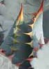
Wildflowers Observation Light
Lupine was moderate, poppies, hedgehog, thistle, hyacinth, daisies
_____________________
Navy31 Army13
 
Mar 21 2020
avatar

 Guides 3
 Routes 632
 Photos 8,235
 Triplogs 604

54 male
 Joined Apr 13 2011
 Gilbert, AZ
Ballantine to Boulder FlatPhoenix, AZ
Phoenix, AZ
Hiking avatar Mar 21 2020
ddgrunningTriplogs 604
Hiking7.90 Miles 1,680 AEG
Hiking7.90 Miles   4 Hrs   32 Mns   2.10 mph
1,680 ft AEG      46 Mns Break
 
1st trip
Linked   linked  
Partners none no partners
Route Scout Route Recorded  on Route Scout | Pop | Map | Popup | MapDEX
First time on the Ballantine Trail. Driven by the TH a thousand times, but never stopped. Figured with coronavirus concerns, this would be a road less traveled. To my surprise, though, there were 20+ cars when we arrived at the TH. Still, social distancing wasn’t a problem.

The hike exceeded expectations. About 2 mi. in, I marked a nice campsite with a view. Would make a good introductory overnight backpack location.

Later on, I tagged “Picnic Rock,” which is next door to a nice little saguaro neighborhood. Speaking of saguaros, there a a lot of impressive ones along this trail.

Given the recent rains, Camp Creek was running strong and clean. I wish the trail was located a littl me closer to the creek. As it was, you have to bushwhack down and back, but it was worth it.

Just before Boulder Flat, we tromped down to the creek and ate lunch on a nice large rock and cooled our feet in the creek.

I explored the creek a bit on the way back. Saw a snake (looked like a garter), but was too slow for the camera.

Took the north side of the Pine creek loop on the return. Water was flowing strong on that drainage as well.

The final 1/2 mile parallel to the highway detracts from nature a bit, but if you focus on the giant saguaros, rather than the traffic, it’s still nice.

Seems like there were a lot more people out in nature, after everyone’s been staying isolated the last week or so.

Now back to holing up at home ....
 Named place
 Named place [ checklist ]
[ checklist ]  Camp Creek
_____________________
  2 archives
Feb 01 2020
avatar

 Guides 2
 Routes 25
 Photos 1,890
 Triplogs 604

41 male
 Joined Sep 13 2009
 Mesa, AZ
Ballantine to Boulder FlatPhoenix, AZ
Phoenix, AZ
Hiking avatar Feb 01 2020
jochalTriplogs 604
Hiking8.50 Miles 1,600 AEG
Hiking8.50 Miles
1,600 ft AEG
 no routes
Partners none no partners
Nice to hike this with the creeks running. Quite a few people on the Pine Creek trail, but don't think many went very far on Ballantine. Also went over to check out the cabin and corral. The corral is in good shape. The cabin is missing half the roof, but the pieces are still around.
_____________________
 
Jan 18 2020
avatar

 Routes 268
 Photos 2,969
 Triplogs 541

66 male
 Joined Aug 16 2009
 Mesa,AZ
Rock Walls off Pine Creek, AZ 
Rock Walls off Pine Creek, AZ
 
Hiking avatar Jan 18 2020
hikerdwTriplogs 541
Hiking14.48 Miles 3,369 AEG
Hiking14.48 Miles   6 Hrs   31 Mns   2.48 mph
3,369 ft AEG      40 Mns Break
 
1st trip
Partners none no partners
While scanning the terrain planning for an upcoming hike in the Boulder Flat area I noticed what looked like rock walls with four square corners so figured it was worth checking out. In further planning I noticed what looked like a motor bike trail that could be used to get us really close to the target point. Motor bike trails are like a jeckle and hyde, on the plus side it gives you a route to follow and sometimes help you get through some thick vegetation, but on the minus side sometimes hiking deep ruts just isn't that easy.

The hike in to the turnoff to the cabin was smooth sailing, the trail is in great condition and the creek has a nice flow of water. After the turnoff to the cabin is when we started seeing the deep ruts in the trail caused by motor bike activity. Glanced in the cabin but didn't stop. Got to the junction where we needed to start our climb up but had to first check out the flow from Pine Creek as we could hear it pretty good. Started the climb up, pushing through lots of sticky plants, and digging in the heals where the granite was loose. Overshot the turnoff point slightly so backtracked a bit until we found a good point to leave the trail and make our way to the target point. I'm not that knowledgeable when it comes to rock walls so not sure if these are ruins or a corral type structure. We did notice some inner walls which I would think would be odd in a corral. We also noticed two other walls in the hike in/out.

Overall a great hike that covered some new terrain for us. Lots of running water. On the return we stopped at the picnic table at the cabin to enjoy a 5 short break, much appreciated. Passed one lone hiker on the way in, and then started seeing others on the return once we were within 3 miles of the trailhead.

water 1 out of 5water 2 out of 5water 3 out of 5water less than max Pine Creek Medium flow Medium flow
_____________________
Expect to self rescue
 
Jan 17 2020
avatar

 Guides 1
 Routes 5
 Photos 656
 Triplogs 512

47 male
 Joined Jul 20 2007
 Gilbert, AZ
Ballantine to Boulder FlatPhoenix, AZ
Phoenix, AZ
Hiking avatar Jan 17 2020
jtaylorTriplogs 512
Hiking6.50 Miles 1,380 AEG
Hiking6.50 Miles
1,380 ft AEG
 no routesno photosets
1st trip
Linked   none no linked trail guides
Partners none no partners
Great morning hike with Jeff. Had never done this one before. Beautiful gem after getting away from the highway noise. Nice sunny day and great to catch up with Jeff after a few years!

Water was flowing still. Saw some lupine sprouting. Can’t wait for that...
_____________________
“...wilderness is not a luxury but a necessity of the human spirit, and as vital to our lives as water and good bread.”
-Edward Abbey, Desert Solitaire
 
Jun 22 2019
avatar

 Photos 7
 Triplogs 9

44 male
 Joined May 09 2011
 Gilbert, AZ
Ballantine to Boulder FlatPhoenix, AZ
Phoenix, AZ
Hiking avatar Jun 22 2019
DukedanteTriplogs 9
Hiking1.64 Miles 477 AEG
Hiking1.64 Miles   1 Hour   10 Mns   1.59 mph
477 ft AEG      8 Mns Break
 
no photosets
1st trip
Linked   none no linked trail guides
Partners none no partners
Route Scout Route Recorded  on Route Scout | Pop | Map | Popup | MapDEX
Super hot. Lots of highway noise. Probably would be worth it in winter when you can get far from the highway quickly. Not so much in the summer.
_____________________
 
May 26 2019
avatar

 Routes 26
 Triplogs 282

39 male
 Joined Apr 14 2019
 Phoenix, AZ
Ballantine to Boulder FlatPhoenix, AZ
Phoenix, AZ
Hiking avatar May 26 2019
richvoskoTriplogs 282
Hiking8.80 Miles 1,654 AEG
Hiking8.80 Miles   4 Hrs   41 Mns   1.94 mph
1,654 ft AEG      9 Mns Break
 
no photosets
1st trip
Linked   none no linked trail guides
Partners none no partners
 
average hiking speed 2.11 mph
1, 2, 3, 4, 5 ... 8  Next

WARNING! Hiking and outdoor related sports can be dangerous. Be responsible and prepare for the trip. Study the area you are entering and plan accordingly. Dress for the current and unexpected weather changes. Take plenty of water. Never go alone. Make an itinerary with your plan(s), route(s), destination(s) and expected return time. Give your itinerary to trusted family and/or friends.

helpcommentissue

end of page marker