username
X
password
register
for free!
help
ArticlesGuidesRoutes
 
Photosets
 
 Comments
triplogs   photosets   labels comments more
Cibecue Creek - 26 members in 44 triplogs have rated this an average 4.5 ( 1 to 5 best )
1, 2, 3  Next
44 triplogs
login for filter options
Jul 01 2023
avatar

 Guides 18
 Routes 298
 Photos 1,808
 Triplogs 277

female
 Joined Mar 11 2002
 Gilbert, AZ
Cibecue CreekGlobe, AZ
Globe, AZ
Canyoneering avatar Jul 01 2023
VashtiTriplogs 277
Canyoneering4.63 Miles 391 AEG
Canyoneering4.63 Miles   3 Hrs   47 Mns   1.61 mph
391 ft AEG      54 Mns Break
 
1st trip
Linked   none no linked trail guides
Partners none no partners
Route Scout Route Recorded  on Route Scout | Pop | Map | Popup | MapDEX
First time to cibecue falls for me. It's something I've wanted to do for quite some time, so I'm happy to have been able to go. This is not a super great time to go, as it was rather hot. We got there as early as possible, but since permits are not available online, we had to go to go to the Sinclair gas station in Carrizo on the reservation to get permits ($45 per person). They open at 7a on Saturday. It took some time to get our permits, and we arrived at the trailhead and started hiking at 830a.

The tribal ranger checked our permits closely at the very start of the dirt road to the trailhead. We also passed another ranger coming the other direction on our way in. He mentioned that people were getting stuck in the creek when they crossed with the cars to get to the parking lot, and that we should use 4wd if we wanted to cross. We decided to park prior to the creek crossing. You are not allowed to park right before the crossing, but you can park a little ways before. The no parking signs are posted very clearly, and the second ranger mentioned it, as well. That being said, there were cars parked right next to the no parking signs when we were on our way out. After crossing the creek on foot, I think my grand Cherokee would have had no problem crossing in 4wd. Prior to the crossing, we saw 2 sedans parked, as well. I personally would not take a passenger car on that road. There were mainly trucks, jeeps, and a few awd suvs parked when we left.

The road itself is bumpy but not terrible. It's narrow in a lot of places which makes it not fun when two cars meet going in opposite directions on the steep sections. Quite a bit of the road is high above the canyon floor with a big drop off.

Hiking itself was beautiful, as expected. :) The usual water hike, back and forth across the creek many times. Spectacular scenery. There were about 3 deep pools including the one at the foot of the falls, but you did not have to go through them. Swimming is not allowed (but is maybe allowed for tribal members?), though it is possible to keep cool coming in and out of the water while crossing. The trail guide mentioned having to go through one deep pool, but the water level is not super high right now. We were able to follow well-worn use paths on either side of the creek all the way to the falls without having to be in the creek for extended periods.

We were the first ones to the falls in the morning, much to our delight!! It was simply magical with the roaring of the falls. So much water!! The hanging garden off to the left is beautiful. Plus, some one was busy making several cairns in the shallow area of the creek right before the deep pool at the base of the falls. They were really neat to see when you turn the corner and get your first view of the falls.

We had the place to ourselves for about an hour. Then... The influx of people begun. 11 people, 2 families came, so we decided it was time to start back as it was getting hot anyway. Including the 11 people we saw at the falls, we counted 50 people on the trail in as we walked out. Yikes!! I am so glad we were able to see the falls in solitude.

The heat made for a not super great hike out, but that is what you get when you go in a non optimal season. I am still glad we went. Between the excessive crowds and the steep price of permits, I am not sure we will be back any time soon. Maybe on a Wednesday in season! 😂

Beautiful hike! 😁😁😁
wildflower observationwildflower observationwildflower observationwildflower observationwildflower observation
Wildflowers Observation Isolated
Unexpectedly saw a few wildflowers here and there. Given the heat, I didn't expect to see any!

water 1 out of 5water 2 out of 5water 3 out of 5water less than max Cibecue Creek Medium flow Medium flow
_____________________
:D
  3 archives
May 20 2023
avatar

 Routes 31
 Photos 4,724
 Triplogs 187

50 male
 Joined Mar 14 2016
 Gold Canyon, AZ
Cibecue CreekGlobe, AZ
Globe, AZ
Canyoneering avatar May 20 2023
00blackoutTriplogs 187
Canyoneering3.90 Miles 240 AEG
Canyoneering3.90 Miles
240 ft AEG
 no routes
1st trip
Linked   none no linked trail guides
Partners none no partners
Up before the sunrise to make the long trek up to the White Mountain Apache res and over the Cibecue Creek Trailhead to hike up to the Falls. This hike has been on my list for awhile now and finally got the opportunity to do it. You can't buy the permits online right now so we had to drive about 20 minutes past the turnoff to get them. It wasn't too bad just a bit out of the way. Got to the TH a little after 9, with about 5 other cars already there and off we went. Cibecue Creek while flowing pretty good looked like chocolate milk. The rains from the past couple of days, must have really stirred up the mud because you could not see a thing in it, which made it interesting for the dozen or so creek crossings. Made it to the falls at a decent time and spent some time there relaxing and enjoying the scenery. The hike back out was uneventful but hot and humid from all the trees and water. Once I got back to the truck a tribal LEO asked me for my permit which was to be expected as there are people out there that try to hike it without buying one. Stopped for a late lunch at Guayo's on the way home, which is always good! The whole Cibecue area is beautiful and the chocolate milk water made it interesting, would definitely like to see it when the water is clear.
 Named place
 Named place [ checklist ]
[ checklist ]  Cibecue Creek

water 1 out of 5water 2 out of 5water 3 out of 5water 4 out of 5 Cibecue Creek Heavy flow Heavy flow
Chocy Milk
_____________________
Hiking is just walking where it’s okay to pee. :y:
 
Jun 05 2022
avatar

 Guides 2
 Routes 127
 Photos 1,478
 Triplogs 129

male
 Joined May 07 2019
 Tempe, AZ
Cibecue Falls, AZ 
Cibecue Falls, AZ
 
Hiking avatar Jun 05 2022
mikemcgTriplogs 129
Hiking3.89 Miles 309 AEG
Hiking3.89 Miles   2 Hrs   55 Mns   2.16 mph
309 ft AEG   1 Hour   7 Mns Break
 
1st trip
Linked   linked  
Partners none no partners
Route Scout Route Recorded  on Route Scout | Pop | Map | Popup | MapDEX
It was a beautiful day and the sun was intense. The falls were flowing strongly. The water was clear and relatively warm. There were over 30 people when we arrived at the falls, but many cleared out shortly afterward, so we enjoyed some quality time there.

The Apache website was not processing payments, so visitors were required to go to the gas station in Carrizo (25 miles east of the trailhead, so 50 miles of additional driving) to buy the permits. The permit fees recently increased to $45 per person. Game and Fish officers were stopping every vehicle to check for permits, and they were denying entry to those who didn't have them.

When we returned to the car, I was carrying a full bag of trash that we had picked up along the trail. People are disgusting.

water 1 out of 5water 2 out of 5water 3 out of 5water less than max Cibecue Creek Medium flow Medium flow
 
Apr 09 2022
avatar

 Photos 5
 Triplogs 1,041

36 female
 Joined Oct 04 2012
 Phoenix, AZ
Cibecue CreekGlobe, AZ
Globe, AZ
Canyoneering avatar Apr 09 2022
WaitingForRainTriplogs 1,041
Canyoneering4.00 Miles 240 AEG
Canyoneering4.00 Miles
240 ft AEG
 no routesno photosets
1st trip
Linked   none no linked trail guides
Partners none no partners
_____________________
 
Nov 11 2016
avatar

 Guides 9
 Routes 118
 Photos 1,079
 Triplogs 118

35 male
 Joined Mar 06 2016
 Salt River Valle
Bonita and Cibecue Creeks, AZ 
Bonita and Cibecue Creeks, AZ
 
Backpack avatar Nov 11 2016
arizona_waterTriplogs 118
Backpack9.70 Miles
Backpack9.70 Miles2 Days         
 
1st trip
Linked   linked  
Partners none no partners
Veterans Day weekend provided off, so we headed out to the Gila Box for what was supposed to be a chill backpacking trip. The posted route is of our route north (one-way).

Friday:
We left the Valley at 7a.m. The drive went by fast, but that last 5 miles on the road to Bonita Creek is slow and uncomfortable, to say the least. We arrived at 11a.m. and the creek was still super high from a recent flood event, which I verified with the stream gage data. Unfortunately, this made trekking on the banks and in the creek very difficult. Walking in the creek was very muddy and the water was deep. Walking on the banks was straight bushwhacking, every step of the way. Even with long sleeves and pants, my arms and legs were bleeding in the first few hundred meters. This was definitely not the greatest backpacking trip I've been on. We didn't make it to our planned destination (junction with Midnight Canyon) on Friday night and pitched the tents on a grassy-ish bank near the creek.

Saturday:
With the realization that we travelled three miles yesterday in five hours, we decided to just return back to the vehicle. I was a little disappointed we didn't get to see midnight canyon, but my feet were soaked and cold by this point, and I didn't care where we were going as long as I could take my boots off soon. We made better time on the return, arriving back at the vehicle in three hours. It was only 12:30pm, as we began the rough drive out, so we decided to to salvage the day. Originally, the plan was to drive over to Gillard Hot Springs and spend the night there on the banks of the Gila. But we chose to continue through Clifton and Morenci along highway 191. Wow, what an incredible drive! The San Francisco River in Clifton is one of epic historical and ecological value. Highway 191 then follows the ridgeline all the way through Hannagan's Meadow, and then on to Alpine. And the sunset seemed to follow us the whole way. We spent the night at a friend's cabin just outside of Pinetop.

Sunday:
After mandatory breakfast burritos at Eddie's Country Store, we drove down highway 60 to the Salt River and hiked to Cibecue Falls. The Creek was flowing higher than base flow. I saw the USGS/SRP stream gage and told the group about the comprehensive hydrologic models that SRP uses. After the hike, I walked down to the confluence with the Salt. This River is crucial to Arizona. This view and this hike certainly redeemed all my mixed feelings about the high-water Bonita Creek.

water 1 out of 5water 2 out of 5water 3 out of 5water 4 out of 5 Bonita Creek Heavy flow Heavy flow
Riparian area was flooded, above bankfull


dry Sycamore Canyon Dry Dry
_____________________
- there's nothing like finding Water in the Desert -
  2 archives
Oct 29 2016
avatar

 Photos 10
 Triplogs 2

38 male
 Joined Feb 09 2016
 Chandler, AZ
Cibecue CreekGlobe, AZ
Globe, AZ
Canyoneering avatar Oct 29 2016
urbanformTriplogs 2
Canyoneering3.10 Miles 240 AEG
Canyoneering3.10 Miles   3 Hrs   30 Mns   0.89 mph
240 ft AEG
Canyon Hiking - Non-technical; no rope; easy scrambling; occasional hand use
B - Up to light current; wading/swimming; possible wet/dry suit
II - Normally requires a half day
 no routes
1st trip
Linked   none no linked trail guides
Partners none no partners
This was a beautiful experience. I highly recommended it! I want to reiterate the important details about this hike:

#1) The dirt road to drive in does have some areas of sheer cliffs on the side and an SUV is recommended. You could probably do it in a car if you have higher clearance than average. You do have to cross a creek in your vehicle unless you take one of 2-3 available parking spots that appear immediately before the creek crossing to your left. You can park in one of those spots and start your hike by crossing the creek on foot, since you have to do that about 10-15 times during the hike anyway. But there is more parking if you simply drive across the creek, which is the normal parking area. It seemed like it could fit about 20 vehicles.

#2) The permits are for Noon to Noon. 24 hour pass. $15 per person (adult). We actually waited until Noon to enter the reservation just in case. I'm not sure how important that is.

#3) There is some trash along the hike. We didn't bring a garbage bag. I usually try to bring a trash bag to haul out trash that I discover. If you have the desire to, please bring a bag and help us all clean up the place a bit. I brought back some water bottles that we found and a few cans in my pack.

#4) Don't go after a rain, I read reviews online that said the water is much more brown/mucky after a rain. You also don't want the water to be too high. We were up to our knees a few times and hiked in October.

Enjoy!
foliage observationfoliage observationfoliage observationfoliage observationfoliage observation
Autumn Foliage Observation Light
_____________________
 
Jul 23 2016
avatar

 Routes 386
 Photos 49
 Triplogs 792

43 female
 Joined Jun 23 2015
 Phoenix, AZ
Cibecue CreekGlobe, AZ
Globe, AZ
Canyoneering avatar Jul 23 2016
emilystardustTriplogs 792
Canyoneering3.10 Miles 240 AEG
Canyoneering3.10 Miles
240 ft AEG
 no routesno photosets
Linked   none no linked trail guides
Partners none no partners
_____________________
 
May 01 2016
avatar

 Guides 94
 Routes 842
 Photos 22,068
 Triplogs 1,994

52 male
 Joined Sep 18 2002
 Tempe, AZ
Cibecue CreekGlobe, AZ
Globe, AZ
Canyoneering avatar May 01 2016
chumleyTriplogs 1,994
Canyoneering5.00 Miles 324 AEG
Canyoneering5.00 Miles   6 Hrs   43 Mns   2.17 mph
324 ft AEG   4 Hrs   25 Mns Break
Canyon Hiking - Non-technical; no rope; easy scrambling; occasional hand use
B - Up to light current; wading/swimming; possible wet/dry suit
I - Short 1-2 hours
 no routes
1st trip
Linked   none no linked trail guides
Partners partners
Jonnybackpack
I put on my Dr. Phil hat and headed out to provide some hop therapy. Sometimes it's nice just to listen to the wilderness. :)
wildflower observationwildflower observationwildflower observationwildflower observationwildflower observation
Wildflowers Observation Isolated

water 1 out of 5water 2 out of 5water 3 out of 5water less than max Cibecue Creek Medium flow Medium flow
16cfs at the gauging station
_____________________
I'm not sure what my spirit animal is, but I'm confident it has rabies.
 
Mar 13 2016
avatar

 Photos 398
 Triplogs 49

male
 Joined Jul 20 2002
 Gilbert, AZ
Cibecue CreekGlobe, AZ
Globe, AZ
Canyoneering avatar Mar 13 2016
Digital_SherpaTriplogs 49
Canyoneering3.10 Miles 240 AEG
Canyoneering3.10 Miles
240 ft AEG
 no routes
1st trip
Linked   none no linked trail guides
Partners none no partners
I know most do this hike later when the temps heat up but hiking in cold water doesn't bother me. In fact, the water felt warmer than I was expecting. Great flow down the creek right now with lots of picturesque waterfalls to distract your attention along the way to the big payoff. A few folks showed up at the waterfall while I was waiting for the light to get good but other than that I had the canyon to myself. This is a great hike, even with the tribal permit requirement.
_____________________
http://www.ronadcockphotography.com
 
Mar 03 2016
avatar

 Routes 16
 Photos 628
 Triplogs 45

72 male
 Joined Apr 03 2011
 Mesa, Az
Cibecue CreekGlobe, AZ
Globe, AZ
Hiking avatar Mar 03 2016
gmaclachlanTriplogs 45
Hiking5.00 Miles 240 AEG
Hiking5.00 Miles
240 ft AEG
 no routes
1st trip
Linked   none no linked trail guides
Partners none no partners
With temps in the mid 70's in the White Mountains we thought it may be our only chance to see Cibecue Creek and the falls. (have to head back north soon) Creek was only flowing 30 cfs and was about the same temperature as a Canadian Lake in the summer. Called the Band office and found out a Band Member would be at the bridge dealing with the "rafters" so we could get day hiking passes from her. Road has had some repair work done and was in good condition. Lots of "rafters" on the Salt and few tourists at the trail head, but we had the creek all to ourselves. Lost count of how many times we crossed the stream, most crossings were ankle deep with a couple above the knees. Some boulder hopping and muddy spots make the hike just above "easy" but a great day trip.
 Named place
 Named place [ checklist ]
[ checklist ]  Cibecue Creek
wildflower observationwildflower observationwildflower observationwildflower observationwildflower observation
Wildflowers Observation Light
_____________________
 
Feb 07 2016
avatar

 Photos 14
 Triplogs 1

35 male
 Joined Nov 21 2013
 Tempe, AZ
Salt River Canyon - US60 CrossingGlobe, AZ
Globe, AZ
Hiking avatar Feb 07 2016
pyro4lifTriplogs 1
Hiking
Hiking
 no routes
1st trip
Linked   linked  
Partners none no partners
Had an adventure Sunday feb 7th, exploring canyons and chasing waterfalls. I found a few spots on the map, couple of seasonal waterfalls and then some known perennial waterfalls, that I wanted to visit. Altogether around 750 feet of waterfalls.

fist stop 2 am at a frozen 250ft seasonal waterfall because who doesn't like hiking around icy sheer cliff faces in complete darkness?
It was Saturday night clear skies and almost the new moon.
I began hiking my hike soon Hearing the sound of a running creek I began to get very excited. Hopping along the rocks in the icy creek bed my anticipation built, and soon enough right in front of me the creek disappears into complete blackness. I carefully walk to the icy edge of the waterfall knowing one mis-step my life would be over. Shining my headlamp down I can see absolutely nothing because it only shines 120 feet not even half way to the bottom of the waterfall. Looking across I can see a faint cliff face that looked like it would be a good vantage point to view the fall.
I thought it would be an easy hike over, but it turns out hiking in the pitch black on the edge of cliffs is a bit of a challenge as it helps to be able to see where you are going. My destination ended up being a narrow rock spire that jetted out from the canyon sides. I had just enough room to sit on the edge and set up my tripod and take a few pictures. Not seeing much I could hear the sound of the falls, the wind howling, and large chunks of ice breaking off the falls and crashing into the waters below.
Definitely not the safest thing but it was quite the rush and a good start to the next 24 hours of adventure!

I love the night but nothing beats a bright warm sun! After my night photography adventures I drove to a scenic vista pull off on the side of the HW so I would have a great view for the sunrise. Getting to sleep around 4, I awoke in a daze around 5:30 to loud country music! Why person did you decided to pull up next to me and blast music for an hour? Couldn’t you have parked anywhere else? or at least like better music? I have no idea but I was too unconscious to do anything about it at the time. I got up around 7:30 to soak in the sunrise, then start my drive down a long dirt road to another seasonal waterfall. Stopping next to the river along the way to cook some breakfast and sing songs with my Father. Ended up having such a sweet time leaving me in tears feeling extremely loved, cared for, and accepted. Moments like these are what I live for. Peace that I can’t even understand! The eggs were delicious too.

Next stop another seasonal waterfall
Out of all the falls I visited that day this was my favorite. The falls cascade down 450ft of powerful and almost majestic looking cliff faces, I had so much fun climbing up this waterfall, I took a shower in the fall, bathed in its pools, laid out on the rocks soaking in the sun and took a nap listening to the relaxing sounds of the falls.
After my nap I hiked down and started off the the next waterfall I wanted to visit that day.

Next stop Lower Falls of Cibecue Creek, many of you might recognize this spot because it's a popular swimming hole in the summer months.
Even though it is winter time and the water was very cold, the flow was very strong due to snow melt so I really wanted to see the falls raging! I got to the trail-head later in the afternoon giving me just enough time to hike in and out in time to get to a vista to watch the sun set. That’s if I started then but I decided to rest first as I was feeling my last two adrenaline filled hikes on top of little sleep. I hit the trail a little after 5 with my watermelon in hand. The canyon views are very striking; I really love this part of AZ. I knew with the creek so high I would not be able to stay out of the water. On the first crossing the water didn’t feel too cold but with each crossing it seemed to get colder. I got to the falls just as the sun was setting; it was quite a powerful scene. The falls demand respect, its roar amplified by the narrow slot canyon walls that the water carved. The flow was so strong the fall was split into 3 separate falls, creating a 2 ft wave at the base and a good amount of foam on the water. Just me and the bats there to soak it all in.
The hike back proved to be a challenge in the dark, not being able to see the bottom of the creek and having numb feet from the cold. What’s a good adventure without challenge? I’d definitely do it again!
On my way out I had one more waterfall to visit. Apache Falls are very easy to get to, not too far off the HW, but is one of the few waterfalls in AZ that is in a river not a creek. It is an impressive fall because of the size and the amount of water flowing over them (especially after snowmelt).

Snowmelt swells the river to a roar as she winds through the towering majestic canyon walls, a sight only the stars can fully take in.
_____________________
 
Jun 21 2015
avatar

 Routes 386
 Photos 49
 Triplogs 792

43 female
 Joined Jun 23 2015
 Phoenix, AZ
Cibecue CreekGlobe, AZ
Globe, AZ
Canyoneering avatar Jun 21 2015
emilystardustTriplogs 792
Canyoneering3.10 Miles 240 AEG
Canyoneering3.10 Miles
240 ft AEG
 no routesno photosets
Linked   none no linked trail guides
Partners none no partners
Just wanted to update others on permits, since we ran into a couple issues. We went to Sportman's Warehouse in Mesa to purchase permits, as we decided somewhat last minute that this was going to be the destination. They informed us that their machine had broken back in September, and it had been picked up to get fixed and never returned. The lady told us we could get permits closer to the destination, which I assumed meant the Globe area. Quickly Googled Black/Salt River Special Use Permits to find an alternate location and several convenience stores/gas stations were listed. We picked up what we thought were the correct permits (they were called Black/Salt River Special Use Permits) from Express Stop in Globe and ended up paying $25 each. However, I realized when we returned home that they were for the adjacent San Carlos Reservation. I am guessing we had the wrong permits, so I am glad we didn't get stopped anywhere. I would definitely recommend just purchasing online from the White Mountain Apache website.
_____________________
 
Aug 23 2014
avatar

 Routes 1
 Photos 14
 Triplogs 8

54 female
 Joined Jan 08 2014
 Phoenix, AZ
Cibecue CreekGlobe, AZ
Globe, AZ
Hiking avatar Aug 23 2014
alittlediamondTriplogs 8
Hiking4.00 Miles 240 AEG
Hiking4.00 Miles
240 ft AEG
 no routes
1st trip
Linked   none no linked trail guides
Partners none no partners
The drive in was just fine. We parked before the creek crossing, as the creek was pretty high from the big storms we've gotten the past 2 weeks.

The storms also caused the creek to be chocolate brown. The area was absolutely gorgeous but I plan to come back again next summer and hope for clearer water. The water was so dark that you couldn't see even an inch deep. This made it impossible to see rocks just below the surface and left us unable to judge the water depth anywhere. This was a fun challenge but it took us a lot longer to reach the waterfall because of it.

The water was usually about ankle to mid calf deep, except towards the end where we got some places that were over waist deep when trying to avoid the very thick and deep mud on the sides of the canyons. Water temp was chilly but definitely not cold. Air temp was in the low-mid 80's so it was perfect.

It was a gorgeous day, no signs of the monsoons we've been having recently and we had a great time.

water 1 out of 5water 2 out of 5water 3 out of 5water less than max Cibecue Creek Medium flow Medium flow
_____________________
 
May 25 2014
avatar

 Guides 2
 Routes 58
 Photos 1,254
 Triplogs 221

52 male
 Joined Dec 26 2009
 Phoenix, Az
Cibecue CreekGlobe, AZ
Globe, AZ
Canyoneering avatar May 25 2014
WilliamnWendiTriplogs 221
Canyoneering3.10 Miles 240 AEG
Canyoneering3.10 Miles   4 Hrs      0.89 mph
240 ft AEG      30 Mns Break
 no routesno photosets
1st trip
Linked   none no linked trail guides
Partners none no partners
After our GC hike, we're trying to fall in to the same trap as after Havasu Falls. It is hard to match the level of excitement of those hikes. Cibecue seemed to have a little of their flare, but short enough to not require their preparation requirements.
Before we got to the hike we had a few noteworthy experiences. The first were the problems getting permits from WMAoutdoors.org's website, I suspect the site was just overloaded with the Memorial day crunch, because first thing the morning of our hike I checked back and was able to effortlessly acquire the two permits needed. First however we, in lieu of our first failed attempt with WMA website, the night before our hike, we went to the 27th ave Sportsman's Warehouse, and were told that this store no longer carried the permits, only their Mesa Store did. Long story short, if we hadn't been able to purchase permits online, our hike wouldn't have started at noon but probably 1:30. Either way we were glad to finally tackle this trail.
I am not sure why their permitting system forces you to start your adventures at noon, the beginning of the hottest part of the day, but luckily we had fairly mild day with plenty of over cast and cool 82 degree weather. The permit is good till noon following day and includes camping but in all the confusion of getting the permit we gave up on trying to plan camping trip.
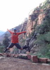
The drive on the last 4 miles of dirt road was little stressful in a Altima but in the end proved doable. But we got started right a noon. We saw plenty of people hiking back out. Some had packs and had clearly camped in the canyon. The water was very clear and just cold enough enough to be refreshing but not warm enough to want to swim in. Very beautiful hike, I might compare it to Aravaipa, one of the coves reminded Wendi of the cave on Fish Creek, and parts reminded her of Oak Creek. Some have compared it to Havasu, and it had a little of those blue-green waters.
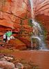
We could hear the rush of the falls before we ever saw them, and the anticipation did not lead to disappointment. The shadows of the over hangs grew in and out as the clouds danced with the sun above casting their own shadows on the wall to wall waters, broken only by small pebbled islands, that pooled in the final, allowable, fifty feet of the Cibecue Canyon.
We were one of two couples who had reached the canyon at the same time and the 4 of us alone shared falls together. Wendi and I sat on side to eat our lunch of Tuna and jerky, which proved too much for the other couples K9 companion. She left her humans, and ignored their calls, to saunter over and get some pets from us, but no treats. Finally she relented to the calls of her owners but every once in awhile tried to make an attempt to cross back over but sadly we only got the one visit. As cat owners we can only live our K9 dreams vicariously through others.
We didn't see to much fauna. Possibly, a partial bear track, a few schools of minnows, one pesky pill sized breed of bug that looked like a moth. It was grey blue and kept attaching itself to my leg, and I am not usually bothered by stowaways, they can usually ride for free as long as they like, but this was either biting or really holding tight. I kept brushing him off, but for the first 1/4 mile of the hike he would just reappear seconds later often in exactly the same spot. We were able to stay, with the exception of the first crossing from the alternate parking area, dry until we reached Gauging Station, then we had to get wet, after that my little buggy friend seemed to go away. Besides that not much else until I spotted this crazy creature in the water. It reminded me of that ear-thingy in the Wrath of Kahn. I stepped towards it to get a picture, it was clinging to the calcite covered gold rock in the current of the water, and it seemed to lung at my feet before retreating back an inch. I now know that it was Hellgrammite, and the larva of the Dobsonfly which is the same 2" long demon but with wings. I saw pictures of people with these things in their hand! Not me, no thank you.
On the drive home there was a head-on collision blocking Hghwy 77/60, both directions. Sadly, it was a car vs. semi, there was a fatality. For us, it meant a 1/2 hour, sitting there with the ignition off. I guess we were situated close enough the crash in a stretch of highway which they needed to have cleared. Besides the horse-trailer behind us the rest and thirty cars ahead, the rest of the traffic were waiting another 4 hours, both directions. The truck driver looked safe and in good health, if a little distressed.
_____________________
The Tree of Understanding, dazzling, straight, and simple, sprouts by the spring called Now I Get It. - Wislawa Szymborska, "Utopia"
 
May 21 2014
avatar

 Routes 1
 Photos 140
 Triplogs 20

male
 Joined May 01 2014
 show low
Cibecue CreekGlobe, AZ
Globe, AZ
Hiking avatar May 21 2014
azfamilyhikeTriplogs 20
Hiking4.10 Miles 240 AEG
Hiking4.10 Miles
240 ft AEG
 no routes
1st trip
Linked   none no linked trail guides
Partners none no partners
The family and I wanted to get out of town for the day so we took up this hike. We parked before the creek and walked across to the trail head. The first thing that caught our eye was the huge canyon walls, for some reason I was enamored by them.

The hiking was fun we took our time and crossed the creek back and forth quite a few times. I climbed the gaging station to play around, but the cable cart was locked up :( Our son was having a blast wading in out out of the pools in the creek.

Surprisingly we did not see much wildlife except for one loan squirrel and a bright red cardinal. The creek is such a beautiful place we enjoyed every turn. There is a cool little cave that the water must have carved out as some is very cool, the water is clear with a greenish blue tint to it. I could hear the water fall just before we made it around the last turn. The waterfall was was awesome. I took my day pack off and we relaxed here for quite some time, had some fun and enjoyed the water.

The hike back was uneventful but I did a cool refection picture in one of the pools. Overall we always have fun when the family and I are hiking together :)
 Culture
 Culture [ checklist ]
[ checklist ]  HAZ - Selfie  Humor
 Named place
 Named place [ checklist ]
[ checklist ]  Cibecue Creek
wildflower observationwildflower observationwildflower observationwildflower observationwildflower observation
Wildflowers Observation Moderate
_____________________
 
May 08 2014
avatar

 Guides 20
 Routes 12
 Photos 2,343
 Triplogs 298

51 male
 Joined Mar 31 2008
 Gilbert, AZ
Cibecue CreekGlobe, AZ
Globe, AZ
Canyoneering avatar May 08 2014
ssk44Triplogs 298
Canyoneering3.00 Miles
Canyon Hiking - Non-technical; no rope; easy scrambling; occasional hand use
B - Up to light current; wading/swimming; possible wet/dry suit
I - Short 1-2 hours
 no routes
1st trip
Linked   none no linked trail guides
Partners none no partners
I haven't posted for awhile so I thought I would check in with a special recent trip. I finally visited Cibecue Creek. Of all the places I've been throughout this state, I'm frankly amazed it took me this long to come hear. The upper grotto waterfall is very unique and special. Although the creek along the way up had it's moments, they all fall short of the last 1/4 mile. That's where the money is. The entire experience is well worth the $15 price of admission. I went during the week on a rather cool day so I had the entire place to myself. That's just how I wanted it. While driving out at the end of the day I was blessed with a scrumptious view of the Salt River at Mule Hoof Bend that was simply perfect. Really fun trip.


Eric


Warning: This canyon is particularly dangerous during summer monsoon months. The upper watershed for Cibecue Creek is very large. Flash floods from the upper watershed can be violent and happen with little notice in the lower canyon. Sun shining at the TH and along the lower hike route does not guarantee safety. Anyone within a 1/4 mile of the upper grotto waterfall (official hike end) would not likely survive a large flash flood. Take great care in analyzing local weather data prior to planning a visit during monsoon season. *See below link for current and historical USGS stream flow data within Cibecue Creek.

http://waterdata.usgs.gov/az/nwis/uv/?s ... 0065,00060


__
 Named place
 Named place [ checklist ]
[ checklist ]  Mule Hoof Bend
_____________________
MATTHEW 11:28-30 / PSALM 84:1-2
 
Sep 21 2013
avatar

 Triplogs 78

female
 Joined Sep 25 2012
 Phoenix, AZ
Cibecue CreekGlobe, AZ
Globe, AZ
Canyoneering avatar Sep 21 2013
meg_thomas00Triplogs 78
Canyoneering3.10 Miles 240 AEG
Canyoneering3.10 Miles
240 ft AEG
 no routesno photosets
1st trip
Linked   none no linked trail guides
Partners none no partners
_____________________
 
Jun 15 2013
avatar

 Guides 41
 Routes 1,627
 Photos 14,983
 Triplogs 2,762

69 male
 Joined Jan 20 2009
 Far NE Phoenix,
Cibecue CreekGlobe, AZ
Globe, AZ
Hiking avatar Jun 15 2013
The_EagleTriplogs 2,762
Hiking3.24 Miles 529 AEG
Hiking3.24 Miles   2 Hrs   11 Mns   1.58 mph
529 ft AEG      8 Mns Break14 LBS Pack
 
1st trip
Linked   none no linked trail guides
Partners partners
joebartels
We were sort of in the area and I needed to check this one out.

The 4 mile long drive off of Rt 60 was accessible for any vehicle. But......
** Note ** Unless you have 4 x 4, Do NOT try to cross the creek to get to the TH. Park on the east side of the creek and walk across. You are going to get wet anyway. The creek is not deep, is covered in small rocks and looks easy to cross, but you WILL sink and get stuck. I read the Tibber/Snakemarks triplog were they got stuck and had to get towed and there was another non-4 x 4 Toyota that was stuck trying to get back across while we were there. Luckily Joe talked me into parking before crossing.

Now, the hike... We started about 2:30p and there were 7 or 8 vehicles at the TH, so we expected a crowd. Luckily for us, we passed everyone of them leaving, as we were going to the falls.

There are use trails for the majority of this hike on both sides, but why not just walk through the water.

The whole hike was real picturesque, but turning that corner and seeing the falls and that Blue water...BAM!. Quite the site... pictures do not do it justice. We cooled off for a bit and the made our way back to collect the truck.

A long drive out there, but something that needs to be seen.

Video == :next: https://www.youtube.com/watch?v=wuygtsfYvtE
 Fauna
 Fauna [ checklist ]
[ checklist ]  Teva
 Named place
 Named place [ checklist ]
[ checklist ]  Cibecue Creek
wildflower observationwildflower observationwildflower observationwildflower observationwildflower observation
Wildflowers Observation Isolated

water 1 out of 5water 2 out of 5water 3 out of 5water less than max Cibecue Creek Medium flow Medium flow
Lots-o-water
_____________________
There is a very fine line between "hobby" and "mental illness."
Dave Barry 🦅
 
Jun 15 2013
avatar

 Guides 264
 Routes 2,798
 Photos 14,514
 Triplogs 5,895

55 male
 Joined Nov 20 1996
 
Cibecue CreekGlobe, AZ
Globe, AZ
Hiking avatar Jun 15 2013
joebartelsTriplogs 5,895
Hiking3.10 Miles 240 AEG
Hiking3.10 Miles   2 Hrs   5 Mns   1.69 mph
240 ft AEG      15 Mns Break10 LBS Pack
 
1st trip
Linked   none no linked trail guides
Partners partners
The_Eagle
about 30 people in the canyon, use-trails make it a breeze
_____________________
- joe
 
Apr 13 2013
avatar

 Photos 281
 Triplogs 222

45 male
 Joined Aug 03 2008
 Chandler, AZ
Cibecue CreekGlobe, AZ
Globe, AZ
Canyoneering avatar Apr 13 2013
knmurphyTriplogs 222
Canyoneering 240 AEG
Canyoneering
240 ft AEG
Intermediate Canyoneering - Difficult or dangerous; Tech Climb; rope reqd; descent anchor; exit technical;
B - Up to light current; wading/swimming; possible wet/dry suit
III - Normally requires most of a day
 no routesno photosets
1st trip
Linked   none no linked trail guides
Partners none no partners
Came in through Tank and went through some nice canyon. Apache guides are required.
_____________________
 
average hiking speed 1.57 mph
1, 2, 3  Next

WARNING! Hiking and outdoor related sports can be dangerous. Be responsible and prepare for the trip. Study the area you are entering and plan accordingly. Dress for the current and unexpected weather changes. Take plenty of water. Never go alone. Make an itinerary with your plan(s), route(s), destination(s) and expected return time. Give your itinerary to trusted family and/or friends.

helpcommentissue

end of page marker