username
X
password
register
for free!
help
ArticlesGuidesRoutes
 
Photosets
 
 Comments
triplogs   photosets   labels comments more
Soap Creek Canyon - 15 members in 23 triplogs have rated this an average 4.2 ( 1 to 5 best )
1, 2  Next
23 triplogs
login for filter options
May 20 2024
avatar

 Routes 255
 Photos 8
 Triplogs 261

54 male
 Joined Feb 19 2015
 Phoenix
Soap Creek CanyonNorthwest, AZ
Northwest, AZ
Canyoneering avatar May 20 2024
bjonsonTriplogs 261
Canyoneering3.26 Miles 570 AEG
Canyoneering3.26 Miles   1 Hour   16 Mns   2.64 mph
570 ft AEG      2 Mns Break
 no routesno photosets
1st trip
Linked   none no linked trail guides
Partners none no partners
_____________________
 
Dec 31 2023
avatar

 Guides 3
 Routes 633
 Photos 8,249
 Triplogs 605

54 male
 Joined Apr 13 2011
 Gilbert, AZ
Soap Creek CanyonNorthwest, AZ
Northwest, AZ
Canyoneering avatar Dec 31 2023
ddgrunningTriplogs 605
Canyoneering11.66 Miles 1,400 AEG
Canyoneering11.66 Miles   7 Hrs   15 Mns   1.90 mph
1,400 ft AEG   1 Hour   6 Mns Break
 
1st trip
Linked   none no linked trail guides
Partners none no partners
Route Scout Route Recorded  on Route Scout | Pop | Map | Popup | MapDEX
Stayed overnight at the Cliff Dweller's Lodge. We stayed there two years ago, on our way to the Wave. That time, we went UP Soap Creek, but I've had my eye on a descent of Soap Creek to the Colorado since then.

Well, the opportunity presented itself, so we went for it. The descent is as advertised in the description.

There were no ropes anywhere on the route, but all obstacles are navigable without any technical gear or ropes. I tagged 8 major obstacles on the way to the River--all are before the junction with the North (technical) fork. I put in notes of how we navigated them. There are surely other routes, but these were pretty good, and none of them involved a major sidestepping exposure.

That said, I would not recommend doing this hike solo, particularly if you are short. :-)

The river views and rapids were a fun lunch spot. Great place to camp if overnighting.
_____________________
 
Jan 17 2022
avatar

 Guides 3
 Routes 633
 Photos 8,249
 Triplogs 605

54 male
 Joined Apr 13 2011
 Gilbert, AZ
Upper Soap Creek, AZ 
Upper Soap Creek, AZ
 
Hiking avatar Jan 17 2022
ddgrunningTriplogs 605
Hiking4.28 Miles 579 AEG
Hiking4.28 Miles   2 Hrs   33 Mns   1.83 mph
579 ft AEG      13 Mns Break
 
1st trip
Partners none no partners
Route Scout Route Recorded  on Route Scout | Pop | Map | Popup | MapDEX
We stayed at the Cliff Dwellers Lodge for MLK weekend. It was a last-minute booking, so we didn't do much due diligence, but the room was good and the food in the restaurant was excellent. I was also happy to learn a little more history of the "Cliff Dwellers," which has nothing to do with prehistoric dwellings (there are none), but rather was a name given by the cowboys who drove cattle through the area, based on the unique rock homestead built there in the late 1800s and the proximity to the cliffs. The homesteaders there primarily catered to members of the Church of Jesus Christ of Latter-day Saints ("Mormons"), who would travel through on the "Honeymoon Trail" on their way to be married/sealed in the temple in St. George, Utah.

Back to hiking ....

After hitting Jackass Canyon and the Wave, I was up for a trip back to the Colorado River via Soap Creek Canyon, but my wife had had enough bouldering for one weekend, so we decided to head UP Soap Creek towards the Vermillion Cliffs for a sunrise hike. Turned out to be an excellent choice.

The sunrise was very nice, and I anticipated that the alpenglow on the cliffs would be fantastic. I was not disappointed. The morning sun certainly brings out the vermillion. :-)

Soap Creek is perennial, but ebbs and flows. At this time, the flow was low but constant, with the creek mostly frozen over.

We just followed the creekbed up, passing a more traditional homestead about a half mile upstream.

With low flow, the creekbed hiking is pretty easy and no need to get wet. There are a couple of boulder obstacles that require very minor scrambling.

The destination is a "waterfall" / water-trickle where the creek drops off a 40-ish foot cliff. When we arrived, the sun was warming the waterfall wall, melting some of the ice that had formed overnight, and we watched a mini-cascade of ice fall down the face of the falls.

The hike back down was equally enjoyable.

This is a nice, easy hike, that I probably would never have done if not for staying at the CD Lodge. It was nice to be in the area as a destination, rather than just travelling through on the way to somewhere else.
_____________________
 
Nov 28 2020
avatar

 Photos 5
 Triplogs 1,041

36 female
 Joined Oct 04 2012
 Phoenix, AZ
Soap Creek CanyonNorthwest, AZ
Northwest, AZ
Canyoneering avatar Nov 28 2020
WaitingForRainTriplogs 1,041
Canyoneering1.50 Miles
 no routesno photosets
1st trip
Linked   none no linked trail guides
Partners none no partners
_____________________
 
May 25 2019
avatar

 Guides 1
 Routes 269
 Photos 613
 Triplogs 1,360

50 male
 Joined Dec 22 2003
 Tucson, AZ
Soap Creek - North ForkNorthwest, AZ
Northwest, AZ
Canyoneering avatar May 25 2019
RedwallNHopsTriplogs 1,360
Canyoneering12.05 Miles 1,761 AEG
Canyoneering12.05 Miles   8 Hrs   28 Mns   1.66 mph
1,761 ft AEG   1 Hour   13 Mns Break
Intermediate Canyoneering - Difficult or dangerous; Tech Climb; rope reqd; descent anchor; exit technical;
A - Dry or little water; shallow or avoidable water; no wet/dry suit
III - Normally requires most of a day
 no routesno photosets
1st trip
Linked   linked  
Partners none no partners
fun - my first time getting to the river via soap
_____________________
 
May 25 2019
avatar

 Guides 3
 Routes 569
 Photos 11,976
 Triplogs 1,634

50 female
 Joined Sep 18 2009
 Tucson, AZ
Soap Creek - North ForkNorthwest, AZ
Northwest, AZ
Canyoneering avatar May 25 2019
GrottoGirlTriplogs 1,634
Canyoneering12.05 Miles 1,761 AEG
Canyoneering12.05 Miles   8 Hrs   28 Mns   1.66 mph
1,761 ft AEG   1 Hour   13 Mns Break
Intermediate Canyoneering - Difficult or dangerous; Tech Climb; rope reqd; descent anchor; exit technical;
A - Dry or little water; shallow or avoidable water; no wet/dry suit
III - Normally requires most of a day
 
1st trip
Linked   linked  
Partners none no partners
In my normal style, I invited way too many people to go canyoneering! 12 of us did 4 rappels through the North Fork. The narrow section was beautiful with some pools that were about hip deep. We then went down to the River to play for a bit. On the way out we took the hiking route out the main fork. The hiking route has fun scrambles and climbs. We also found some cool fossils in the Coconino.
_____________________
 
Jul 02 2016
avatar

 Routes 10
 Photos 7
 Triplogs 13

36 male
 Joined Sep 25 2014
 Tempe, AZ
Soap Creek CanyonNorthwest, AZ
Northwest, AZ
Canyoneering avatar Jul 02 2016
paco14Triplogs 13
Canyoneering4.00 Miles 422 AEG
Canyoneering4.00 Miles   2 Hrs   55 Mns   1.88 mph
422 ft AEG      47 Mns Break
 
1st trip
Linked   none no linked trail guides
Partners none no partners
Me and April aka Pathfinder left Phoenix after work Friday afternoon and arrived at Lees Ferry campground well after dark. Never been there before, so after we woke up and gawked at the cliffs all around us and moseying along the interpretive signs down by the ferry ruins we went looking for a hike that'd get us introduced to the Vermillion cliffs area. Saw the California condors hanging out under Navajo bridge, then found Soap Creek on Routescout and drove the 8 miles or so from the bridge to the trailhead on the side of 89A opposite the cliffs. The wash was dry and after a mile or so we started to get into some scrambling. Saw some petroglyphs! The first I've ever come across without previously knowing they were there. After scrambling down a few dry waterfalls we finally encountered about a 20 foot sheer drop with no obvious way around. With no rope and some more hiking planned elsewhere for the afternoon we decided to call it quits there and sat down to have a snack. Saw what was maybe? our first bighorn sheep silhouetted against the sky way up on the canyon rim. Either that or a deer.
_____________________
 
Sep 24 2012
avatar

 Guides 13
 Routes 38
 Photos 1,651
 Triplogs 577

60 male
 Joined Nov 15 2005
 Jackson, CA
Soap Creek CanyonNorthwest, AZ
Northwest, AZ
Canyoneering avatar Sep 24 2012
toddakTriplogs 577
Canyoneering11.00 Miles 1,500 AEG
Canyoneering11.00 Miles   6 Hrs      1.83 mph
1,500 ft AEG
Basic Canyoneering - Scrambling; easy climbing/downclimbing; frequent hand use; rope recommended; easy exit
A - Dry or little water; shallow or avoidable water; no wet/dry suit
II - Normally requires a half day
 no routes
1st trip
Linked   linked  
Partners none no partners
The North Fork had a trickle of flowing water and therefore lots of mud-filled pools were guaranteed, so the South Fork was the better option. Fun route, with several sections of tricky scrambling, and a 15-foot rope is mandatory for getting down and back up the big pour-off, unless you want to brave the high bypass.
_____________________
  2 archives
Mar 28 2012
avatar

 Guides 177
 Routes 249
 Photos 10,213
 Triplogs 2,215

74 male
 Joined Feb 12 2002
 Gold Canyon, AZ
Soap Creek CanyonNorthwest, AZ
Northwest, AZ
Canyoneering avatar Mar 28 2012
AZLOT69Triplogs 2,215
Canyoneering4.00 Miles 640 AEG
Canyoneering4.00 Miles   2 Hrs      2.00 mph
640 ft AEG
Basic Canyoneering - Scrambling; easy climbing/downclimbing; frequent hand use; rope recommended; easy exit
A - Dry or little water; shallow or avoidable water; no wet/dry suit
 no routes
1st trip
Linked   none no linked trail guides
Partners none no partners
Didn't finish......running out of daylight. Great day.
_____________________
It's best for a man to remain silent and be thought a fool, than to open his mouth and remove all doubt.
--Mark Twain
 
Jan 09 2012
avatar

 Routes 5
 Photos 34
 Triplogs 210

54 male
 Joined Jul 19 2009
 Phoenix, AZ
Soap Creek CanyonNorthwest, AZ
Northwest, AZ
Hiking avatar Jan 09 2012
markyarchTriplogs 210
Hiking3.00 Miles 200 AEG
Hiking3.00 Miles
200 ft AEG
 no routesno photosets
1st trip
Linked   none no linked trail guides
Partners none no partners
Was planning to do rappel the narrows of this canyon, but the flowing water was way too cold and decided to just check out the narrows. A fair amount of ice was in the wider sections of the canyon. A nice waterfall over the first two big drops. Would like to rappel the narrows in the future.
_____________________
 
Jul 30 2011
avatar

 Routes 596
 Photos 9,608
 Triplogs 2,401

58 male
 Joined Jan 30 2011
 Chandler, AZ
Soap Creek CanyonNorthwest, AZ
Northwest, AZ
Canyoneering avatar Jul 30 2011
JuanJaimeiiiTriplogs 2,401
Canyoneering8.00 Miles 1,140 AEG
Canyoneering8.00 Miles   5 Hrs   10 Mns   1.55 mph
1,140 ft AEG
 no routes
1st trip
Linked   none no linked trail guides
Partners none no partners
Headed out of Town late Friday night and went up North. I stayed in Flag and then headed up toward the North Rim area to continue working on the various hikes in the book. First I hit Soap Creek Canyon yesterday a little after 11 in the morning. I guess I didn't realize what a drive it was from Flagstaff up to that area.

Anyway I am much more of a trail guy than a Canyoneer or Rock Climber. This one is clearly much more of a Canyoneering trail than a hiking one. It started off well but man it warmed up fast. It seems that within an hour it must have been over a 100 degrees in that Canyon. All along the way there were no recent foot prints until after I passed the spot where the North Fork enters. From there it looked like a party of two had been through recently but otherwise nothing.

Between the heat and the drudging through the sand and up and over or around the various boulders this one took me close to 3 hours to get down. Once at the Colorado I was glad to be there and ready to turn around (HOT). Going back was much easier as I now had somewhat of a route in to follow. The hike description of this one shows a difficulty rating of 3.5 but I would rate it closer to a 4. Maybe it was the heat? Of course if you are more of a Canyoneer this probably is closer to a 2.5. Either way the sights along the way were cool and it was VERY adventurous.
_____________________
 
Jun 09 2011
avatar

 Guides 6
 Photos 346
 Triplogs 225

69 male
 Joined May 13 2002
 Tempe, AZ
Glen Canyon Dam to Lee's FerryNorthwest, AZ
Northwest, AZ
Canoeing avatar Jun 09 2011
hikeazTriplogs 225
Canoeing15.00 Miles 5 AEG
Canoeing15.00 Miles3 Days         
5 ft AEG
 no routesno photosets
1st trip
Partners none no partners
Wonderful stretch of water. Fish galore, cool water, some nice easy hikes and a few 'sketchy' ones; nice camping too! Stop and visit Rodney at Ferry Swale camp.
_____________________
"The censorship method ... is that of handing the job over to some frail and erring mortal man, and making him omnipotent on the assumption that his official status will make him infallible and omniscient."
George Bernard Shaw
 
Oct 03 2010
avatar

 Triplogs 1

59 male
 Joined Oct 07 2010
 Gilbert, AZ
Soap Creek CanyonNorthwest, AZ
Northwest, AZ
Canyoneering avatar Oct 03 2010
azbkpkrTriplogs 1
Canyoneering8.00 Miles 1,140 AEG
Canyoneering8.00 Miles5 Days         
1,140 ft AEG
Advanced Canyoneering - Mix of exposed/aid/complex rope/poor anchor/problem-solving
A - Dry or little water; shallow or avoidable water; no wet/dry suit
VI - Two or more days
 no routesno photosets
1st trip
Linked   none no linked trail guides
Partners none no partners
I have been hiking Soap for over 25 years and this was my last time. Large floods during the summer made getting your pack down the waterfall alot more challenging. The fishing was awesome and the weather was perfect. The hike out however was one of the most dangerous I have encountered.

We took the high trail that goes up and over the waterfall and it broke loose with one of our party on it. If it hadn't been for some really strong roots on a bush 20' down and a good climbing rope we brought, he would have surely fallen to his death. As it was we still had another 90 minutes to go with a gash in his head that took 5 staples to close up later that day.

If you do go,stick to the waterfall trail. The high one is in really bad shape with no where to go but straight down.
_____________________
 
Sep 15 2009
avatar

 Guides 264
 Routes 2,798
 Photos 14,514
 Triplogs 5,895

55 male
 Joined Nov 20 1996
 
Soap Creek CanyonNorthwest, AZ
Northwest, AZ
Canyoneering avatar Sep 15 2009
joebartelsTriplogs 5,895
Canyoneering8.40 Miles 1,140 AEG
Canyoneering8.40 Miles   6 Hrs   30 Mns   1.29 mph
1,140 ft AEG
Canyon Hiking - Non-technical; no rope; easy scrambling; occasional hand use
A - Dry or little water; shallow or avoidable water; no wet/dry suit
II - Normally requires a half day
 
1st trip
Linked   none no linked trail guides
Partners partners
hikeaz
Day 2-3 Soap Canyon

Leaving Coyote Buttes North, UT we crossed the border back into Arizona! Took the opportunity to finish the final ten feet of the AZT as I was near the southern terminus three weeks ago :D

With South Canyon Route and Rider Canyon out of the picture Soap Canyon was our ticket. Starting at 1pm the hike in was toasty. All went well until we got to the part where the old ladder used to be. Kurt climbed both sides of the canyon looking for a route to no avail. I headed down again, with some more searching I spotted a "fallen" rope. After more fiddling around Steve went to check it out himself. Kurt got the keen idea to fetch the rope with one of the fishing poles. Adrenalin kicked in and I high tailed it back down to Steve. After looking at it again I said screw the rope and down climbed it as Steve kept me informed on my progress from above. It's just over body length so it's nothing to write home about. On the other hand I probably would have turned around if I was alone not knowing if I could climb back up without assistance.

On to the river in full force Kurt soon made a comment "looks like we have about a half mile to go". No clue if he was right at the time but it was the loooooongest half mile in my life. Looking at the maps now it's apparent it was two full miles. Of course we had to joke him about it on and on.

Finally after the 1+ hour "half mile" we arrived at the river. Unfortunately when Paria flashed it turned the Colorado chocolate. Nevertheless this was my first trip ever to the river so I was pleased to knock it out. Within minutes a commercial rig eased through Soap Creek Rapids.

We setup camp down stream a little on the sand. I tried to liven up the group with my patented "Cramp Dance Crawl" in the sand. Steve missed out but Kurt enjoyed it thoroughly. We enjoyed a perfect weather evening. Steve did have one bout with a pack rat in the middle of the night.

Headed out at 7am. We made much better time going out. The "climb" turned out to be even easier going up. What took 4 hours to figure out coming in was breezed with little effort in 2.5 hours going out.

I'm not sure where Tyler got 5mi RT for this one. It's 4.0mi one-way and 1140ft, so I'll update the page data. I could probably clear this canyon out-n-back in under 4 hours with a day pack. IMO it's not worth driving from Phoenix just for this hike but if you're in the area it's worth tagging on. The company made this one worthy ;)
 Fauna
 Fauna [ checklist ]
[ checklist ]  Teva
_____________________
- joe
 
Jul 26 2009
avatar

 Guides 27
 Routes 670
 Photos 12,111
 Triplogs 857

56 male
 Joined Jul 05 2006
 Mesa, AZ
Soap Creek CanyonNorthwest, AZ
Northwest, AZ
Canyoneering avatar Jul 26 2009
DarthStillerTriplogs 857
Canyoneering10.00 Miles 1,000 AEG
Canyoneering10.00 Miles   6 Hrs   50 Mns   1.46 mph
1,000 ft AEG
Basic Canyoneering - Scrambling; easy climbing/downclimbing; frequent hand use; rope recommended; easy exit
A - Dry or little water; shallow or avoidable water; no wet/dry suit
II - Normally requires a half day
 no routes
1st trip
Linked   none no linked trail guides
Partners none no partners
This one turned out to be quite the adventure. I got an early start at 6am and needed every minute. This starts out very innocently going down the wash. As the canyon deepens, you have to make your way down some steep drop-offs. Nothing too bad in the way of exposure to falls. Then the wash junctions with the South Fork of Soap Creek. At this point you turn left and continue downstream. Not long after, the obstacles become much more formidable.

All thru this canyon are rockfalls, and even huge sections of the canyon walls that have eroded and collapsed across the creek bed. At just one of these sections, you have to boulder your way across the huge rocks. Not long after, look to your right for cairns that will guide your way up a huge rockslide. It was a little unnerving in some sections to make my way up and down this rockslide, seeing as some of the rocks/boulders weren't completely stable.

Once I got past the rockslide, a few hundred feet more downstream is the mega drop-off. I started out trying to make my way down this, since it was basically a series of smaller drop-offs. Finally, at the last one, I saw that it was a good 6-8 feet down, too much to risk an injury, especially hiking alone. I looked to my right again and saw one of the few sections of an actual trail for this hike, which very conveniently guides you past this mess. I made my way back up and to this trail, which gained even more elevation as it skirted the deep canyon below. The exposure on this section of trail is considerable, and the trail is very narrow, and loose in spots. Be very careful where you step and don't gawk too much at the scenery here.

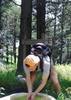
The trail fades away at another rockslide that is also very well cairned. At the bottom of this rockslide, there is some more bouldering that includes a rope strung around a boulder to help you lower yourself. After this, the creek finally levels out, allowing for some more normal hiking. At one point during this last bit of bouldering, I made the mistake of allowing my feet to get into one of the mud puddles. The mud in this creek is very slippery, hence the name Soap Creek.

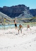
At the junction of the North and South Forks of Soap Creek, North Creek had a trickle of water, which was just enough to make the rest of the hike an exercise in trying to keep the mud off my boots. At some points it seemed almost inevitable, probably mainly due to how tired I was getting. By the time I reached the Colorado, I had drank my entire Camelback bladder, 3L.

At the river, I ate lunch, drank another liter of water, and filled up with 3 more liters. The forecasted temperature for Marble Canyon today was 100 degrees. Down at the Colorado, it was easily 110. Making my way back up Soap Creek was somewhat difficult in the unrelenting sun. The first milestone for me to reach was to get past the junction of the north and south forks, so I didn't have to keep dodging the mud.

Getting back up the big dropoff and rockslides turned out not to be as bad as I was afraid off. Some shade had crept in at that point, and as my elevation increased, so did the temps drop just enough. It also helped immensely that some clouds had drifted by just in time as I started to ascend.

At the rope, I discovered that it was great for lowering yourself, but not so good for pulling yourself up and out. I actually backed down and tried to find another way, only to find that any other route was impossible. I managed to make it up on the 2nd try, using a belly flop move to anchor my center of gravity on the upper level area, thereby preventing my falling. This resulted in my being covered in the fine dirt powder, which subsequently turned into mud as it made contact with my sweat soaked clothes and became worked into the fabric. My new white longsleeve summer hiking shirt is no longer white, and probably never will be again. [Update note: The rope ladder that is shown in older picture sets is gone now. There is only one rope that is badly placed. Be prepared for a challenge to get yourself out of this canyon, or else bring an extra rope to leave on your way down.]

Once I finished, I had a nice 5 hour drive back to Mesa, fighting winding roads, traffic, and monsoons.

My GPS lost the signal a few times in the narrow portions of the canyon, resulting in the GPS locating me at a wrong area and then back again, adding to the total mileage. Upon inspection of the route on my computer, I would guess that the total round trip mileage for this is about 10 miles.

As a sidenote, I went thru 9 liters of water on this hike, which I believe is a personal record for me.
_____________________
  1 archive
Nov 16 2006
avatar

 Guides 1
 Routes 2
 Photos 3,905
 Triplogs 154

female
 Joined Nov 23 2003
 Gold Canyon, AZ
Soap Creek CanyonNorthwest, AZ
Northwest, AZ
Hiking avatar Nov 16 2006
suzazTriplogs 154
Hiking5.00 Miles
Hiking5.00 Miles
 no routes
1st trip
Linked   none no linked trail guides
Partners none no partners
This was an incredibly fun route! The area feels and looks so pre-historic. It turned out to be much more of an adventure than we originally anticipated. The last two pictures in this set are from the campsite at Lee's Ferry. This is a must do hike!
_____________________
 
Nov 11 2006
avatar

 Guides 20
 Routes 13
 Photos 3,189
 Triplogs 451

female
 Joined Mar 31 2002
 Chandler, AZ
Soap Creek CanyonNorthwest, AZ
Northwest, AZ
Hiking avatar Nov 11 2006
desertgirlTriplogs 451
Hiking8.00 Miles
Hiking8.00 Miles
 no routesno photosets
1st trip
Linked   none no linked trail guides
Partners none no partners
Great hike to the river :)
_____________________
 
Jun 03 2006
avatar

 Guides 171
 Routes 253
 Photos 6,100
 Triplogs 1,135

44 male
 Joined Apr 03 2006
 Pocatello, ID
Soap Creek CanyonNorthwest, AZ
Northwest, AZ
Hiking avatar Jun 03 2006
PaleoRobTriplogs 1,135
Hiking2.50 Miles
Hiking2.50 Miles
 no routes
Linked   none no linked trail guides
Partners none no partners
Rimwalked another section of Soap Canyon.
_____________________
"The only thing we did was wrong was staying in the wilderness to long...the only thing we did was right was the day we started to fight..."
-Old Spiritual
My book, The Marauders on Lulu and Amazon
 
Jun 02 2006
avatar

 Guides 171
 Routes 253
 Photos 6,100
 Triplogs 1,135

44 male
 Joined Apr 03 2006
 Pocatello, ID
Soap Creek CanyonNorthwest, AZ
Northwest, AZ
Hiking avatar Jun 02 2006
PaleoRobTriplogs 1,135
Hiking2.00 Miles
Hiking2.00 Miles
 no routes
Linked   none no linked trail guides
Partners none no partners
Rimwalked part of Soap Creek and Marble Canyon.
 Geology
 Geology [ checklist ]
[ checklist ]  Brachiopod
_____________________
"The only thing we did was wrong was staying in the wilderness to long...the only thing we did was right was the day we started to fight..."
-Old Spiritual
My book, The Marauders on Lulu and Amazon
 
May 30 2006
avatar

 Photos 8
 Triplogs 1

57 male
 Joined May 24 2006
 Florence, AZ
Soap Creek CanyonNorthwest, AZ
Northwest, AZ
Backpack avatar May 30 2006
fishbikeTriplogs 1
Backpack5.00 Miles
Backpack5.00 Miles3 Days         
 no routes
1st trip
Linked   none no linked trail guides
Partners none no partners
Epic hiking and epic fishing. I ended up doing this one solo, which I do not recommend. My friend flaked at the last minute because he "had to paint the house before the new bed his wife ordered arrived." Is there some rule about painting with a bed in the house that someone can enlighten me about here? No furniture conflicts at my house, so I was not about to burn a 3 day weekend watching the zombie box (I did manage to catch game 3 of the Western Conference Finals at the Vermillion Cliffs Lodge).
I Camped at the trailhead Friday night and headed down into the canyon at first light. Wow! Incredible scenery and an equally challenging hike. This is not for the faint! Bring some rope to lower your pack and I recommend wearing gloves, your going to get on all four for this one. At times it is difficult to find the trail through the boulder fields, but look for the rock cairns, footprints in the sand, and mud stains on the rocks. You will at times have multiple paths to choose from that pretty much break down into the bouldering category or the high steep trail category. For the trip down, because gravity was with me, I took the boulder route. The hike out is uphill all the way, and because I was a wearing a heavy pack, I took the high steep trails out.
Campsite was a river front, white sand, barefoot beach, just above Soap Creek rapids on the Colorado River. This is a popular spot with rafters, so be prepared to share. I was invaded by a group from Durango, Colorado, who shared their fresh salad, fettucine and a cold beer as a peace offering for invading my camp. Thank you Eric and Lorelei for your generosity.
The last day of fishing was one of my best. It took a while to find the fish, but easily brought 20 fish to hand in an afternoon when I figured them out. I packed in waders and boots, but this gear is not necessary. Plenty of fish are accessible from the shore.
I will post pics when they are developed.
_____________________
Calmer than you are.
 
average hiking speed 1.79 mph
1, 2  Next

WARNING! Hiking and outdoor related sports can be dangerous. Be responsible and prepare for the trip. Study the area you are entering and plan accordingly. Dress for the current and unexpected weather changes. Take plenty of water. Never go alone. Make an itinerary with your plan(s), route(s), destination(s) and expected return time. Give your itinerary to trusted family and/or friends.

helpcommentissue

end of page marker