|
| | | |
| |
|
| Hiking | 8.40 Miles |
2,387 AEG |
| | Hiking | 8.40 Miles | 4 Hrs 45 Mns | | 1.77 mph |
| 2,387 ft AEG | | | | |
|
|
| |
| Linked |
|
none
[ show ]
| no linked trail guides |
| Partners |
|
none
[ show ]
| no partners | | I stayed a 2nd night in Flagstaff at the Quality Inn. Great deal $87 for 2 nights including all taxes and continental breakfast. At breakfast I met a couple from New Zealand in their 60s. They were here touring the Country and looking for a place to possibly escape the tyrannical overtake of New Zealand, which we've heard about on the news. They talked about the gun confiscations and that they no longer have freedom of speech. I told them that similar things has been happening here in the last few years. But, I suppose the main difference is most Americans will stand up to communists and fight to the death if necessary but New Zealanders won't...
Anyway, I got a last start and didn't make it to the trailhead until after 10 am. This was a very well maintained trail and I noticed there were long stretches of flat sections and some pretty steep sections scattered around, which provided good variety. At around the 2 mile mark, I saw a post that had the number "2", but didn't see a 1 or 3 mile marker anywhere. I saw 3 other hikers in the first mile of the trail, and beyond the first mile or 1.5 miles, I didn't see anyone else until I reached the road and got close to the summit. After about 2 miles, you will see a drainage to your right and the trail seems to follow that for quite a while. Eventually you will cross the drainage at around 2.9 miles, and head up near the top. There's a trail junction at 3.25 miles and that is the Bixler Trail #72. It's only a few hundred feet to a nice saddle which is a great place to have lunch if the temps are cool. If the temps are hot, just stay in the canyon or in the trees. At roughly 3.6 miles, you will reach a road. Then you will see the trail continue across the road. Take the trail which will lead up to a higher road. From here, I believe this is where the trail ends. From here, it's roughly 0.5 miles more of road to get to the summit. At the top there are some radio towers and some kind of historic sign on one of the lookout towers. There are some decent views to the South, but that's about all you can see. The day I was there, there were workers at the summit, and I didn't want to get in their way, but I was able to get to the high point and take some photos of the views. I didn't see a registry anywhere.
On the way down, I stopped at the unnamed saddle which was only a few hundred feet down the Bixler trail. It was a bit windy here, but I found a spot to have my lunch here where I was away from most of the wind. Then, I continued down the trail the same way I came. It was a bit windy at times on the way down. I saw some tall aspens mixed in with the various pines. The lower 3.7 miles of the hike is more interesting and scenic. Once you get to the road, the hike becomes less interesting and really the only point it to reach the summit and see some nice views to the South. If I did this hike again, I might stop at the road and turn back there. All in all it was a very nice hike and worth doing. |
| _____________________
Michael Williams
IT Professional
Rocky Point Vacation Rentals
Ocean Front Condo in Rocky Point, Sonora, Mexico
www.beachfrontmexico.us
 |
| | |
|
|
|
 Route Editor


 Biggest climb I’ve done in awhile. Trail was a mixture of rocky sections, root sections , steep sections, and smooth sections. So , the normal!
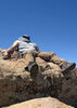
  Was pretty windy up top! Wally said if the wind caught his hat and blew him away he would see me at the bottom! I thought he was kidding but he flew down the mountain and I just saw a glimpse of him here and there!


 today!
