username
X
password
register
for free!
help
ArticlesGuidesRoutes
 
Photosets
 
 Comments
triplogs   photosets   labels comments more
Gates Pass Trail - 3 members in 16 triplogs have rated this an average 2.3 ( 1 to 5 best )
16 triplogs
login for filter options
Oct 19 2024
avatar

 Guides 93
 Routes 397
 Photos 4,984
 Triplogs 4,124

49 male
 Joined Jun 20 2003
 Tucson, AZ
Tucson Mountain Park, AZ 
Tucson Mountain Park, AZ
 
Run/Jog avatar Oct 19 2024
fricknaleyTriplogs 4,124
Run/Jog16.00 Miles 1,830 AEG
Run/Jog16.00 Miles   3 Hrs   32 Mns   4.55 mph
1,830 ft AEG      1 Min Break8 LBS Pack
 no routesno photosets
Partners none no partners
Had a much better go at it on this route than in the summer - maybe because it was 300 degrees cooler? beautiful day
_____________________
hi
 
Jan 14 2023
avatar

 Guides 16
 Routes 81
 Photos 1,269
 Triplogs 1,144

51 male
 Joined Apr 30 2008
 Tucson, AZ
Ringtail Trail - Saguaro NP WestTucson, AZ
Tucson, AZ
Hiking avatar Jan 14 2023
azdesertfatherTriplogs 1,144
Hiking2.67 Miles 174 AEG
Hiking2.67 Miles      57 Mns   2.86 mph
174 ft AEG      1 Min Break
 no routesno photosets
1st trip
Linked   linked  
Partners none no partners
Pretty boring little loop, started at the little parking area at the intersection of Kinney & Gates Pass roads. Hiked up Cougar Trail under power lines, then to Ringtail and to Orcutt. Later turned off Orcutt onto Siphon. Finished the loop by hiking Gates Pass Trail back.
_____________________
"I went to the woods because I wished to live deliberately, to front only the essential facts of life, and see if I could not learn what it had to teach, and not, when I came to die, discover that I had not lived." — Henry David Thoreau
 
Oct 31 2020
avatar

 Guides 93
 Routes 397
 Photos 4,984
 Triplogs 4,124

49 male
 Joined Jun 20 2003
 Tucson, AZ
Gates Pass TrailTucson, AZ
Tucson, AZ
Hiking avatar Oct 31 2020
fricknaleyTriplogs 4,124
Hiking2.30 Miles 92 AEG
Hiking2.30 Miles
92 ft AEG
 no routesno photosets
1st trip
Linked   none no linked trail guides
Partners none no partners
we had a little time to spare in the morning, so Sierra and I did another short hike from our camp spot using some of the trails around the Gilbert Ray campground. great morning and great quick getaway :y:
_____________________
hi
 
Mar 19 2016
avatar

 Routes 39
 Photos 353
 Triplogs 128

37 male
 Joined Sep 30 2015
 Carrboro, NC
Gates Pass TrailTucson, AZ
Tucson, AZ
Hiking avatar Mar 19 2016
afrankieTriplogs 128
Hiking0.33 Miles 97 AEG
Hiking0.33 Miles
97 ft AEG
 no routesno photosets
1st trip
Linked   none no linked trail guides
Partners none no partners
A quick scramble at Gates Pass to catch the view. It was a spandex paradise as cyclists outnumbered hikers bigtime on a gorgeous Saturday am.
_____________________
Good judgment comes from experience. Experience comes from bad judgment.
Evan Hardin

Footloose adventures are documented instagram @afrankie8.
 
Jul 28 2015
avatar

 Guides 1
 Routes 136
 Photos 1,367
 Triplogs 364

47 male
 Joined Jun 10 2011
 Phoenix, AZ
Tucson Mountains Tuesday Two-fer, AZ 
Tucson Mountains Tuesday Two-fer, AZ
 
Hiking avatar Jul 28 2015
The_DudeTriplogs 364
Hiking3.60 Miles 2,224 AEG
Hiking3.60 Miles   2 Hrs   48 Mns   1.71 mph
2,224 ft AEG      42 Mns Break10 LBS Pack
 
no photosets
Partners none no partners
Ah, first hike back in the desert after a week in Anaheim for Disney and beach fun. First off, thanks to Philbeer for posting the tracks for Golden Gate and Bren mountain last week, I saw those and it got me thinking. I have been wanting to hit Golden Gate Mountain for a while, throw in another nearby peak and I am sold. Made it out to the Yetman trailhead about 3 to start my fun for the day. The trip up Golden Gate is very steep, but easy to follow. It is a pretty thin trail in spots, but the trip up is extensively cairned, a little overkill in spots even. Nice summit with good views out to the west and south especially. The weather was getting interesting, but I thought I would have enough time for a second summit before the storm started. Made it back down to the Yetman trail and then on to Gates Pass trail for a bit. I went up the west side of Bren Mountain, and there is no trail whatsoever. I found a drainage and followed it up quite a ways, but then the rocks turned to scree and it was mighty steep. It kept getting steeper, and the lightning was looming, but I actually figured I would be safer making it to the summit and going down the backside which looked to be less steep. I ended up going up a rock face for the last 40-50' up to the peak, and I was really happy to see some semblance of a trail on the other side. Very brief stop up top to see lightning hitting on the slopes just to the east of me, all the motivation I needed to haul butt down the other side. If I hit Bren again any time soon, it will be by way of the North and East route...Made it back to the van no worse for wear other than a few scratches, I managed to miss the abundant cholla up here, but had plenty of bursage to pull out of the socks and boots. Pretty short for my usual offerings, but this one was all work.
_____________________
  1 archive
Feb 22 2011
avatar

 Routes 2
 Photos 9
 Triplogs 1

80 male
 Joined Jan 03 2010
 Tucson
Gates Pass TrailTucson, AZ
Tucson, AZ
Hiking avatar Feb 22 2011
rogaplTriplogs 1
Hiking5.00 Miles
Hiking5.00 Miles
 
no photosets
1st trip
Linked   none no linked trail guides
Partners none no partners
2011-02-22

We followed a marked trail to the summit of Bushmaster Peak as entered by hiking member Samba in a link to the Gates Pass Trail. The trail just before the saddle that leads to Tower Peak is very narrow. The trail prior to reaching the top of Bushmaster Ridge is quite steep. It is not too bad climbing up but it is more difficult descending with the combination of being steep with a lot of loose rock. We had originally intended to top Bushmaster and then come back along the trail and hike to Tower Peak. We climbed to tseveral of the peaks at the top of Bushmaster Ridge and instead of returning to the trailhead by the marked trail we bushwacked down the South face of Bushmaster leaving the marked trail at the saddle below the peak ridge. This is a considerably shorter route down. It is not too steep but there is a lot of loose rock so one has to be careful to not slide. My Gps route was recorded by a Magellan meridian gps that indicated a W.A.A.S seting. The time indicated on the GPS is not correct. We started at 8:25 AM and reached the summit of Bushmaster in 1 hour and 47 minutes. It took about an hour to get back to the trailhead by the bushwack from the saddle.
_____________________
 
Aug 28 2010
avatar

 Photos 128
 Triplogs 312

39 female
 Joined Feb 01 2007
 Phoenix, AZ
Gates Pass TrailTucson, AZ
Tucson, AZ
Hiking avatar Aug 28 2010
lb4449Triplogs 312
Hiking8.00 Miles
Hiking8.00 Miles
 no routesno photosets
1st trip
Linked   linked  
Partners none no partners
_____________________
 
Jan 22 2009
avatar

 Triplogs 17

45 male
 Joined Jan 31 2009
 Tucson, az
Gates Pass TrailTucson, AZ
Tucson, AZ
Hiking avatar Jan 22 2009
Scott7160Triplogs 17
Hiking6.00 Miles
Hiking6.00 Miles   2 Hrs      3.00 mph
 no routesno photosets
1st trip
Linked   none no linked trail guides
Partners none no partners
_____________________
 
Nov 02 2008
avatar

 Guides 34
 Routes 249
 Photos 2,197
 Triplogs 592

38 male
 Joined Aug 16 2006
 Portland, OR
Gates Pass TrailTucson, AZ
Tucson, AZ
Hiking avatar Nov 02 2008
keepmovingTriplogs 592
Hiking0.50 Miles
Hiking0.50 Miles
 no routes
1st trip
Linked   none no linked trail guides
Partners none no partners
No Notes.
_____________________
 
May 31 2007
avatar

 Photos 95
 Triplogs 28

42 male
 Joined May 09 2007
 Tucson, AZ
Gates Pass TrailTucson, AZ
Tucson, AZ
Hiking avatar May 31 2007
SjcorreaTriplogs 28
Hiking3.50 Miles
Hiking3.50 Miles
 no routesno photosets
Linked   none no linked trail guides
Partners none no partners
_____________________
 
May 29 2007
avatar

 Photos 95
 Triplogs 28

42 male
 Joined May 09 2007
 Tucson, AZ
Gates Pass TrailTucson, AZ
Tucson, AZ
Hiking avatar May 29 2007
SjcorreaTriplogs 28
Hiking3.50 Miles
Hiking3.50 Miles
 no routesno photosets
Linked   none no linked trail guides
Partners none no partners
_____________________
 
Feb 03 2007
avatar

 Triplogs 52

50 male
 Joined Sep 14 2004
 Phoenix, AZ
Gates Pass TrailTucson, AZ
Tucson, AZ
Hiking avatar Feb 03 2007
SkervyTriplogs 52
Hiking5.00 Miles
Hiking5.00 Miles
 no routesno photosets
Linked   none no linked trail guides
Partners none no partners
Not sure if this was the exact trail I took but I took off from this trailhead. Meandered south towards some retirement community and then eastish up over some ridges and then back to the jeep. Probably closer to 6 miles than 5.
_____________________
 
Dec 23 2006
avatar

 Triplogs 52

50 male
 Joined Sep 14 2004
 Phoenix, AZ
Gates Pass TrailTucson, AZ
Tucson, AZ
Hiking avatar Dec 23 2006
SkervyTriplogs 52
Hiking5.00 Miles
Hiking5.00 Miles
 no routesno photosets
Linked   none no linked trail guides
Partners none no partners
I guess this was the hike I did.

I started out at the Gates Pass trailhead under a thick layer of early morning fog. Initially, I hiked up to the junction and then made a right and started my way around the mountain. About halfway (I think) I turned back and returned to the junction. From there I took the Golden Gate trail (or what there is of it) towards the upper parking area. Along the way I climbed some rocks and took a few minutes to watch the fog settle in Avra valley. It looked like a sea of clouds with mountain islands poking through. I walked all the way down to the parking area climbing whatever peak that is just south of it. Saw two nice size does along the way and could have been eating good for a year if I had a bow.....
After reaching the parking area I went back down around the backside of the hills bushwacking all the way. Think I startled a couple of tourists in the parking lot when I came flying out of a wash.
_____________________
 
Sep 01 2004
avatar

 Triplogs 2

56 male
 Joined Aug 09 2004
 Tucson, AZ
Gates Pass TrailTucson, AZ
Tucson, AZ
Mtn Biking avatar Sep 01 2004
Luno De DiabloTriplogs 2
Mtn Biking5.00 Miles
Mtn Biking5.00 Miles   1 Hour   15 Mns   4.00 mph
 no routesno photosets
Linked   none no linked trail guides
Partners none no partners
Park at the G5 parking area, directly North from Climbing Boulders(biggest rocks). This is the second parking PULLOUT after passing the parking LOT (G1) mentioned in directions. This is all time great INTERMEDIATE level mountain bike xc riding.
If starting at that first bottom parking LOT G1, ride up saddle to meet Yetman Trail. Turn right onto Gates Pass trail, then descend one of the most technical, ledgy, stepped switchbacks in the area. ADVANCED RIDERS ONLY. Prepare to loose your knobbies.

OR as for this description, departing south on the trail across street from the G5 pullout takes you to the intersection of Gates Pass Trail at the Climbing boulders. Turn right at the cairns before steps. As mentioned before this trail is treacherous. DO NOT RIDE WITHOUT HELMET. Palo verde notorious Arizona pinstripers, jumping teddy bear cholla, waving prickly pear and saguaro's standing proud in your face. Even Jojoba offer delicious trailside treats. As mother nature has been trying to tell us all along, balance is key. After 45mins/1.25 miles of descending reached the asphalt road.
Turned right, heading west on Kinney road. Pass the Iron wood picnic area entry on left. Continue 0.4 mile on Kinney Road. Turn left, south, at opposing parking pullouts. Drop onto sandy "Sweet" trail from south corner of pullout. Moderate speeds weaving around cacti and wash switchbacks. After twenty minutes drop into small sharp wash. Be prepared to turn left at next trail, drop down steep wash. Exit wash under last and largest Ironwood in the picnic area. Did you miss turn and end up at fork into double track? Turn back if so.
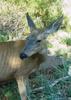
Turn left, north, and head 0.75 mile back uphill over speed humps to entry on Kinney Road. Turn left, westbound on Kinney road. Return 0.4 mile to opposing pullouts. Turn right, leaving north pullout onto Ironwood Trail. This sandy double track is more strenuous than technical. Scratched passed a Palo verde, when I noticed a cholla stump in the trail. Dodge those hissing thorns. Slithering fat footer Gila was orange with black spots. It stopped running when I dismounted. As I took a step towards from ten feet away it hissed. It then predatorily moved on. Did I really even want to get closer? Whiff it's mega bacteria laden breathe, not to mention they don't let go when they bite. Move on little dude.
Rode straight through the sandy wash, and then straight up the trail, where the upstream wash bears right. Made it back up to Gates Pass Road after 30 mins on Ironwood trail. Turned right, east, and pedaled uphill to G5 parking pullout.

For abbreviated ride, exclude "Sweet" portion, turning right at opposing pullouts. Leave at least one hour prior to sunset. If not bring flashlight for emergency. Game wardens do not like stragglers in the Tucson Mountain Park. Beware they are strict after dark. Animals complain about the noisy invasive humans.
_____________________
 
Aug 29 2004
avatar

 Triplogs 2

56 male
 Joined Aug 09 2004
 Tucson, AZ
Gates Pass TrailTucson, AZ
Tucson, AZ
Mtn Biking avatar Aug 29 2004
Luno De DiabloTriplogs 2
Mtn Biking5.50 Miles
Mtn Biking5.50 Miles   1 Hour   30 Mns   3.67 mph
 no routesno photosets
Linked   none no linked trail guides
Partners none no partners
Gates Pass Trail is an all time thread the needle through the gap o' cacti, dropping off rock erosion guards and in between natural outcroppings. The +1 mile rolling 4% grade makes this one scenic descent, even for ADVANCED beginners. Make no mistake every thing will make you bleed if you hit it. Thorn proofs are the only way over cholla and prickly pear pads. Switchbacks occur at all the wash crossings. Ascents up the otherside require technical balance.
After one mile, reached Kinney Road. I headed straight across the road through the acacia. Very scratchy. This ADVANCED technical route is the beginning of Prospector's Trail. You will need mule legs to make it up this bushy scree ascent. Very loose rock more suited to hiking. Descending from the saddle, loose scree again, I slid over more natural outcroppings. Fields of teddy bear cholla glistening in setting sun begged for photographs. Took the first right turn heading down west to the south end of Ironwood Picnic Area.
The next thing I knew I was facing a pack of 4-5 scattering coyotes. They ran to the edges, stopping to watch me. Glad they couldn't read the Beef Jerky label. As a practicioner of minimal disturbance I would not have gotten so close so fast, just couldn't see them as was approaching from east with sun in my eyes.
Last approach to picnic area is deep sandy. Crossed under the big ironwood then began trail ascent up to Kinney Road. "Sweet trail was meant to be ridden one way and this wasn't it.
At Kinney Road crossed directly over to parking lot then through opening on left. The last 1.5 miles back up is only 4% but on sandy double track. Good cardio spot for trail runners as well. Went straight in sandy wash. Continued straight onto trail where upstream wash turns right. In less than a quarter mile was back onto Gates Pass Road. Turned right back up to car. Ended with spectacular sunset.
_____________________
 
Feb 15 2003
avatar

 Guides 1
 Photos 185
 Triplogs 20

70 male
 Joined Feb 28 2003
 Glendale, AZ
Gates Pass TrailTucson, AZ
Tucson, AZ
Hiking avatar Feb 15 2003
fatoldsunTriplogs 20
Hiking3.00 Miles
Hiking3.00 Miles   2 Hrs      1.50 mph
 no routes
1st trip
Linked   none no linked trail guides
Partners none no partners
We didn't make it all the way around because of time issues but I will make it back again to completely check this out. I have to say what made this hike extra speical was not only the terrain but something completely independent of the terran surroundings which was the cloud cover was spectacular on this day as can be seen in the photos. There were cloud bursts everywhere with the sun breaking through creating beautiful bright rays making the sky look like heaven. No other way to put it. :wink:
_____________________
 
average hiking speed 2.27 mph

WARNING! Hiking and outdoor related sports can be dangerous. Be responsible and prepare for the trip. Study the area you are entering and plan accordingly. Dress for the current and unexpected weather changes. Take plenty of water. Never go alone. Make an itinerary with your plan(s), route(s), destination(s) and expected return time. Give your itinerary to trusted family and/or friends.

helpcommentissue

end of page marker