|
| | | Fishing for Sandys Walnut, AZ | | | |
|
|
Fishing for Sandys Walnut, AZ
| | |
| |
|
| Hiking | 9.00 Miles |
1,075 AEG |
| | Hiking | 9.00 Miles | | | |
| 1,075 ft AEG | | | | |
|
|
| |
| Partners |
|
[ show ]
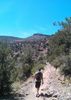
| partners | | Another that has been on my list for a long time. I meant to go last week, but couldn't get out. Decided that the LosDosSloFolks might like this one, so sent out the invite. I've changed my Hiking day to Wednesdays due to crowds on Fridays, but still start early to try to avoid people in the morning at least. And that high elevation sun does get pretty intense in the afternoons if there's no shade. Most don't like to start that early especially when you figure in the drive. Greg and Cathy are no exception, but they decided to humor me. I looked at the Forecast and the high was supposed to be 80 with a low that morning of 38. At 5:00 a.m. in Mund's Park, it was 50 degrees. I was impressed. It wouldn't last long. Dinking around Lake Mary before our meet time at 6:00, I wore a heavier jacket. Lots of Elk and Deer spotted along the road. I had to stop for a herd of about 25 Mule Deer crossing the road at one point. Eagles and Osprey at the Lake.
Got to the TH and met up with the Crew and John, their friend from Williams. It was 28 degrees. Decided since I would be moving, I could get away with the lighter sweatshirt, but donned gloves. Hands still eventually got cold the first 45 minutes until we hit sun. But it was perfect after that until just before we finished midday, as the sun got really warm. 80 up there, feels like 95 down here. Thinner air, higher elevation, more intense sun.
When I planned this, I tried really hard to make a loop out of it, scrutinizing possibilities to get down into Walnut and then back up the other side. But nothing looked very promising. I did, however, plan the Hike above, to where I ended at a side canyon going down into Walnut. It had possibilities and I thought I'd go that far and at least check it out. Greg and I talked about it before the Hike and decided that we might split up for a bit, if I wanted to go that far. They were about walking up into the Canyon itself. He did challenge himself to get up to Fisher Point and he was not the only one that enjoyed that portion of the Hike. Just a beautiful area.
I told Greg and company to take their time going back down and into Walnut Canyon and I would catch up with them down there. I had 1 1/2 miles to go from Fisher, to get to the other side Canyon, so I figured if I hustled to do the out and back, I would only be an hour behind the crew when trying to catch up. The tread along what is the Arizona Trail to that side canyon turn around point was pretty decent and I made good time. When I got there, I wanted to take a good look at it. From the top going down actually didn't look too bad and there was a game trail, which gave me hope. My concern was going to be the last 200 feet or so and wondering about cliffing out. Although, I felt like I needed to start heading back, curiosity got the best of me and I figured that if I COULD get all the way down, then I would actually be ahead of the rest of the crew. So I started following what appeared to be a deer trail. If the Wildlife were going to pick a Canyon to get all the way down to the bottom of Walnut, it would be this one. This was no steeper than some of the approach hikes I've done to technical sections of canyons, so I treated it as such and was happy for the practice. That doesn't mean it wasn't plenty steep.  And it got steeper. There were 2 spots that almost had me turning around as I appeared to be cliffed out. But I managed to find a way to get it done and in those spots, there was only one way. And I made damn sure that I could get back up what I was going down, just in case I could go no further. It took me about 45 minutes, but I got down. Only 2 remotely "sketchy" spots, but more so just because I was alone and travelling an unknown. But I was comfortable with both of those places. Just before the very bottom, I encountered a bear's morning dump. And it got steeper. There were 2 spots that almost had me turning around as I appeared to be cliffed out. But I managed to find a way to get it done and in those spots, there was only one way. And I made damn sure that I could get back up what I was going down, just in case I could go no further. It took me about 45 minutes, but I got down. Only 2 remotely "sketchy" spots, but more so just because I was alone and travelling an unknown. But I was comfortable with both of those places. Just before the very bottom, I encountered a bear's morning dump.  But the Deer were the ones that ultimately showed me the way. But the Deer were the ones that ultimately showed me the way. 
Since I had never been to Walnut Canyon before, I wasn't sure if there was even a Trail this far into it. At first I didn't see one so I figured I'd have to just off-trail/bushwack for a bit, but then within 200 feet of hitting bottom I encountered a really nice single track. I guessed that I was actually "ahead" of the rest of the crew, so I started going down canyon back towards Fisher. I hadn't told the Crew that I was going to try to descend into Walnut, because well, I hadn't planned on it. So I knew when I ran into them, they would be surprised. And they were. Greg came around the corner first and his expression was priceless.  There was shade right there, so I took a small break. That last 45 minutes had been a bit strenuous. There was shade right there, so I took a small break. That last 45 minutes had been a bit strenuous.
The Crew was getting a bit tired as well and thought that our rendezvous point was a good turn around spot. So we continued down canyon and just enjoyed the day. The Cliffs and Alcoves in this Canyon were pretty cool. Some of the Alcoves might be considered Caves, but they didn't go back very far. Really neat area, with a Riparian feel in places even though I didn't see any running water in there. Tons of birds and butterflies on this entire hike and some were pretty special. As we got closer to the TH, we started running into more and more people heading in. It was really quite warm in the sun by then and a cold drink and a late lunch was sounding really good. The TH parking was overflowing when we hit the Vehicles.
Finished up the Hike, got some excellent Mexican Food in Flag and then parted ways. Everyone headed for home but me. I drove back down into the Lake Mary area to do some more exploring and maybe see a Common Crane at Mormon Lake. I took a back way to get to Lake Mary, taking 128 from almost I-40, down to Lake Mary Road, around Marshall Lake. I could not believe how many people were camping on the second half of that stretch. When I got to Lake Mary, many of the parking lots were also full with lots of people on the Lake. Spent a bit of time at Lake Mary and then at Mormon Lake before heading home via Happy Jack and then over to Camp Verde to hit the 17. Nice Drive and I minimized the Elk/Road encounters although one motorist and elk wasn't so lucky. The only downfall of driving Rim and Flag country at dusk into darkness. It really makes me nervous at times.
It was a really good day. The best I've had in awhile actually. Got some mileage in, some off-trail work in, some amazing wildlife encounters in, and best of all, some laughter, which is by far the rarest experience right now. I'm so glad to have had the company on this one and they were awesome! Thanks guys! Until next time!
Fauna documented through Photos
Mammals: Mule Deer and Elk
Birds: Osprey, American Crow, Common Raven, Bald Eagles (Adult Pair and Fledglings), Juvenile Black-headed Grosbeak, and Mexican Spotted Owls (Probably Male and Female Pair)
Butterflies: Painted Lady, Southwestern Azure, Western Pine Elfin, Silver-spotted Skipper, Ilavia Hairstreak, Arachne Checkerspot, Common Buckeye, Weidemeyer's Admiral, and California Tortoiseshell.
Other: Grasshoppers and Plateau Fence Lizards. |
|
Wildflowers Observation Light
Lupine, Indian Paintbrush, some yellow, some white and some other blue/purple. Just enough to enjoy. It'll be a bit before you have the option of tiptoeing through it all yet. |
|
| _____________________
| Life is not a journey to the grave with the intention of arriving safely in a pretty & well preserved body, but rather to skid in broadside, totally worn out & proclaiming, "Wow What a Ride!" |
| | |
|
|
|
 Route Editor