username
X
password
register
for free!
help
ArticlesGuidesRoutes
 
Photosets
 
 Comments
triplogs   photosets   labels comments more
Four Peaks Mother Lode - 33 members in 121 triplogs have rated this an average 4.7 ( 1 to 5 best )
1, 2, 3, 4, 5 ... 7  Next
121 triplogs
login for filter options
Oct 26 2024
avatar

 Photos 15
 Triplogs 1

63 male
 Joined Jun 05 2012
 Phoenix, Az
Four Peaks Mother LodePhoenix, AZ
Phoenix, AZ
Hiking avatar Oct 26 2024
HzrInAzTriplogs 1
Hiking8.62 Miles 3,648 AEG
Hiking8.62 Miles   8 Hrs   49 Mns   1.28 mph
3,648 ft AEG   2 Hrs   6 Mns Break
 
1st trip
Linked   none no linked trail guides
Partners none no partners
Route Scout Route Recorded  on Route Scout | Pop | Map | Popup | MapDEX
Road conditions were good. We (2) started from the browns peak trailhead at 6:30 am. We did the route as 4,3,2,1 reaching amethyst was pretty straightforward as was going back over to Sister. From Sister to Brother was more challenging as far as route finding. We stayed to the east side after the saddle and climbed to the Brother summit from this side. Staying in the draws meant fighting the manzanita so it seemed easier to scramble the rock faces. We then went straight down towards Browns and up the se face there. About 8:45 car to car with breaks at each peak. A fun, challenging day of route finding, bushwhacking and scrambling.
_____________________
 
Jun 23 2024
avatar

 Photos 52
 Triplogs 7

male
 Joined Mar 02 2008
 Queen Creek, Az
Four Peaks Mother LodePhoenix, AZ
Phoenix, AZ
Hiking avatar Jun 23 2024
davidsnazTriplogs 7
Hiking8.30 Miles 4,600 AEG
Hiking8.30 Miles   8 Hrs   7 Mns   1.22 mph
4,600 ft AEG   1 Hour   20 Mns Break26 LBS Pack
 no routes
1st trip
Linked   none no linked trail guides
Partners none no partners
Solo Trip today across the the ridgline. As I was alone today and had not previously experienced this route I carted along gear for potential technical access in case I needed to bail somewhere along the way.

I started off just after six to the occasional patter of rain drops. Fortunately the rain never developed or my plans certainly would have had to change. I reached the saddle around a quarter to seven and continued on the Amethyst trail to some point before it reached the mine area. I found a loose drainage and made my way down and around the mine. I can't say I would recommend this as it was either loose rock or dense brush for a decent stretch. I then came to another gully that lead up to the Southwest side of Amethyst Peak. Seeing a section above where I would be walled out I made my way out and up onto one of the shoulders. Most of this area was class 4 scrambling with some areas of significant exposure. There were a couple of short sections of low class 5 that were short lived. I backtracked a few times to avoid significant climbing and potential consequences.

Roughly around 9:30 I reached the top of the peak and took some time to take in the views. The clouds added to the scenery and kept the peaks in the distance from washing out.

With the sweat nearly dry I continued down toward Sister Peak. This seemed pretty straightforward and in about 45 minutes I found myself once again surrounded with the beautiful panorama.

As many have stated the hop between sister and brother is truly where the fun is. I definitely felt the elevation on that one. As I was going up the slabby section on the east side of Brother I could feel the effects of excessive sweating starting to manifest in my foot. Upon nearing the top my quad began to quiver on the bigger steps. At this point I knew I needed to stop and load up on salt.

I took a long break at the peak and let everything catch up as I watched the piles of ladybugs moving around on the grass.

The cross over to Brown's was much more straightforward than between the other peaks but still took quite a bit longer than I was expecting. Seven hours in I reached the final peak. After updating my wife on my progress and downing water I was ready to get back to the truck. The chute seemed more loose than the last time I was up there but that's probably just my faded memory.

It was probably due to tired legs but for some reason the coming down the chute seemed like the worst part of the day. I ran out most of the last two miles and surprised my second rattler of the day. Running past I never saw it but the one earlier made my heart skip a beat. It was thoroughly annoyed with my presence and continued to make that clear even after I was well away.

All in all it was a beautiful day and the weather held out wonderfully. I was surprised to see two speckled frogs coming down between Sister and Brother. The best moment though was the time spent being watched and watching the hummingbird that landed near me. I've never seen one land and stay put for so long before. I'm glad I finally got this one done. It might be a bit but I'll definitely be back.
wildflower observationwildflower observationwildflower observationwildflower observationwildflower observation
Wildflowers Observation Isolated
_____________________
 
Apr 22 2023
avatar

 Triplogs 1

male
 Joined Apr 19 2023
 
Four Peaks Mother LodePhoenix, AZ
Phoenix, AZ
Hiking avatar Apr 22 2023
thathumbleTriplogs 1
Hiking8.30 Miles 4,600 AEG
Hiking8.30 Miles   14 Hrs   4 Mns   0.59 mph
4,600 ft AEG20 LBS Pack
 no routesno photosets
1st trip
Linked   none no linked trail guides
Partners none no partners
First note is that we paid for contributor access to get the route from this website, and staying on the tracks kept us off the sketchy/exposed areas and was probably the only reason we made it through. I highly recommend becoming a contributor to download the official route for offline use. You’ll need the Route Scout app, but that’s free.

We were a group of two and took the 4-3-2-1 route. We left the Lone Pine trailhead at 4:10 am. Get up to Amethyst with what you are comfortable doing, we’ll leave it at that. We made the summit at 7:07 am. Bring gloves because we ended up pushing through brush for long portions and kept them on nearly the entire time we were doing the Motherlode.

Coming off Amethyst we went to the east of the saddle to approach Sister. We got off the tracks a little and while trying to climb up we hit a slab that seemed too exposed to us. We looked back at the tracks and saw that everyone was clearly skirting this slab based on the big ‘U’ shape going around it. We backtracked, got back on the tracks, and found a really easy chute with basically no exospore and we were up Sister surprisingly fast. We had been worried about getting up Sister based on what we saw in videos, but it really wasn't bad at all.

Made it to the summit of Sister at 9:42 am. On the top of Sister, we saw people going up Amethyst on the legal route. They were on a spine with drops on both sides and were clearly good climbers moving like mountain goats. We also saw people at Brown’s and only Brother didn’t have anyone on it. Another interesting thing that happened is that we heard a helicopter and spotted it below us, heading to the mine.

Down Sister was the start of where it got stressful and stayed that way until we got to the saddle between Brother and Brown’s. We initially tried to stay on top of the ridgeline like the suggested route told us, but the exposure on both sides got to us. We decided to take an alternate route (still on the official route), backtracked, and went down the west side. We were able to follow these tracks north until we found a chute going up to the saddle between Sister and Brother. This saved us exposure and got us back to where all the tracks converge before starting properly on Brother.

Like everyone else says, absolutely stick to the eastern side of Brother. You basically stay on the same elevation as the saddle and just move north. This is the first time you can actually see a path every now and then, so stick to this. Looking at the official route, the first approach to the peak of Brother is the scramble if you want to climb. If you keep moving north before heading up, like we did, you can go straight up with less exposure (on the official route as well). Moving along the side of the ridge for so long was very annoying, and there was a lot of crawling through bushes. The bushes are annoying to break through, but also if you slip they catch you, so a love/hate relationship. Our push up Brother was really strenuous. We basically targeted where bushes were because it means there was enough flat ground for them to grow, and again the bush can catch you.

We finally made the peak of Brother at 2:07 pm, almost 5 hours since we were on the last peak. We took so long that my wife messaged my inReach to make sure we were still okay. While we were resting the group behind us caught up. They were a group of six and had taken the scramble up Brother. This group was much more experienced than us as climbers, while I consider myself a hiker first. Another guy showed up that was coming from Brown’s so we now had a group of nine that was all heading back together to the last peak (Brown’s).

We let everyone else lead since they were all better climbers than us, and this is where the only actual climbs of the route are. Down Brother had the most exposure of anywhere else on the Motherlode. All of it except for one section is still scrambling. The only climbing portion was very short with good handholds but had enough of a drop behind you to make you nervous about it. Having seen eight others do it ahead of me gave me a lot more confidence than if it had only been the two of us. We were down Brother quickly and started to go up Brown’s.

We took the middle chute up Brown’s and were up so fast I thought it must have been a false summit, but we finally bagged the final peak at 4:02 pm. The route down Brown’s is enough to be annoying at the end of the day, but we finally made it back to the trail and I was happy to finally be walking upright again.
Made it back to the trailhead at 6:14 pm, over 14 hours since we left that morning. This was the most stressful thing I have ever done for “fun” and I’m glad I did it, but I’m never doing the Motherlode again.
 
Nov 06 2021
avatar

 Photos 27
 Triplogs 9

31 male
 Joined Jun 08 2016
 Peoria, Arizona
Four Peaks Mother LodePhoenix, AZ
Phoenix, AZ
Hiking avatar Nov 06 2021
sdudzinskiTriplogs 9
Hiking8.30 Miles 4,600 AEG
Hiking8.30 Miles
4,600 ft AEG
 no routesno photosets
1st trip
Linked   none no linked trail guides
Partners none no partners
First time doing the Motherlode. We opted to go North to South because we wanted to avoid the private property and thought a downhill scramble would be easier than uphill when connecting the Ridgeline to the trail. We camped at the TH on the night before and started the hike at 6:00am. We followed the GPS track from this website and it was a BIG time saver. I think this traverse was not as difficult as others have said because we just had such good beta from all you helpful folks. We descended Amethyst Peak via this sketchy side drainage in order to avoid the mine. The recent fire burns and brush made the descent kind of miserable. We summited Amethyst Peak by 1:00pm but got back to the car by 4:45pm. We could have made way better time if there was a more useable (and legal) route to connect to the Amethyst trail.
_____________________
 
Sep 23 2021
avatar

 Guides 64
 Routes 1,124
 Photos 1,325
 Triplogs 1,437

male
 Joined Jan 01 2023
 Arizona
Brown's PeakPhoenix, AZ
Phoenix, AZ
Hike & Climb avatar Sep 23 2021
pseudalpineTriplogs 1,437
Hike & Climb8.40 Miles 3,830 AEG
Hike & Climb8.40 Miles   8 Hrs   52 Mns   1.24 mph
3,830 ft AEG
Solo  • Boulder
 
  2 archives
Apr 25 2020
avatar

 Guides 1
 Routes 269
 Photos 613
 Triplogs 1,360

50 male
 Joined Dec 22 2003
 Tucson, AZ
Four Peaks Mother LodePhoenix, AZ
Phoenix, AZ
Hiking avatar Apr 25 2020
RedwallNHopsTriplogs 1,360
Hiking7.80 Miles 4,060 AEG
Hiking7.80 Miles   11 Hrs      0.71 mph
4,060 ft AEG
 no routesno photosets
1st trip
Linked   none no linked trail guides
Partners none no partners
Can't believe i've waited so long to do this. What a great day! Only one sorta routefinding issue between #2 and #1 - ended up breaking out the webbing for a downclimb. Otherwise nothing seemed too terriby sketchy.
_____________________
  1 archive
Apr 18 2020
avatar

 Triplogs 1

male
 Joined Apr 19 2020
 Arizona
Four Peaks Mother LodePhoenix, AZ
Phoenix, AZ
Hiking avatar Apr 18 2020
bdmursetTriplogs 1
Hiking8.75 Miles 3,200 AEG
Hiking8.75 Miles   8 Hrs   30 Mns   1.03 mph
3,200 ft AEG
 no routesno photosets
1st trip
Linked   none no linked trail guides
Partners none no partners
This is the traditional 4-3-2-1 approach. We hit the trailhead at 6AM and headed out to the Amethyst mine. About two miles in there’s a post with trail descriptions. Continue right. Follow the trail until you’re almost at the base of Brown’s. There’s a campsite and a trail heading south that can be hard to miss. Make your way to the Amethyst mine, go around the ‘no trespassing’ fence and start heading up the chute, left of the building. The chute took us 30-40 minutes to get up. Try and stay right as this will save time once you start heading up to peak 4. Rather than going more so along the eastern side of 4, we headed up early off the chute up a safe route heading south. After we got to the top of the false peak, we simply made our way along the ridge east up to the peak. Either way, getting up to 4 is pretty self-explanatory. This is a great time to study the other peaks and potential routes.

Coming off 4, we advise staying as high as possible along the ridge line. Get to the base of 3 and find a solid route more so along the east side. The west side contains more sheer cliffs. Any route you take up the side of 3 will start to get more technical and into some borderline class 4 spots. Once you’re high enough on 3, the ridge line is simple to follow over to the summit. We made it up to 3 to find another ammo can and a flag. Study peak 2 really good, this is obviously the hardest one. We suggest not taking the distinct Pete’s Reverse Z ramp, as tempting as it may be. You will know the slab when you see it. We decided to try for a safer route.

Coming off 3 can be a bit of a challenge. The east side of it looked pretty sketchy to us so we tried our luck on the northwestern part. Try and come off 3 heading straight north but veer west a bit to avoid some other cliffs. At this point, we headed straight for the bottom of the Reverse Z, at the base of 2. We did not ascend up the Reverse Z, for good reason. We ascended and wrapped around 2 along the east side. Almost exactly halfway around the East side, we felt it was safe enough to ascend straight up to the summit. This part is class 3 & 4 scrambling up rocks with great holds. We went straight up and arrived exactly at the summit of 2 to find another ammo can. We made it up peak 2 in about 1 ½ hours.

Follow the rocky ridge off 2 until it ends with an abrupt cliff northernly. Keep in mind, the east side of this ridge will be about a 50-foot drop, but the ridge is safe to hike along. Make your way off that, descending down the west side and heading directly north. At this point, there will be a few spire formations and small peaks that we avoided going over. It’s best to stay along the base of them along the east side. Spiraling up the east side of peak 4, was almost a clear trail. Well, a clear trail for this kind of hike that is. Similar to our approach on 2, we wrapped about halfway around the east side of 1 and climbed straight up. Any farther east around 1 toward the northern side would’ve offered a sketchier climb. Descend off peak 1 directly west. There will be a distinct chute to descend down. After you get to the bottom, it’s about two miles till the parking lot. Round trip, we made it in about 8 hours and 30 min.

Overall, this hike/climb is a blast if you treat it that way. It can actually be fun route finding if you’re smart about it. Going with two people makes it a lot easier to scope out routes. It would be great if this route was groomed someday and became more popular!
 
Apr 11 2020
avatar

 Guides 1
 Routes 168
 Photos 384
 Triplogs 161

32 male
 Joined Aug 13 2017
 Tempe
Four Peaks Mother LodePhoenix, AZ
Phoenix, AZ
Hiking avatar Apr 11 2020
clayncallawayTriplogs 161
Hiking9.21 Miles 4,367 AEG
Hiking9.21 Miles   10 Hrs   52 Mns   0.85 mph
4,367 ft AEG10 LBS Pack
 
1st trip
Linked   none no linked trail guides
Partners none no partners
I have been meaning make triplog entries on Hike AZ for some time, and I figured I would start with the Mother Lode.

Before 4/11, I had hiked Brown's peak once, and made one attempt at the Mother Lode in a 1-2-3-4 fashion. The 1-2-3-4 attempt was not pretty. We bagged 1 and 2 in a timely manner but really struggled down 2. We eventually hit the saddle and realized shortly after that we should stop. In retrospect, I am glad we did.

This trip we decided to do the 4-3-2-1 approach. We started at just before 7 AM and hit Amethyst Peak by 9:30 AM. We ran into another group that had done the ML before while we were coming down Amethyst. The group quickly passed us on the way down 4 and we were fortunate enough to see where they started the more technical sections of peak 3. Just as we started getting into the heart pounding moves up peak 3, clouds moved in and snow started to fall. We bagged peak 3 as the weather conditions worsened.

As we started our descent down peak 3, the sun began to shine. We made it to the spot we had turned back in the 1-2-3-4 approach and breathed a sigh of relief. We made excellent time down to the saddle between 3 and 2, took a short break, and started the hike around the east face of 2. We caught a glimpse of one of the hikers from the group ahead of us making an ascent straight up the "ramp" of peak 2 (pic included). It was incredible. Peak 2 was slow but nothing compared to our previous attempt. Peak 2 was ours.

The descent of peak 2 was quick on the knife edge but I accidently led us too far down and to the east and we paid the price. The only upside was that we found a phone that someone had dropped in the area earlier that day. The phone was successfully returned to its owner on 4/12! Anyway, down peak 2 was slow. We finally we got back on track and went thru the window rock formation.

Our ascent up peak 1 was quick and we were ready to be done. We bagged Brown's just as more rain/sleet/snow started coming down. We went down the chute and back to the car! When I hit stop on my Suunto it was 5:45 PM.

Overall this hike was difficult but very fulfilling. I don't see myself doing it again. HA
_____________________
 
Oct 19 2019
avatar

 Guides 1
 Routes 1
 Photos 44
 Triplogs 38

35 male
 Joined Feb 01 2013
 Tucson, AZ
Four Peaks Mother LodePhoenix, AZ
Phoenix, AZ
Hiking avatar Oct 19 2019
jajohnson11Triplogs 38
Hiking8.30 Miles 4,600 AEG
Hiking8.30 Miles
4,600 ft AEG
 no routesno photosets
1st trip
Linked   none no linked trail guides
Partners none no partners
Did this in October of last year and am just getting around to posting a trip report. What an awesome adventure! Maybe one of the funnest hikes AZ has to offer outside of the Grand Canyon. My buddy Trevor and I wore Gaiters for this one. My last attempt of this earlier in 2019 saw my wife Stephanie and I run into TWO black rattlers, the first of which Stephanie almost stepped on and caused her to take a nasty four foot spill. The climbing can be kept to class 4, but beware all the loose rock as usual for off trail peaks. Take the helmet, bring your gloves, and wear pants! 4/4 stars for this one. If I do it next time I'll be sure to try Pete's backwards Z ramp to spice things up a bit!
_____________________
 
Jun 04 2019
avatar

 Triplogs 1

47 male
 Joined Oct 13 2016
 Gilbert, AZ
Four Peaks Mother LodePhoenix, AZ
Phoenix, AZ
Hiking avatar Jun 04 2019
brantwTriplogs 1
Hiking7.80 Miles 4,060 AEG
Hiking7.80 Miles
4,060 ft AEG
 no routesno photosets
1st trip
Linked   none no linked trail guides
Partners none no partners
First, thank you for the beta posted on previous triplogs and the GPS route that I downloaded and used via Route Scout app.

I hiked the four peaks on 5/27/2019 starting with Amethyst, the most southern, and in order of 4-3-2-1. My Strava app logged 9.7 miles and 4,332 vertical feet. I began at Lone Peak Trail Head at 6am and returned 7hr and 45 mins later. Temps were in the 40's (f) throughout the morning, tons of wind, overcast (only over the peaks though) and there was a chance for rain. Perfect!

I made it to the summit of peak 4 (Amethyst) in 2.5 hrs. Very windy and cloudy. From the summit of peak 4 I could not see the saddle between peaks 3 and 4, nor any other peak. Heading down to the saddle from peak 4 I tried not to follow the GPS. This lead to some wandering and descending below the saddle, resulting in the need to hike back up. This added a lot time.

I eventually had to use the GPS to find the path that started up to peak 3 from the saddle. Shortly after starting on the path I climbed up an alternate route to the main ridge and headed north to the summit instead of traversing along the western side of peak along the GPS route. I don't advise this if you are uncomfortable climbing class 5.5 or 5.6 rock with exposure. For me this was a very straighforward way to the top. I can't speak for the GPS path, but this route has some fairly technical sections so be aware. At 3hrs and 50 mins I made it to the summit of peak 3 (sister). From the summit it was still cloudy and the saddle to north and peak 2 were not visible. Descending peak 3 to the north I descended too much on the west side and ended up hiking back up a gulley on the south side of the prominent towering rock feature in the middle of the saddle. I believe the GPS route will keep you a bit higher on the north ridge of peak 3 and you can avoid the bushwhacking. Despite this detour the traverse over to peak 2 was not that bad in terms of finding and following a path, mostly because I think the weather was clearing and once I crossed the saddle between peaks 3 and 2 I could start to get a view of the east side of peak 2 and where to go up. By this time my phone battery was at 10% so i was not checking the GPS.

I arrived on the summit of peak 2 in just under 6 hours. Although the skies were clear by this point I didn't stay long. I descended north along the ridge until I almost came to the cliffs that descend to the east. There was an obvious opening in the cliff where it looked like a good place to descend. It seemed further down than what I thought was possible, having vaguely scouted a route from Browns peak on previous hikes. The down climb through the opening in the cliff was the sketchiest of the entire hike for me. Lots of loose rock and steep drops. On the way up to Browns (peak 1) I wandered a bit looking for the path that started the steep climb up. Once I found it, it brought me up just east of the Browns peak summit.

I loved this hike and plan to return.
_____________________
 
Mar 31 2018
avatar

 Guides 38
 Routes 186
 Photos 1,628
 Triplogs 240

male
 Joined Dec 09 2014
 Gilbert, AZ
Four Peaks Mother Lode Attempt, AZ 
Four Peaks Mother Lode Attempt, AZ
 
Hiking avatar Mar 31 2018
jacobemerickTriplogs 240
Hiking7.07 Miles 2,866 AEG
Hiking7.07 Miles   10 Hrs   58 Mns   0.89 mph
2,866 ft AEG   3 Hrs    Break
 
1st trip
Linked   linked  
Partners partners
peculiargalexy
Headed up for yet another Mother Lode attempt with a group of four others. Was hoping that more people == more chance of success... didn't quite work out that way. Tried to hit sunrise from top of Brown's but we moved too slow for that, missed it by a solid hour. After a short break we made a painless descent to the 1-2 saddle and accidentally dead-ended on that divot there, which caused a demoralizing backtrack followed by a fairly clean ascent up 2. Descent down 2 was soul-crushingly slow. There were rumblings of a mutiny before we hit 2-3 saddle, and a few minutes into that break all four of them were set on a retreat down to Amethyst Trail. I had been carrying summit brews for everyone, planning on sharing at Amethyst, decided to selfishly hog them to ease my saltiness at this betrayal. Descent down from the saddle was surprisingly easy (well-defined path heading down on the north side of the drainage) and a sour ale buzz made the rest of hike out passable.

One of these days, Mother Lode, one of these days...

(PS think there was a @DallinW and @The_N sighting on Peaks 4/3 too!)
_____________________
 
Apr 30 2016
avatar

 Guides 2
 Routes 9
 Photos 1,486
 Triplogs 944

female
 Joined Apr 28 2010
 Tucson, AZ
Four Peaks Mother LodePhoenix, AZ
Phoenix, AZ
Hiking avatar Apr 30 2016
uphill_junkieTriplogs 944
Hiking9.63 Miles 4,060 AEG
Hiking9.63 Miles   10 Hrs      1.13 mph
4,060 ft AEG   1 Hour   30 Mns Break
 no routes
1st trip
Linked   none no linked trail guides
Partners partners
BiFrost
So, after 8 years ago writing this (of our second and this time successful attempt at the motherlode):

"We did it!!!! Wahoo!!!!! Hey, did any of you guys happen to see my mind? I lost it somewhere between peaks 2 & 3....... I feel like someone beat me up, and I look like someone put me through a paper shredder. And NOW I can truly say, I will be happy just looking at that place from a distance, knowing I conquered it! Good job everyone!!!!"

and swearing I'd never do that hike again, here I went. Why? No one knows. And I can TRULY say now that the motherlode will never see me again! :lol:

With a 30% chance of rain, we had to make a group decision whether to go ahead with this madness or not. We said we'd decide when we got atop of Browns and were able to look around. Nothing looked too threatening, so we decided to chance it. Thank God this time I had some awesome peeps with me. Mark is my rock and helped me survive the mind boggling down climbs (my nemesis), and Karl for his amazing memory and route finding skills! Julie and Jeremy were a pleasure to have along. All those damn rock climbers make everything look easy!

We totally lucked out with the weather. Only got spit on a couple times, and it was once we were back on trail. Then it started raining when we got to the parking lot - how LUCKY is that??!! :D :D :D

I hate pants!
wildflower observationwildflower observationwildflower observationwildflower observationwildflower observation
Wildflowers Observation Light
Lots of beautiful lupine especially in the beginning of Browns Peak trail
_____________________
No pants!
  3 archives
Apr 30 2016
avatar

 Guides 4
 Routes 491
 Photos 10,890
 Triplogs 1,257

55 male
 Joined Nov 20 2012
 Phoenix, AZ
Four Peaks Mother LodePhoenix, AZ
Phoenix, AZ
Hiking avatar Apr 30 2016
BiFrostTriplogs 1,257
Hiking9.10 Miles 3,832 AEG
Hiking9.10 Miles   9 Hrs   47 Mns   1.43 mph
3,832 ft AEG   3 Hrs   26 Mns Break
 
Linked   none no linked trail guides
Partners partners
uphill_junkie
Great weather for this hike with 5 total in our group. We initially were concerned about rain but once on Brown's Peak we all decided that the immediate risk was low so we continued on to the rest of the peaks. We had no issues traversing from Browns to peak 2 by 9am and we enjoyed a summit beverage. Peak 2 to 3 was more difficult but still made Peak 3 summit by 1130.

After that it took awhile to make Peak 4 which we later discovered was probably a routing error. We should have gone straight out the ridgeline off Peak 3 but instead we down climbed off the side which took more time. Despite all that excitement we still made Peak 4 by about 1315 and had another beverage to celebrate knocking out all four :D

The hike down the gully below Peak 4 was brushy but uneventful as the 30% of rain was starting to build around the peaks. We hit the trail with only a sprinkle or two and it didn't rain until we were at the vehicles. I know Amy said she would never do this one again but I think if we correct our routing issue she just might say yes again :)
 Culture
 Culture [ checklist ]
[ checklist ]  Cag Shot
_____________________
  3 archives
Mar 06 2016
avatar

 Routes 78
 Triplogs 93

male
 Joined Nov 11 2011
 
Four Peaks Mother LodePhoenix, AZ
Phoenix, AZ
Hiking avatar Mar 06 2016
charlomechfryTriplogs 93
Hiking8.85 Miles 3,780 AEG
Hiking8.85 Miles   9 Hrs   31 Mns   1.07 mph
3,780 ft AEG   1 Hour   15 Mns Break
 
no photosets
1st trip
Linked   none no linked trail guides
Partners none no partners
_____________________
  3 archives
Oct 24 2015
avatar

 Photos 490
 Triplogs 215

69 male
 Joined Feb 06 2012
 Mesa, AZ
Four Peaks Mother LodePhoenix, AZ
Phoenix, AZ
Hiking avatar Oct 24 2015
DennisWilliamsTriplogs 215
Hiking7.80 Miles 4,060 AEG
Hiking7.80 Miles   12 Hrs   10 Mns   0.74 mph
4,060 ft AEG   1 Hour   40 Mns Break20 LBS Pack
 no routes
Linked   none no linked trail guides
Partners none no partners
It began auspiciously.

Even as I walked out the front door at 0400 and looked to the east I could see the near conjunction of brilliant Venus with Jupiter maybe a full-moon's width away to Venus' 7:30 position. I wouldn't plan my trip around such a thing but it seemed to bode well. Driving east and more east through the night toward the Four Peaks, big brother and big sister beckoned over those broad, dark shoulders; "Come... ." At the saddle where 648 turns south from 143 I could see the first glimmer of dawn beginning to lighten the sky and observed two other wanderers still too bright for the approach of day to diminish. They turned out to be Mars and Mercury, both further down toward the terminus. Four peaks to climb. Four planets aglow over the brightening horizon to the east. To the ardent flame of Venus and the benevolence of Jupiter add the war-like spirit of Mars and the fleet execution of Mercury. Auspicious indeed.

In late April I had made an attempt at the ML Dos Veces only to be rained out. Another attempt in June met with the same result. You pick your dates and train up for the test. You watch the weather and groan as the clear and dry extended forecast changes to 50% probability of rain as the day approaches. But still you go. Both times I made the top of Brown's in the pre-dawn dark, in the rain. Both times I bailed, knowing that to finish the climbing portion before complete darkness, much less the hike out, I would need to move confidently at my very quickest. Interesting and valuable experiences in themselves but disappointments nonetheless. This time was not to be a go at the MLDV. The days are too short. I thought it worthwhile to go north to south. Both previous MLs had been 4-3-2-1 and getting experience at the routes from the opposite direction would be good recon. It was, and a whole lot more.

Four Peaks may have been the first real mountain at an early age to impress me as such. It's base to summit rise and the separation from other mountains combined with four distinct peaks presents a striking image. Moving to Arizona from flat Michigan at the age of eight my extended family engaged in camping trips all over the state, some to the slopes of Four Peaks. At that age I began to appreciate the world outside of my own internally focused narrow circle. I learned what a mountain is and Four Peaks certainly looked and then felt like one. Others seem to feel this too. Arizona may be the Grand Canyon State, but it is a rendering of Four Peaks that graces the license plate.

Four is a mystical number in many cultures. Four cardinal directions, four seasons, fasting for four days, etc. Long ago the Hakayopa Guwevkabaya, the southeastern group of the Yavapai shared the area with the Tsé Nołtłʼizhn group of the Dilzhę́’é, or Tonto Apache. Speaking very different languages (Yavapai speak a Yuman language, Apache speak Athapascan) in this region they were often allied against enemies and formed mixed bands, tracing lineage through their mother's side. It is hard to imagine that the big mountain with four summits smack in the center of their home range was not significant to them. Both groups were fierce and aggressive raiders and both suffered terribly in General Crook's Tonto Basin winter campaigns of 1872 - 1873, and again the following year. It was a group of Yavapai that were slaughtered in the Battle of Skeleton Cave (see HAZ triplogs to the location) on the extended southern slopes of Four Peaks above the Salt River. Scores were among the slain with a handful of women and children surviving. Their descendants today operate the Fort McDowell Indian Casino for your amusement. But enough of the preamble. Now to the experience.

I got on the trail just after 0600. The sun would not rise for another forty minutes but it was light enough to see without the headlamp. Set a rather leisurely pace to conserve energy. Made the summit of Brown's at 0757, a few minutes behind schedule, but OK. Took a short break on top before proceeding south. This time I descended off the souththwest face to try and pick up the use trail on that side down to the saddle. I don't think I chose the right crevice because it seemed much more steep and brushy than what I remembered. Goes to show that you can traverse these mountains over and over and still get off route. That would be the story of my day.

Got down to the saddle and used the opening in the cliff bands a hundred yards east of the saddle to get up onto the slabs on the east side of Brother. This route puts you on the ridge-line north of Brother's summit and along the knife edge, which I really enjoy. Made the summit of Brother at 0921, a few more minutes behind schedule, but still OK. I did not tarry long on either summit, but long enough to enjoy my familiar custom, and got going down the east side of Brother. I had never down-climbed this section before and had been dreading it. For good reason. I tried to guess at a descent of about five hundred feet so I would be more or less even with the 2/3 saddle when I began my side-hill traverse. The route seems to be much brushier compared to my previous experiences and the down-climbing was tough. Worked my way south towards the saddle. Very slow going. Very brushy. I had some concern about getting the exit point correct because failure to do so means lots of back-tracking, but got lucky and hit an exit just about a hundred feet below the 2/3 saddle and due north on the shoulder in the vicinity of the bottom of the Z ramp. Still, it was all very slow going. It was tougher going down (as opposed to up) the east face of Brother, and it was tougher going down the southwest face of Brown's.

I was very relieved to get to the 2/3 saddle. Sat and ate half of my big sandwich and Cheetos. I carried this same grub on the prior trips and being a little superstitious I figured don't mess with something that works. After finishing up and emptying the twigs and rocks from my boots I was ready to tackle Sister.

Down-climbing the northwest side of Sister is bad enough but up-climbing that same face of Sister was just plain ugly. At that time of day I was looking up straight into the sun and had a difficult time picking the route. I got way off to the south on the due-west face before I started up. This is a hairy section. Don't go there if you don't have to. Way too much exposure and everything that you want to avoid. Way off route. Nevertheless, made the top at 1242 and breathed a sigh of relief.

Now for the part I was really dreading; the descent of Sister's southwest face. It is only about two hundred feet of vertical but as far as I can see there is just no good way down the south side of Sister. Going up that face twice before I knew it would be bad going down but I was not prepared for just how bad. Hairy exposure. Really felt like I was in over my head there. After getting down to the saddle going up Amethyst was straightforward except for the heavy brush. Seems to have really grown thick up there in the last six months. Topped out at 1446 for a total time 1 - 4 of 6:49. That is slightly slower compared to my other times but given my greater experience, it should take me less time, not more.

Reading Joe's route description that going 1 - 4 is "a pumpkin", I never quite understood what that meant. If pumpkin is shorthand for ass-kicking slog then I now understand. He also suggests that the route is principally class 4 (class 3 if you choose wisely). If I understand the meaning of the route classifications (3 - occasional use of hands but little fear of injury beyond the bruise or scrape, 4 - if you fall you will get hurt) then I guess I am choosing my routes unwisely. I have only been up there by myself and don't have the benefit of others' experience. I think I am bashing through too much brush and needless risk. It does seem, however, that I now willingly address vertical situations with much less agitation than one year ago. Just getting used to it. I will say here though, the hike out from the mine after the traverse really drags on and on. It seems quite a bit easier to do the traditional 4 - 1 even though the total energy expenditure must be the same. Enjoyed complete solitude with the exception of sighting another party on top of Brown's when I was on Sister. Another great adventure. Love it up there! Not done yet.
_____________________
"Aequanimitas."

- Antoninus Pius
  2 archives
May 25 2015
avatar

 Guides 37
 Routes 564
 Photos 10,923
 Triplogs 1,060

male
 Joined Jan 21 2013
 AZ
Four Peaks Mother LodePhoenix, AZ
Phoenix, AZ
Hiking avatar May 25 2015
FOTGTriplogs 1,060
Hiking9.13 Miles 4,376 AEG
Hiking9.13 Miles   7 Hrs   27 Mns   1.36 mph
4,376 ft AEG      45 Mns Break
 
What a nice way to cap off an eventful Memorial weekend. My 5th triplog of the weekend would be the Mother Lode.

I met a group on Brown's Peak and one of them asked if I had ever head of anyone doing all four peak, I said actually...
The rest of the M.L. was complete solitude. I was a little slow, probably related to the routes I chose, but also a little fatigued for some reason. I could not make up my mind all day. I had two routes to use, my first route when I had no idea what I was doing, or my route with Karl that included some stuff I was not crazy about doing alone. I just did not have the usual zeal for climbing, so the majority of the day involved retreating across the bottom of the peaks. A safer route, but not good for time and I found myself in trouble a few times trying to scurry down, when I should have maintained my usual route across the ridges.

I Had a legitimate fall coming down final peak. I was trying to get cute hopping across the rocks to avoid dropping down into the bush and had about a seven foot fall down a couple of quick ledges. No injuries, but it got my attention. I saw three Arizona Blacks, which only makes one laugh, just another thing to contend with when doing the M.L.
_____________________
  3 archives
Mar 28 2015
avatar

 Photos 490
 Triplogs 215

69 male
 Joined Feb 06 2012
 Mesa, AZ
Four Peaks Mother LodePhoenix, AZ
Phoenix, AZ
Hiking avatar Mar 28 2015
DennisWilliamsTriplogs 215
Hiking7.80 Miles 4,060 AEG
Hiking7.80 Miles   12 Hrs   5 Mns   0.76 mph
4,060 ft AEG   1 Hour   53 Mns Break20 LBS Pack
 no routes
Linked   none no linked trail guides
Partners none no partners
MLTT-II

My report has been delayed. I was on a plane the morning after the trip. The post-hike effects and sitting in the tube for 13 hours between San Francisco and Taipei had me pretty well pretzeled up. Just got back.

It's been four months since first I reported on the Mother Lode. During that time I have replayed the trip over and over in my mind. Was it really as scary as I remembered it? Looking up at the peaks is more fun now. I seem to have developed a bit of a fixation with them. Some form of character defect, no doubt. I had been toying with the Estrellas but after a couple of recon trips I simply had to accept that a multi-day grand tour is not in the cards, at least not how I envisioned it. My disappointment for admitting to it induced me to go for something fairly big. Guess I needed to exorcise some demons.

Really just a spur-of-the-moment trip. Friday afternoon I surveyed HAZ for any planned hikes but nothing resonated so I checked my pack, bought food and gas, and tried to turn in early. Saturday I hit the road and made the trail-head at 0540. Lots of cars and tents right in the lot. Started up the trail a little before 0600. Needed the headlamp for about 10 minutes. How alive it is to feel that exhilaration mixed with dread! And still, you know you must go forward.

Made reasonable time over to the mine gulley. Was making good progress up but somehow got off to the right before hitting the saddle (stay in the bottom up to the saddle, then right). Don't know why I could not follow my own good advice but found myself needlessly dealing with more cliffs and brush than are absolutely necessary. Made the summit of Amethyst at 0854 after a disappointing first foray into new route exploration. Casting my gaze northward I began to steel myself for what lay ahead. Yes, I did bring whisky, and yes, I am going to use the same literary device here. I can't be expected to come up with a new gimmick for every trip and it was well received the first time. Besides, tasting the different scotches sharpens the experience and helps to imprint it more strongly on my aging memory. We begin with the Talisker Storm, an Island single malt scotch from the Isle of Skye. Tasting notes: Some honey and smoke on the nose, apples, and some band-aids, but in a good way. On the palate there is an explosion of pepper and bonfire smoke, salt, and a lingering sweetness, followed by the replacement of an unreasoning fear of the unknown with a reasoning fear of the known.

Time to get after it. Taking the better route down to the saddle I approached the divots as I had last trip, east side for the first two and west side for the last. Facing the same decision as before I scrutinized Sister's ascent line hoping to find encouragement to lead me to the east. I mean come on! There has got be something easier than the west side cliff-maze. But, no good. With a deep exhalation I resigned myself to the seemingly endless scramble that is Sister.

The good news was that the angry jumble of rock on the west side looked somewhat familiar. The devil you know. I picked the way carefully upward and was feeling pretty good about covering the 200 feet of vertical. Put extra effort into memorizing the moves and the way back down. The trouble began after gaining the summit ridge. I had absolutely no memory of this section of the climb. It may be that last time I was so stressed about this section that I just put it out of my mind, or maybe I had taken a better route. I could not possibly have gone the same way this time but there aren't that many choices. With the summit plainly in sight and a hundred yards away I encountered several serious cliff-outs requiring major down-climbs through nasty cliff-hugging brush. Not what I remembered at all. It began to appear that the devil I thought I knew would live up to her reputation. With more doggedness than zeal I pushed the last few feet to the summit at 1032. Time for a dram! Here we have the Bowmore 12-year old Islay single malt scotch, younger sibling of the sublime 18. Tasting notes: Characteristic smokiness, iodine, and bergamot on the nose. On the palate; youthful exuberance, honey, salty almonds and peat with a big smoke hit near the end, followed by a touch of smugness tempered by the sickly assurance of justified humility.

Humbled as I was there was still work to be done. Down to the 3/2 saddle. I knew for certain that the east side was out of the question for the down-climb. It appeared thus far that my routes on the first trip had been considerably better than this outing. I determined to repeat as closely as possible what I had done before. I had a pretty clear memory of some exposure on this section and with my experience today it was sure to be worse somewhere else. Down the west side I went. The saddle is 500+ feet below. Seems like more. I think I hit the route pretty close to last time, and yes, there was exposure. Lots of it. Ninety minutes of white-knuckle descent. That is the thing about the Mother Lode; the unrelenting nature of it. Hours of very focused effort with the absolute certainty that you had better bring your A-game, at least for a duffer like me. In the saddle I encountered two hikers doing the Lode north to south. Young men from Colorado spending a couple years in Phoenix for medical training. Meeting them altered my perception ever so slightly. There were other people on the mountain today. Not so last time. I had been all alone up there. The presence of others was reassuring and definitely reduced my anxiety level. It also reduced the thrill of going it alone. The danger and solitude, after all, are the special sauce that makes the recipe.

Departing the saddle I thought I had this thing pretty well in hand. Just follow my old route about 350 yards north, then up, and things would be good. I dropped down a bit on the east side, but probably not far enough. As I traversed northward on Brother I kept looking up. Having gotten well past the ramp for the Z there appeared to be some nice cracks leading upward. Yielding to temptation I proceeded up about 50 yards after "rounding the corner". I thought that if the folks doing the Z can dance on the ridge-top above why can't I? I would just clamber up a little past the Z and everything would be good, right? Wrong! I clambered up but then it got really nasty. Sort of a re-play of the ridge-top near the summit of Sister, but worse! How the heck do you folks do it after you top out the Z? The ridge-line just south of the summit of Brother is a series of big splintered wedges terminating in sheer drops, again and again. More down-climbs and brush and scary parallel shinnying along the sides of cliffs. Oh, I danced on the ridge-top alright! Brother danced me like a puppet on a string for his amusement. It took a good bit longer to do Brother this time compared to last. Outsmarted myself again! Finally got over to the summit at 1409, over 3.5 hours after Sister. As I sat for a moment and collected my thoughts I heard "Hey! It's our whisky guy!". Three young climbers, a woman and two men, were coming up the east side of Brother taking the route I should have. They had been following me all day and reading my summit register entries. My long delay on Brother allowed them to finally catch me. I offered to share my whisky but they politely declined. Here we have the Caol Ila 12-year old Islay single malt scotch. Tasting notes: Briny and phenolic with smoked ham on the nose. A nice peat hit on the palate with some sweetness, lemon grass, and smokiness (but a bit light for an Islay), followed by long notes of chagrin transitioning into a mellow upwelling of positive chi.

We chatted for a while before they departed. Now I was resolved to follow my best known routes. No, for real this time! Headed north a little, then down on the east side to find the same big snag that had shown me the way on two previous descents from Brother. This route takes you through a couple of big cliff bands and there are a few notable down-climbs but by this time they seem familiar to me. I met up with the trio again here and we would complete the trip in company going forward. We finished up the down-climbs and exited onto the slab below the saddle. Last time I got hung up in the brush so we headed almost due west back up over the saddle and found a big cairn leading to a sketchy trail on the southwest side of Brown's. I had taken this two trips previous and knew the route. It was a straightforward bit of a scramble to the top of Brown's at 1550. Ah, Mother Lode! Time to consume the second half of my big sandwich and Cheetos, and also time for the last tasting. We finish with the Ardbeg Uigeadail, a cask strength (54.2% ABV) non-chill filtered Islay single malt scotch, and not for the faint of heart! Tasting notes: Peat, peat, and more peat on the nose. On the palate the peat hits like a kick in the face, chocolate, burnt tires, seaweed, iodine, and a surprisingly rich sweetness, followed by a rapture of ecstacy and the guilty pleasure of unpunished hubris. This is scotch at it's utmost scotchiest. My offer to share was this time accepted by the two men, but the lady once again demurred. They sputtered a bit upon tasting but declared it good, this time to my amusement. A glorious whisky!

After a break we headed down the chute and picked up the trail. It was strange to walk on level ground after so many hours where each foot fall and hand placement must be selected with care. We motored on down to the trail-head, arriving at 1750. An odd after-note: I am used to leg soreness after something like this but my hands and arms were also sore. Same last time. A good indication of the type of outing this really is.

I can see where this thing can get into your blood. It was indeed as scary as I remembered, but still I don't think I am finished up there. A trip up the Z seems in order, but I won't do that alone. Maybe I can glom onto somebody's trip. Also, does anyone know the age of the oldest MLDV finisher?
wildflower observationwildflower observationwildflower observationwildflower observationwildflower observation
Wildflowers Observation Isolated
_____________________
"Aequanimitas."

- Antoninus Pius
  1 archive
Feb 18 2015
avatar

 Photos 312
 Triplogs 55

female
 Joined Dec 02 2012
 Phoenix,AZ
Four Peaks Mother LodePhoenix, AZ
Phoenix, AZ
Hiking avatar Feb 18 2015
Gardka31Triplogs 55
Hiking6.00 Miles 2,700 AEG
Hiking6.00 Miles
2,700 ft AEG
 no routesno photosets
1st trip
Linked   none no linked trail guides
Partners none no partners
Hiked to just before peak 3 at the second clislab/cliff band. Route finding was a pain in the pumpkin, despite doing the full motherlode traverse last april-ish
_____________________
:y:
"All our dreams can come true, if we have the courage to pursue them." 
— Walt Disney

"People often say that motivation doesn't last. Well, neither does bathing that's why we recommend it daily." 
— Zig Ziglar
 
Nov 29 2014
avatar

 Photos 490
 Triplogs 215

69 male
 Joined Feb 06 2012
 Mesa, AZ
Four Peaks Mother LodePhoenix, AZ
Phoenix, AZ
Hiking avatar Nov 29 2014
DennisWilliamsTriplogs 215
Hiking6.00 Miles 2,910 AEG
Hiking6.00 Miles   11 Hrs   21 Mns   0.61 mph
2,910 ft AEG   1 Hour   30 Mns Break20 LBS Pack
 no routes
Linked   none no linked trail guides
Partners none no partners
Enough planning, recon, and fretting over it. Time to go.

Some months ago HAZ member kingsnake posted a trip to Scotland touring some of the distilleries there. That sounded good to me, though I have yet to do it. This past summer I celebrated a couple hikes up Humphrey's with small sample bottles of single malt Scotch Whisky. This gave me an idea. In no way could I post any kind of first for a Mother Lode unless I did a Tres Veces at night, in the snow, while playing the trombone. No, I'll leave that sort of thing to other HAZ worthies. My idea was to combine a whisky tasting tour with the Mother Lode. In this I think I have achieved a distinction.

Route descriptions have been covered extensively in logs by many redoubtable HAZers. I can add little to the technical discussion. I can only describe my impressions of it and it's impact on me for the benefit of anyone else of like experience, ability, and age who might be giving thought to it. The route was the 4-3-2-1 done solo and without GPS. I have been up Brown's several times, Brother and Amethyst once each, and Sister never. The meaty section from the 4/3 saddle to the summit of Brother was unknown to me, though I have studied the various posted triplogs and routes. I have never taken a climbing class and know nothing of technique, the use of ropes, or equipment. Pretty much just a hiker.

With the late season there were only 10 hours of sun above the horizon, and maybe 11 hours total visible daylight. That made me nervous about having enough time to get the job done. I did not relish the idea of descending the scree chute on Brown's after dark. In order to make best use of the time I decided to pack in to Brown's Saddle and spend the night there, then get an early start over to the mine gulley.

I arrived at Brown's Saddle as the sun was setting on Friday evening. Just enough time to set up the tent and sleeping bag and have some dinner before turning in early. Large animals were clunking around camp for the first few hours. Eau-de-elk strongly wafted into my tent flaps and I heard the distinctive short high-pitched "eeuw, eeuw" of the cow/calf call about 20 feet outside my tent. The half moon set around midnight.

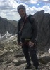
The alarm came at 0430. Oatmeal, tea, hot chocolate, and an apple for breakfast. Left the tent and gear in place. Packed up and was on the trail toward the mine by headlamp at 0530. Orion hung low in the sky over the lights of the valley, often described as looking from a distance like the embers of a dying fire. Hiking by headlamp is interesting. One can only see the trail, the brushy slope immediately to the left, the dark void to the right, and looming above it all the black outline of the peaks blocking out the stars like a hole in the night. Arrived at the mine at 0615, still too dark to see without the lamp, so I rested for a few minutes and let the light come up. This is where the trip goes from hike to something else entirely.

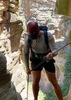
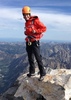
The section up to the saddle was the usual brushy bash. From there I went directly up the first rocks on the right. True, this means you must climb over the false summits, but the down-climbs are short and it keeps you above the brush. Made the Amethyst summit at 0800. There I stopped for the obligatory photos and the first of my four Scotch Whisky tastings. As wine or spirit drinkers will tell you, the impressions made by the beverage are colored by the venue and occasion. We start with the Glenmorangie 10-year old Highland single malt Scotch. Tasting notes: pale gold color, some fruit on the nose, smooth, sweet malt on the palate with hints of peat and very little smoke, followed by a keen awareness of situational reality and rising apprehension.

I was down to the saddle in a jiffy and faced new ground. Worked my way west around the first couple of "divots" (so-called by other HAZers, they are crags), then east around the last one to the base of the ridge rising to the summit of Sister. My notes dictated following the ridge-top as much as possible, but in spite of my inspection from the top of Amethyst that did not look good. It looked better a little bit west of the ridge so I trended over there. In retrospect that was possibly a mistake. It is just cliff after cliff and the need to find a solution with endless false starts and back-tracking. I had promised my wife that I would not do anything crazy and I meant it. Going solo one needs always to have a way out. I continuously asked myself "Have I done anything so far that I can't undo?" As to each move, probably not, but the constant need to divert from the original line left me with the sense that I probably could not find the precise route back to my last known safe position. When you are in a crack or on a ledge you can only see what is in front of you. A solution can be found for the immediate problem but as you go higher you may cliff out and have to go back. After so many starts, dead ends, and re-directs I eventually had to concede that "No, I probably can't undo everything I have done." That is when concern begins to feel like fear. At some point you acknowledge the commitment that has already overtaken you, so up you go. Eventually the cliffs fold over as you approach the summit and suddenly, there you are. Topped out Sister at 0944. I stopped again for the photos and the second tasting. I should have been more pleased since this was my last unclimbed individual peak of the four, but I was too angry with myself for being foolish enough to get up to a spot from which I did not know for certain that I could safely down-climb, and knew from trip reports that the route forward to the 3/2 saddle was risky if not outright dangerous. An unhappy man. For the second whisky we have the Glenfiddich 18-year old Speyside single malt Scotch, aged in fine Oloroso sherry casks. Tasting notes: pale amber color with light peat and chocolate on the nose, smooth, buttery, sugary malt with some acidity and raisins and nuts coming through on the palate, followed by bitter hints of regret and penetrating self doubt.

Swallowing my misgivings I proceeded to the task at hand; getting to the 3/2 saddle. I followed the ridge top, again trending to the west side a bit. More cliffs and back-tracks. More re-directs. Each move individually not too bad, except for a few. On three or four occasions I knew full well that I was taking too much risk, but told myself "If you want to go home today, you have to do this." In most cases the risk is for a fall of a few to maybe ten feet, but the landing would always be on a steep slope of sharp rock and cactus, tumbling another fifty feet down to end upside down, wedged in a crack, spinal injury, fingers all broken from trying to stop, face bashed in. Think "127 Hours". After another hour of this foolishness I was nearing the big southern divot above the 3/2 saddle. My route over and around the divot was probably not too good. There were some sketchy spots there too. Getting down to the saddle was marvelous and my spirits really picked up. I was right on schedule and knew most of the risky stuff was behind me.

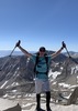
After taking a short break in the 3/2 saddle I dropped down about fifty feet on the east side and worked my way about 300 yards north along the east side of Brother, then up. Here things became really fun. The east side of Brother is a slightly curving series of big slabs starting more vertically lower down with the angle becoming slightly less steep near the top. At the bottom you can spider climb your way up using the plentiful bomb-proof hand and foot holds, and nearer the top where it is slightly less steep you can actually get on a slab and walk up, provided that you have good shoes and don't look down. Not sure I would like to down-climb this, but going up was a blast. Making the summit of Brother was fantastic. Arrived at 1305. I had been there recently and knew the route home. What a load off my mind! More photos and my third whisky tasting. Here we have the Springbank 10-year old Campbeltown non-chill filtered single malt Scotch. Tasting notes: very pale in color, peat, smoke, and fruit on the nose (just the way I like it). On the palate rich, malty, smoky, and chewy with hints of raisins and dates, followed by major notes of relief and a growing sense of well-being and the nearness of accomplishment. This is a good whisky!

Heading north from Brother took me along a fun section of knife-edge. From there I dropped east a bit and found the same exit to the cliff bands that I had used on my prior visit. Two or three more interesting down-climbs later I was on the slab below the saddle. Here I made a route finding error and got down into the brush below Brown's. Wasted a good thirty minutes smashing through the densest brush I have ever seen. Finally got over to the rock and worked up the crack that dumps you out immediately east of Brown's summit, and there, I had it done! Mother Lode! Got there at 1446, for a total time between Amethyst and Brown's of 6 hours 46 minutes. Now for the fourth and final whisky tasting. We have my all-time favorite, the Bowmore 18-year old Islay single malt Scotch. Tasting notes: medium amber in color, fruity, oaky, and peaty on the nose with a hint of smoke. On the palate the smoke comes through with rich, sweet malt, just the right level of peat, ripe pears and sea salt, followed by exultation and deep personal satisfaction. A truly sublime whisky and perfectly suited to the place and occasion.

It was a quick trip down to the camp at Brown's Saddle where I knocked down the tent and loaded the backpack. Having plenty of time I took a leisurely stroll down to the trail-head, arriving with ten minutes to spare before sunset.

I know what some of you are thinking; how could this lunatic drink four different whiskies and do the Mother Lode? I did not drink each whole bottle, just a small mouthful to enjoy the flavors. There, I have left something for the next Mother Lode Tasting Tour. I probably consumed the equivalent alcohol of little more than a single can of beer during the entire trip. Certainly not enough to impair myself. I am not crazy (well, not in that sense anyway). That said, I must recognize myself to be a drinker developing a serious hiking problem. Probably need professional help. I do best when I have a goal to work toward. I am already mourning the accomplishment of my first Lode. Can never do it again for the first time. Can never again experience the Mother Lode with the same level of uncertainty of outcome that both drove and vexed me on this trip. Anybody out there who can help me with this? I'll bring the Scotch.
_____________________
"Aequanimitas."

- Antoninus Pius
 
Nov 15 2014
avatar

 Guides 37
 Routes 564
 Photos 10,923
 Triplogs 1,060

male
 Joined Jan 21 2013
 AZ
Four Peaks Mother LodePhoenix, AZ
Phoenix, AZ
Hiking avatar Nov 15 2014
FOTGTriplogs 1,060
Hiking8.50 Miles 4,060 AEG
Hiking8.50 Miles
4,060 ft AEG
 
Just another Mother Lode, however, this time with company. A really good time, a couple of guys were making first time runs, and Karl was able to finish the hike that he tore his ACL on not quite a year ago I believe.

I did the traditional 1-2-3-4 so it was a different experience for me as well. We did not really rush over the peaks and took some extended breaks at the summits, therefore, it was not as strenuous as my Mother Lode run in June. But I enjoyed this hike nearly as much, I was able to fool around with some new routes and was finally able to see portions of the route that I had missed on my first run.

A little busy on the trail as we neared the trail head, some people camping there as well, most enjoyed a beer and we called it a day. The ride home was interesting to say the least, a little mad max mixed with the old western and a taste of Phoenix.
 Culture
 Culture [ checklist ]
[ checklist ]  Intrepid Back Shot
_____________________
  3 archives
average hiking speed 0.99 mph
1, 2, 3, 4, 5 ... 7  Next

WARNING! Hiking and outdoor related sports can be dangerous. Be responsible and prepare for the trip. Study the area you are entering and plan accordingly. Dress for the current and unexpected weather changes. Take plenty of water. Never go alone. Make an itinerary with your plan(s), route(s), destination(s) and expected return time. Give your itinerary to trusted family and/or friends.

helpcommentissue

end of page marker