username
X
password
register
for free!
help
ArticlesGuidesRoutes
 
Photosets
 
 Comments
triplogs   photosets   labels comments more
Governors Peak - 24 members in 53 triplogs have rated this an average 3.3 ( 1 to 5 best )
1, 2, 3  Next
53 triplogs
login for filter options
Mar 27 2023
avatar

 Guides 110
 Routes 2,246
 Photos 8,982
 Triplogs 2,600

45 female
 Joined Dec 24 2007
 Ahwatukee, AZ
Governors PeakPhoenix, AZ
Phoenix, AZ
Hiking avatar Mar 27 2023
LindaAnnTriplogs 2,600
Hiking5.84 Miles 1,826 AEG
Hiking5.84 Miles   3 Hrs   38 Mns   1.74 mph
1,826 ft AEG      17 Mns Break
 
Linked   none no linked trail guides
Partners partners
gummo
Route Scout Route Recorded  on Route Scout | Pop | Map | Popup | MapDEX
Scott and I got started a little before 0900 and first had to jump across the flowing creek. Not too bad. Then headed uphill. Trail is in okay shape, although a lot of fresh vegetation, which will die off as it gets hot. Nothing scratchy. Well defined all the way to the summit, where we took a quick break. Nice hike back down, although it was warm by my standards. Good to see Scott again!
_____________________
Stop crying and just go do the hike.
 
Jan 21 2023
avatar

 Guides 5
 Routes 27
 Photos 189
 Triplogs 26

70 male
 Joined Dec 06 2002
 Phoenix, AZ
Governors PeakPhoenix, AZ
Phoenix, AZ
Hiking avatar Jan 21 2023
MoovyoazTriplogs 26
Hiking6.10 Miles 1,900 AEG
Hiking6.10 Miles
1,900 ft AEG
 no routes
1st trip
Linked   none no linked trail guides
Partners none no partners
Cold day to hike Governors Peak with Friends Hiking Club. The trail was in good shape, but the drop into Four Tanks Canyon then up to the peak was a hump.
_____________________
A drunkard's dream if I ever did see one
 
Feb 06 2022
avatar

 Routes 386
 Photos 49
 Triplogs 792

43 female
 Joined Jun 23 2015
 Phoenix, AZ
Governors PeakPhoenix, AZ
Phoenix, AZ
Hiking avatar Feb 06 2022
emilystardustTriplogs 792
Hiking5.76 Miles 1,844 AEG
Hiking5.76 Miles   4 Hrs   42 Mns   1.59 mph
1,844 ft AEG   1 Hour   4 Mns Break
 no routesno photosets
1st trip
Linked   none no linked trail guides
Partners none no partners
_____________________
 
Nov 13 2021
avatar

 Guides 25
 Routes 376
 Photos 5,897
 Triplogs 346

40 male
 Joined Mar 01 2018
 Chandler, AZ
Governors Peak and Peak 2992, AZ 
Governors Peak and Peak 2992, AZ
 
Hiking avatar Nov 13 2021
John10sTriplogs 346
Hiking6.45 Miles 2,027 AEG
Hiking6.45 Miles   4 Hrs   38 Mns   1.71 mph
2,027 ft AEG      52 Mns Break
 
1st trip
Partners partners
TboneKathy
Route Scout Route Recorded  on Route Scout | Pop | Map | Popup | MapDEX
After hiking to Indian Mesa Ruins in the morning, we drove to Hells Canyon Wilderness to hike Governors Peak in the afternoon. Time permitting, I planned to go up to Peak 2992 since it's just a short detour off the route to Governors. We got the last of three spots in the pullout area along Castle Hot Springs Road, and there was a pair of other hikers starting out on the trail just ahead of us.

We crossed the dry bed of Castle Creek and signed in at the white podium on the other side. I didn't notice it at the time, but looking at pictures later, there was a warning printed at the bottom of the sign-in sheet that said: "The trails in Hells Canyon Wilderness are clothing-optional. Do not be offended or alarmed if you encounter nudity on the trail." That's the first warning of that variety that I've ever seen at a trailhead. Regardless, all the hikers we encountered were clothed...I would think the alternative would involve a high risk of a very painful sunburn :).

We weren't paying close attention and accidentally veered left onto Spring Valley Trail briefly before realizing we missed Hermit Trail, so we cut across a wash and got back on course. About a mile in, we heard a loud snort to our left and saw a wild burro nearby. The trail was well-defined and had a lot of cairns throughout, but it became a little fainter as we started the ascent toward Governors Peak.

I'd hoped to take a quick detour over to Peak 2992 since it was so close, and @TboneKathy wanted to take a break on the way up, so I left the trail and headed for the peak. There were only two prior triplogs for Peak 2992, and the routes described in those seemed more difficult than they needed to be. I stayed on the trail until I was only slightly below 2992 elevation-wise and then headed for 2992 just before the trail makes a left turn on the way to Governors Peak. I aimed for a small saddle to the southeast of the 2992, and there were some steep stretches with loose rock, but it was a manageable scramble to the saddle and then an easy climb from there.

Based on the lack of triplogs, it was clear 2992 doesn't get many visitors, so I'd brought an empty plastic jar and some blank sheets of paper and placed a register at the summit, then headed back down to the trail. We were running short on time to beat the sunset, so I hurried up to Governors Peak. The two other hikers who we'd seen near the trailhead were up there, and there was a large summit cairn, a sign, and a "height of light" post at the top. There were two summit register jars stuffed with loose sheets of paper, and I found a blank space to sign on the opposite side of @KingSnake's entry from 2/26/21. I didn't spend too long at the peak, but the views of Lake Pleasant and Castle Hot Springs Resort were very nice.

[ youtube video ]

It was a very pleasant hike out as the shadows got longer in the late afternoon/early evening, and we saw one more wild burro on the way out. The sky had some nice color as we finished off the hike with the sun starting to set. The trail was much more defined and gets more traffic than I'd expected based on the descriptions. I'm not sure why the official guide has this one labeled as off-trail hiking--there was a sign-in podium, arrowed "Trail" signs near the trailhead, and consistent cairns all the way to the peak...but, either way, it was a nice introduction to Hells Canyon Wilderness.
 Fauna
 Fauna [ checklist ]
[ checklist ]  Wild Burro
 Meteorology
 Meteorology [ checklist ]
[ checklist ]  Sunset
 
Feb 25 2021
avatar

 Guides 116
 Routes 337
 Photos 11,399
 Triplogs 894

63 male
 Joined Dec 20 2010
 Sunnyslope, PHX
Governors PeakPhoenix, AZ
Phoenix, AZ
Hiking avatar Feb 25 2021
kingsnakeTriplogs 894
Hiking6.09 Miles 1,854 AEG
Hiking6.09 Miles   3 Hrs   20 Mns   1.83 mph
1,854 ft AEG
 no routes
1st trip
Linked   none no linked trail guides
Partners none no partners
Since Governors Peak is so close to Sunnyslope, I ate breakfast at home, instead of picking up QT. Driving past Lake Pleasant on Castle Hot Springs Road, the only confusion I had was when the road makes a 90° turn to descend to Garfias Wash. (Left goes to Spring Valley.) Garfias Wash had water for hundreds of yards upstream of the bridge, as Lake Pleasant’s water level is currently 30 ft. above “full” ( http://pleasant.lakesonline.com/Level/ ).

Parking at the small pullout just past the cattle gate, I could see the white backcountry sign-in stand across Castle Creek, where Spring Valley Trail begins. But the short bluff down to the creek is steep, so instead I walked 100 yds. north on Castle Hot Springs Rd., down to the creek, before doubling back to the stand.

Currently, the Spring Valley Trail and Hermit Trail (go right) split is marked by three cairns. I spotted some burros who waited for me to take several photos. On my way back, I had forgotten about them, so when they snorted I was quite startled. More so than the gunfire which accompanied my final half mile.

My favorite view of the day was from the second saddle, north across Four Tanks Canyon, towards the Governors Peak ridgeline. More so than the pollution-obscured summit view of Phoenix. Even Lake Pleasant was hazy.

From the bottom of Four Tanks Canyon, the trail — Bell Trail? — follows plentiful cairns up a steep wash between Hill 2992, on the right, and the now visible summit of Governors Peak, on your left. It is 390 ft. in 0.4 miles to the third saddle, with some boulder steps and marble-covered slick rock to be negotiated. (Which I slipped on several times while later descending.) The saddle is marked by a large cairn. A trail begins to descend north, towards the Castle Hot Springs Resort, but you should turn left.

The trail climbs 450 ft. in the final 0.4 miles, first along the yellow cliff band, then most steeply up an easy chute, before crossing a grassy slope towards the hidden Governors Peak summit.

For some reason, the sign marking the Governors Peak summit is facing away from the trail. The summit log was a jumble of loose papers. The oldest I found was from December, 1995. As I was perusing the entries, I was surprised by a young gal approaching the summit. I didn’t want to weird her out, so I ate lunch on the side of the summit opposite Lake Pleasant, while she enjoyed the better view. Or the more polluted one.

Hike Video: https://vimeo.com/517839799
 Fauna
 Fauna [ checklist ]
[ checklist ]  Wild Burro
wildflower observationwildflower observationwildflower observationwildflower observationwildflower observation
Wildflowers Observation Isolated
One ocotillo, one redstem stork's bill, both between the saddle (2800 el) and summit (3200 el).

dry Four Tanks Canyon Dry Dry
No sign of water, or moisture, at the trail crossing.
_____________________
http://prestonm.com : Everyone's enjoyment of the outdoors is different and should be equally honored.
 
Feb 14 2021
avatar

 Guides 110
 Routes 2,246
 Photos 8,982
 Triplogs 2,600

45 female
 Joined Dec 24 2007
 Ahwatukee, AZ
Governors PeakPhoenix, AZ
Phoenix, AZ
Hiking avatar Feb 14 2021
LindaAnnTriplogs 2,600
Hiking6.07 Miles 1,793 AEG
Hiking6.07 Miles   5 Hrs   25 Mns   1.30 mph
1,793 ft AEG      45 Mns Break
 
Linked   none no linked trail guides
Partners partners
realm09
watermelonW
Route Scout Route Recorded  on Route Scout | Pop | Map | Popup | MapDEX
Got started around 0945. The trail is cairned the entire way, but requires some attention in a few vague spots. A little rocky in places, but nothing too bad. Great views in all directions from the top. Saw seven burros and one rattler. I’d hike this one a lot more often if the drive wasn’t quite so far.

dry Four Tanks Canyon Dry Dry
Dry where the trail crosses the creekbed. Did not see any pools above or below.
_____________________
Stop crying and just go do the hike.
 
Mar 29 2020
avatar

 Routes 215
 Photos 1,337
 Triplogs 124

53 male
 Joined May 26 2017
 Phoenix, AZ
Governors PeakPhoenix, AZ
Phoenix, AZ
Hiking avatar Mar 29 2020
Nate_FTriplogs 124
Hiking6.56 Miles 1,986 AEG
Hiking6.56 Miles   4 Hrs   49 Mns   1.56 mph
1,986 ft AEG      37 Mns Break
 
1st trip
Linked   none no linked trail guides
Partners partners
caragruey
Quick hike up Governor's Peak today for some exercise and social distance, loved it!!
Never been here before and I was glad there wasn't many people on this trail. It's beautiful out here and the terrain and flora were spectacular! A little bit warm, but not horrible. The only problem was the crowds of people going to the lake and riding their cycles/OHV's out on the road. Very dusty and noisy as you get closer to the road. This hike would be better on a cooler day during the week. Still, a nice place and a nice day! :)
wildflower observationwildflower observationwildflower observationwildflower observationwildflower observation
Wildflowers Observation Isolated
_____________________
 
Jan 20 2020
avatar

 Guides 94
 Routes 840
 Photos 22,055
 Triplogs 1,993

52 male
 Joined Sep 18 2002
 Tempe, AZ
Ducey Garfias, AZ 
Ducey Garfias, AZ
 
Hiking avatar Jan 20 2020
chumleyTriplogs 1,993
Hiking13.41 Miles 2,430 AEG
Hiking13.41 Miles   6 Hrs   33 Mns   2.22 mph
2,430 ft AEG      30 Mns Break
 no routes
1st trip
Partners partners
BiFrost
John9L
slowandsteady
Tough_Boots
A new peak, and a new wilderness checked off the non-existent list. :y:

I had no idea what we would find as far as water goes. It was dryer to start than I was expecting, but wetter along the way than I had figured. The crown jewel was pretty much perfect. A real treat to visit this one. Clouds and a breeze made this an outstanding day to visit. I'd put it on the list for an annual cool-weather loop.

Made it back to town just before a wheel fell off my truck. That could have happened in a worse place! :sweat:
 Fauna
 Fauna [ checklist ]
[ checklist ]  Gopher Snake
_____________________
I'm not sure what my spirit animal is, but I'm confident it has rabies.
  1 archive
Jan 20 2020
avatar

 Guides 4
 Routes 491
 Photos 10,890
 Triplogs 1,257

55 male
 Joined Nov 20 2012
 Phoenix, AZ
Ducey Garfias, AZ 
Ducey Garfias, AZ
 
Hiking avatar Jan 20 2020
BiFrostTriplogs 1,257
Hiking13.41 Miles 2,430 AEG
Hiking13.41 Miles   6 Hrs   33 Mns   2.22 mph
2,430 ft AEG      30 Mns Break
 no routes
1st trip
Partners partners
chumley
John9L
slowandsteady
Tough_Boots
Chumley put together a nice loop with little bit of everything. A good peak climb and some canyoning with more than expected pools along the way. We hiked Governors Peak first and took a break on top to enjoy the views of the lake and everything else. Then headed off trail down to a side drainage feeding Garfias Wash.

Lost of water in Garfias and we did a side trip up canyon to the more scenic stretches with some pools and cascades. Turning around we headed back downstream to lower Garfias Wash which had water the whole way until we exited. The exit followed good trail back to the start and closed the loop.
_____________________
  1 archive
Jan 12 2020
avatar

 Guides 7
 Routes 72
 Photos 14,456
 Triplogs 627

62 female
 Joined Aug 19 2011
 Scottsdale, AZ
Governors PeakPhoenix, AZ
Phoenix, AZ
Hiking avatar Jan 12 2020
outdoor_loverTriplogs 627
Hiking6.50 Miles 1,930 AEG
Hiking6.50 Miles
1,930 ft AEG
 
1st trip
Linked   linked  
Partners none no partners
I walked out this day to have a meeting with the Governor. I was going to ask about declaring this day a minor, nuisance Holiday. I really wanted to go find the Lost Dutchman, but with my Birthday falling on a Sunday this year, I really didn't want to see the Zoo. Took me just a bit to find another Location and I remembered my New Year's Day Hike last year. First time I had ever Hiked in that area and I felt like it was time to go back and do some more. So the goal became to Go West Old Woman. I picked a Hike that I thought I could currently handle.

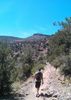
After a Comedy of Errors type morning, I finally got there, a bit later than I wanted, but I was there. Missed the Sunrise, but caught the Moonset. Four steps out of the Vehicle and my right knee starts barking. I've been getting flare ups on it for a couple of months, but usually AFTER a hard workout, not before. Judging from the past, it was going to bother me all day. It was almost like it knew what was coming and was trying to get me to change my mind. I said screw it and started hiking anyway. Along the way, I came to a realization. I really don't have Hiking Legs yet. While the Gym has gotten me in better shape, it's no substitute for a Trail. And this Trail showed little mercy. The baseball sized rocks found every muscle and tissue band in my legs that a Gym never touched. Fatigue was setting in way quicker than I hoped. 30 minutes in, I finally stopped and got some Ibuprofen on board as the barking was getting louder. But I kept going and just took my time. By the time I finally reached the top of the 1st Saddle, and saw what I had left, doubt started to creep in. I was really fatigued and although the barking was reduced to a yap, I wondered if I had enough juice in the legs to make this Peak. But, as some on this Site will tell you, I am stubborn and I hate not finishing something I've started. So I kept going.

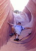
This Hike was beginning to remind me of Bart. But instead of Hills, it was Saddles. I started to wonder if I was ever going to finally meet the Horse. But somehow, I made the last Saddle and then realized that what I had been looking at from down below wasn't even the Peak yet. :sweat: I started to go up the nearest peak, then lost the "Trail" and decided to check RS. Oops. ](*,) As I was on that slant, a Bald Eagle showed up over the Peak I was headed to. And then another and they kept circling. Made me wonder if they had a Nest on that rocky false peak and I was bothering them. But I changed direction, heading for the right Peak, and they disappeared. I scoured those cliffs with the Camera from Governors, but didn't see anything that could be a nest. All of the cliffs around though seemed to be popular perches, judging from all the white on the rocks.

I found the Trail and got back on track. Finally hit the Peak and collapsed for a bit. Enjoyed the views, spied on a Resort and ate lunch. Couldn't sign the Register, it's pretty much a mess, but I squeezed one of my Photography Cards into the jar. A Hummingbird checked me out for a bit while I was up there, hovering as close as 10 feet from my face.

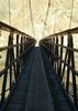
And then it was time to get back down. Took more drugs and hoped the knee held up. It was barking again and made my whole right leg feel weak. Made it down to Four Tanks and took a break. I had thought about making this a Loop and taking Four Tanks down to Castle Creek, but since my knowledge of this area was limited and unsure about the knee, I opted to go back the way I came. Was hoping to get some views of the lake with the sun behind as well.
Ibuprofen and uphill is a knee's best friend. It was down to a whimper going up and over that last saddle. Once I started back down, it progressed back to a yap, but never barked again. I was definitely fatigued, but on an out and back I become like a horse heading for the barn and I manage to finish strong. But when I got to the Escape, I was ready to be at the Escape. :sweat: I have a long way to go to get back in Hiking shape. With that said, I didn't fall on my pumpkin, although this Trip kicked my butt. In spite of the fatigue and the knee, I actually really enjoyed this Hike. With the exception of the road, and some distant gunfire, I had the place to myself and that was really nice. The Scenery was amazing and there were a lot of birds. I heard some Burros, but didn't see any on the Hike. I was very surprised that really, there is a Trail all the way up. It's hard to find in a few places up to that 2nd saddle, but someone has done a good job of Cairn placement, without overdoing it, so it was a pleasant surprise to do very little bushwacking and route finding.

I hit the Escape during the ebbing of the Golden Hour, so although I was done Hiking, I wasn't quite done. Driving out, I ran into some real asses and although the light was poor, I just had to stop and shoot them. I stopped again where the road crossed the water as the light there was still nice. After that, I went into town and had a nice Ribeye and trimmings for dinner. I've survived 57 years and lost a pound of fat on this day, I deserved it. Although my mind would like to be 40, my knees think I'm 65. So I'll have to be content at 57 for now. Cheers!

Way too many Photos...You'd think I would've learned by now. [-(
 Flora
 Flora [ checklist ]
[ checklist ]  Cheeseweed
wildflower observationwildflower observationwildflower observationwildflower observationwildflower observation
Wildflowers Observation Isolated
There are a brave few out there.

dry Castle Creek Dry Dry
At the TH

water 1 out of 5water less than maxwater less than maxwater less than max Four Tanks Canyon Pools to trickle Pools to trickle
Still a few small Pools left where the Trail crosses.
_____________________
Life is not a journey to the grave with the intention of arriving safely in a pretty & well preserved body, but rather to skid in broadside, totally worn out & proclaiming, "Wow What a Ride!"
 
Jan 01 2020
avatar

 Routes 18
 Photos 580
 Triplogs 1,081

42 male
 Joined Nov 16 2010
 Kingman, AZ
Governors PeakPhoenix, AZ
Phoenix, AZ
Hiking avatar Jan 01 2020
nikorock28Triplogs 1,081
Hiking6.00 Miles 1,856 AEG
Hiking6.00 Miles
1,856 ft AEG
 no routesno photosets
1st trip
Linked   none no linked trail guides
Partners partners
LindaAnn
Hiking prior to noon is not really my thing, so I had to make some modifications to my morning food regiment. Linda was using route scout, which was my first exposure to it. I really like the stats and the calculation of aeg, so I will hopefully be trying it out soon. Gradual climb at the beginning, with some dips and through some pools of water. I enjoyed the rocky sections higher up and once the peak was gained, there were very nice 360 degree views, including the intriguing resort beneath. A rescue helicopter passed through and we could see it hovering in the distance, further up canyon. We took a look at Salvation Peak afterwards, which might be doable starting from nearby to the resort. Nice to meet Linda and hike a new trail.
_____________________
  2 archives
Jan 01 2020
avatar

 Guides 110
 Routes 2,246
 Photos 8,982
 Triplogs 2,600

45 female
 Joined Dec 24 2007
 Ahwatukee, AZ
Governors PeakPhoenix, AZ
Phoenix, AZ
Hiking avatar Jan 01 2020
LindaAnnTriplogs 2,600
Hiking6.00 Miles 1,951 AEG
Hiking6.00 Miles   3 Hrs   41 Mns   1.88 mph
1,951 ft AEG      29 Mns Break
 
Linked   none no linked trail guides
Partners partners
nikorock28
Route Scout Route Recorded  on Route Scout | Pop | Map | Popup | MapDEX
Got started a little after 10am. Cool temps and a nice breeze, but it felt warm as soon as we started to go uphill. The trail is fairly easy to follow about 70% of the way, but faint in several places, making a track to follow quite helpful, and cairns abound. Some spots are brushy, and could use some maintenance, but overall not too bad. Great views in all directions most of the way. Excellent views from the top. The hike back down went quickly, and was easier to follow the route. Saw a handful of people on the way down. Nice to meet Nick and hike with him. The road in has been recently graded and is in excellent condition, and should not be a problem for just about any vehicle.
 Named place
 Named place [ checklist ]
[ checklist ]  Castle Hot Springs
_____________________
Stop crying and just go do the hike.
  1 archive
Dec 15 2018
avatar

 Routes 189
 Photos 7,236
 Triplogs 1,740

57 male
 Joined Apr 25 2011
 Goodyear, AZ
Governors PeakPhoenix, AZ
Phoenix, AZ
Hiking avatar Dec 15 2018
NightstalkerTriplogs 1,740
Hiking7.00 Miles 2,014 AEG
Hiking7.00 Miles   5 Hrs   4 Mns   1.93 mph
2,014 ft AEG   1 Hour   26 Mns Break13 LBS Pack
 
Linked   none no linked trail guides
Partners partners
Gallydoll
mt98dew
4th time to Governors Peak and it never disappoints. Had Gallydoll, Jan, Yolanda, Mel, and Linda join me. Trail to 4 tanks canyon is becoming faint at spots. Had an easy time following the cairns up to the saddle. Nice overcast day. Ran into mt98dew on his way back from Salvation Peak. Saw 2 large groups of burros along Castle Hot Springs road on the way in.
wildflower observationwildflower observationwildflower observationwildflower observationwildflower observation
Wildflowers Observation Light
_____________________
 
Oct 21 2018
avatar

 Routes 7
 Photos 273
 Triplogs 234

54 male
 Joined Jul 16 2011
 Phoenix, AZ
Governors PeakPhoenix, AZ
Phoenix, AZ
Hiking avatar Oct 21 2018
EartheistTriplogs 234
Hiking4.39 Miles 925 AEG
Hiking4.39 Miles   2 Hrs   54 Mns   1.85 mph
925 ft AEG      32 Mns Break
 no routesno photosets
1st trip
Linked   none no linked trail guides
Partners partners
The_Dude
_____________________
 
Mar 31 2018
avatar

 Guides 69
 Routes 37
 Photos 3,010
 Triplogs 2,387

55 male
 Joined Oct 24 2010
 Phoenix,Az
Upper Four Tanks CanyonPrescott, AZ
Prescott, AZ
Canyoneering avatar Mar 31 2018
mt98dewTriplogs 2,387
Canyoneering6.75 Miles 400 AEG
Canyoneering6.75 Miles   5 Hrs      1.35 mph
400 ft AEG
Canyon Hiking - Non-technical; no rope; easy scrambling; occasional hand use
A - Dry or little water; shallow or avoidable water; no wet/dry suit
I - Short 1-2 hours
 no routesno photosets
1st trip
Linked   linked  
Partners none no partners
It's funny. I'm doing a hiking log on a a hike I had no intention of doing when I set out this morning. My goal was to hit Governor's Peak and then to find "Salvation", but in my haste to get out the door this morning I forgot my Garmin. I still thought I could find Salvation Peak with the GPS route I had in my head and how some of the pictures displayed Castle Hot Springs (based on Barrett's hike). But I discovered when I reached Govenor's Peak that the two most likely candidates for Salvation Peak made me decide that I did not want to "find Salvation Peak". There seemed to be quite a bit of rugged terrain between Governor's and the two potential peaks with the potential for a lot of loss elevation. I found myself having little desire to attempt that "descent and climb" without having a definitive peak to shoot for. So instead, I headed back down Governor's Peak to the first "ridgeline/shelf" and headed west to the gnarly rock outcropping that had beckoned or me on previous visits. It was a short scramble to the top. Cool! It was relatively easy, but it made me feel daring :) . From there,I continued west to a dry wash that is the upper section to the Four Tanks. From above it looked as if there was a trail heading away from the wash to the south. When I reached the wash, I discovered it was a trail...a game trail. Instead, I turned east/north following the wash in the direction that would reconnect me to Governor's Peak/Hermit Trail. The wash was pretty neat to follow with quite a few dips and falls with pools of water at many of the levels. (Thus explaining the game trail). All were easy to negotiate up until the last one....the 15-20 ft fall described in the other write ups. Neat looking at it from the top down. No water was flowing, but there was water at the bottom. I backtracked a little (maybe 30 feet) to find a good point to climb out of the canyon. Both sides looked doable, but I went with the west side (towards Governor's Peak) because there was less vegetation to deal with. From there it was an easy deal to reconnect to the Hermit Trail and return to the TH. Didn't see a soul while I was out there. But the wildlife did not disappoint. Saw a lone buck, a grouping of four deer near the top of Governor's, a healthy looking squirrel and a rattlesnake (I think). It was curled up for warmth, so I couldn't see the rattles. It was small but good looking. Didn't have my Garmin with me, so my mileage is an estimation based on my other trips to Governor's Peak and the small amount of ground that was covered in the making of this lasso.
_____________________
 
Feb 16 2018
avatar

 Guides 27
 Routes 61
 Photos 2,620
 Triplogs 700

69 male
 Joined Jan 23 2008
 Phoenix, AZ
Governors PeakPhoenix, AZ
Phoenix, AZ
Hiking avatar Feb 16 2018
AZWanderingBearTriplogs 700
Hiking6.10 Miles 1,949 AEG
Hiking6.10 Miles   3 Hrs   18 Mns   2.06 mph
1,949 ft AEG      20 Mns Break
 no routes
1st trip
Linked   none no linked trail guides
Partners partners
AZBeaver
The cool overcast day seemed to cry out for an interesting hike with some decent elevation gain. We parked just off Caste Hot Springs road just after 10.

The trail starts easy enough, slightly uphill and crossing some washes, well marked, decent footing, well defined trail, lots of cairns. Ran into 3 other hikers coming back down about the halfway point. From here it gets interesting -- loose footing, rock scrambles, fainter trail. Had the track on Gaia on my phone and cross checked it fairly often. The trail seems to have two routes as you start up the final wash. One set of cairns keeps you low in the wash with significant scrambling. The high route run parallel on the eastern side and is much more accommodating. We figured that out on the way down.

The recent rains had left a lot of small rock pool of water in the drainages. Life is good in the hills right now.

The saddle at the top of the last wash had a surprise for us. Looking east at the at the edge of the ridge line was a small window. It is in the vicinity of N33° 58.355' W112° 22.078'.

The summit had the great views you'd expect. Seems to be a lot of construction work at historic Castle Hot Springs. Another Arizona destination in the works?

Back at the trailhead we poked around the old ruins at the mouth of the wash before heading back to find a huge garbage burger with all the fixin's.
_____________________
All you have is your fire...
And the place you need to reach
  2 archives
Dec 23 2017
avatar

 Guides 264
 Routes 2,797
 Photos 14,494
 Triplogs 5,894

55 male
 Joined Nov 20 1996
 
Spring Valley - Garfias - Governors Peak Loop, AZ 
Spring Valley - Garfias - Governors Peak Loop, AZ
 
Hiking avatar Dec 23 2017
joebartelsTriplogs 5,894
Hiking11.88 Miles 2,139 AEG
Hiking11.88 Miles   7 Hrs   38 Mns   1.89 mph
2,139 ft AEG   1 Hour   21 Mns Break4 LBS Pack
 
1st trip
Partners partners
The_Eagle
Here's a little loop Bruce wrote six years ago. That one ended on a sour note with a private property scolding. We hiked a bonafide legal version with Ben four years ago. This nearby gem felt like a good fit for a tight holiday schedule. If you enjoy moderately challenging off trail adventures & live near the Valley you might enjoy exploring.

Spring Valley Trail
The morning light through this desert jungle never disappoints. Per usual I asked myself why I've neglected more visits.

Garfias Wash
Under 3 miles in take a right off trail into Garfias. If it rubs you the wrong way turn back pdq because 5 miles of sand and gravel is looking to scold your feet. 6 miles in on a short out-n-back towards Horse Creek we found slow running water and a good twenty foot diameter pool capped with half inch thick ice. The first two hours of our hike were cold and it's been cold recently in the valley... still seemed unexpected.

I took a break at the pool while Bruce scrambled up creek. Autumn auditioned technicolor magic on a willow and cottonwood. Along with a trickling creek and the warmth of the sun after a chilly start was a real treat.

Unnamed Creek
Not sure if this one is named. We take it NW out of Garfias to the SW side of Governors Peak. There are 2 areas to scramble. No biggie for most. It was just in my range with lots of help from Bruce. I get by fine and adapt on most things one handed. Crumbly rock scrambles without corrective-balance race nightmares through the mind at warp speed.

Governors Peak
The western approach is semi steep and semi loose. Nothing horrible, going up is less prone to accidents and a trail gets you down the South. We lunched with a curious bee Bruce dubbed George. Excellent internet kept lunch social.

Synopis
Great little adventure-hike near the valley with exotic terrain, a smorgasbord of cacti and a hint of water.

Consumed 38 oz water
foliage observationfoliage observationfoliage observationfoliage observationfoliage observation
Autumn Foliage Observation Moderate
2 days to Christmas, Autumn keeps on giving. Cottonwoods, Willows & Tamarisk looking nice
_____________________
- joe
 
Dec 23 2017
avatar

 Guides 41
 Routes 1,626
 Photos 14,983
 Triplogs 2,760

69 male
 Joined Jan 20 2009
 Far NE Phoenix,
Spring Valley - Garfias - Governors Peak Loop, AZ 
Spring Valley - Garfias - Governors Peak Loop, AZ
 
Hiking avatar Dec 23 2017
The_EagleTriplogs 2,760
Hiking12.97 Miles 2,278 AEG
Hiking12.97 Miles   7 Hrs   33 Mns   1.94 mph
2,278 ft AEG      51 Mns Break13 LBS Pack
 
1st trip
Partners partners
joebartels
Pre dawn start with temps in the 30's and dead batteries in the head lamp. The cell phone sufficed for the first 20 minutes until daylight.

We warmed up with the uphill on the Spring Valley Trail with the sun rising. This is a real nice trail to take with the sun rising over Lake Pleasant.

Dropping into Garfias Wash, we seemed to loose about 10 degrees of temperature. This is an easy wash walk with interesting geology. Some may not like the need to empty the sand out of your shoes occasionally (like BoeJartels)

We got to an area that we practiced Safety First and Joe waited, while I scoped out a bit farther towards Hell Canyon.

Back to pick up Joe and headed up the unnamed side canyon we'd been in a few times before. I remembered there being one area of concern for our Safety First campaign. Slow and steady and we made our way up the 12' dry fall. Oops, forgot about the second one. The best we could do on this one, was safety second. With a bit of time and patience, 20'er negotiated.

The climb to Governors Peak from our angle was steep but straightforward. Great views for lunch. First lunch I can remember where we could see the end of the hike and truck, some 3 miles away.

Governors Peak 360
[ youtube video ]

Great day in Hell.

No Burros sighted, we were brayed twice.

foliage observationfoliage observationfoliage observationfoliage observationfoliage observation
Autumn Foliage Observation Isolated

water 1 out of 5water 2 out of 5water less than maxwater less than max Horse Creek Light flow Light flow
Did not make it to the spring, but there was plenty of filterable water flowing downstream
_____________________
There is a very fine line between "hobby" and "mental illness."
Dave Barry 🦅
 
Mar 29 2017
avatar

 Triplogs 1

75 male
 Joined Feb 15 2017
 peoria
Governors PeakPhoenix, AZ
Phoenix, AZ
Hiking avatar Mar 29 2017
BigDipperHikerTriplogs 1
Hiking6.10 Miles 1,900 AEG
Hiking6.10 Miles
1,900 ft AEG
 no routesno photosets
1st trip
Linked   none no linked trail guides
Partners none no partners
I appreciate the input on this hike from others. I and five of my hiking friends did this hike on 3/29. The trail is very over-grown what with all of the winter rains. The Brittle Bush and wildflowers are spectacular. This trail was really challenging to say the least. As documented by others the first part, up to the second saddle, is fairly easy to follow what with all of the large cairns. After that its a crap shoot especially now with the heavy growth to find a track to the top. Thanks to another poster's GPS route we found a route to the top. Coming down was a real challenge. The loose rock caused several of us to fall and sustain a few cuts and scrapes but nothing serious other than our pride. I think this trail would be easier to navigate in the winter when its cooler and less covered in vegetation. A great hike but we all were tired after the steep climb and trek back.
wildflower observationwildflower observationwildflower observationwildflower observationwildflower observation
Wildflowers Observation Substantial
Some of the best wildflowers I have ever seen in the desert
_____________________
 
Jan 29 2017
avatar

 Photos 326
 Triplogs 124

71 female
 Joined Jan 04 2014
 Phoenix, AZ
Governors PeakPhoenix, AZ
Phoenix, AZ
Hiking avatar Jan 29 2017
AZBeaverTriplogs 124
Hiking6.20 Miles 1,900 AEG
Hiking6.20 Miles   5 Hrs   25 Mns   1.14 mph
1,900 ft AEG15 LBS Pack
 no routes
1st trip
Linked   none no linked trail guides
Partners partners
tibber
trekkin_gecko
Hiking Governor's Peak near Castle Hot Springs today with Angela Romain (Tibber) and Kelly Hiatt (Trekkin Gecko) and my neighbor Stephanie Balt (Mrs. Balt) .....she really needs to change her hiking name but that's another story. What a fantastic day! The weather was absolutely perfect. Sunny, no wind, warm and beautiful. I always love going out to the Lake Pleasant area as the views in every direction are stunning. There's a confusing area where the trail splits (take the right side) with large cairns on the left and the right and in the middle. People love building cairns in this area all the way up until about the last mile. That's where you really need your trail scouting skills. Hiking this trail seemed easy at first although you are quickly heading up and then down one saddle to climb up another. Once you caught your breath and stopped at a flat spot, you take in the views--360 degrees of them. The desert looked more like a golf course. Grass growing everywhere thanks to the rain we've been getting lately. Once you reach the peak, you look down on the Castle Hot Springs resort. I hope the new owners build this place back to it's beautiful original status and open it up to the public. Lots of history there. I totally enjoyed my day with some great gals.
 Flora
 Flora [ checklist ]
[ checklist ]  Cheatgrass

water 1 out of 5water 2 out of 5water less than maxwater less than max Four Tanks Canyon Light flow Light flow
Still a little water flowing in Four Tanks Canyon.
_____________________
 
average hiking speed 1.76 mph
1, 2, 3  Next

WARNING! Hiking and outdoor related sports can be dangerous. Be responsible and prepare for the trip. Study the area you are entering and plan accordingly. Dress for the current and unexpected weather changes. Take plenty of water. Never go alone. Make an itinerary with your plan(s), route(s), destination(s) and expected return time. Give your itinerary to trusted family and/or friends.

helpcommentissue

end of page marker