|
| | | Goldfield Hi Country Arches Loop, AZ | | | |
|
|
Goldfield Hi Country Arches Loop, AZ
| | |
| |
|
| Hiking | 12.01 Miles |
2,183 AEG |
| | Hiking | 12.01 Miles | 9 Hrs 24 Mns | | 1.76 mph |
| 2,183 ft AEG | 2 Hrs 34 Mns Break | | | |
|
|
| |
| Partners |
|
[ show ]
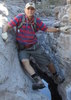
| partners | | We'd had this one on our list for a while and wanted to fit it in before the bald eagle closures start on December 1. We started from the Blue Point Trailhead at the north gate to Bulldog Canyon, and we had our first wildlife sighting on the drive to the trailhead as a coyote ran alongside the highway. The temperature was in the upper 30s when we set out on the OHV roads, and our goal for the day was to visit the three named arches in the area (Delicate, Precarious, and Sunrise).
We started out generally following @adilling's route from ~ five years ago that forms a counter-clockwise loop with a few spurs out to some overlooks. We were fairly warned--his triplog said, "If you ever follow my gps for this hike, you will be cursing me, as I took a torturous route to get to the Gateway Canyon trail." I was mostly cursing myself for not picking a better route for the early part of the hike  . Once we left the roads, we had a very slow mile covering loose, steep hillsides, with a lot of ups and downs across small but steep drainages. The highlight of that mile was surprising and scattering a group of 5+ javelinas in one of those drainages. . Once we left the roads, we had a very slow mile covering loose, steep hillsides, with a lot of ups and downs across small but steep drainages. The highlight of that mile was surprising and scattering a group of 5+ javelinas in one of those drainages.
We made our way up a steep, crumbly embankment to leave another creek bed, and while I waited at the top, I stepped toward some low brush and heard a rattle. I'd been standing there for a few minutes without realizing there was a well-camouflaged rattlesnake coiled in the brush, and that final step was close enough to earn a warning rattle...quite the day for wildlife.
We finally connected with the well-cairned trail that led us through Gateway Canyon up to the saddle. It's a beautiful area full of caves and recessions in the cliffs. We considered taking a detour up to Peak 3097 but decided against it, not knowing what the terrain was like on the remainder of the loop, so we continued to Delicate Arch, a long, thin arch that looks like it's barely hanging on.
From there, we continued toward Precarious Arch, and I detoured over to an overlook for some views of Saguaro Lake and the Salt River before we reached the second arch. That was another small but nice one, formed by a boulder lodged (precariously) between two other rocks. Then we headed northeast, and I went up to the Bulldog Cliffs High Point--more great views, and there was a summit register at the top, placed in 2021, with the most recent entry from earlier this month.
[ youtube video ]
Next up was the descent down the chute toward Sunrise Arch. The top was straightforward and not too steep, but it got more exciting farther down. I briefly thought we'd cliffed out at one point, but we moved over to the east wall of the canyon and found a safe route down. It looked a little intimidating from above, but the drops were manageable, and the rock was solid, unlike so much of the crumbly stuff we'd been on most of the day.
[ youtube video ]
I hadn't looked at pictures of Sunrise Arch in advance, and I was pleasantly surprised at how large it is. It's big enough to walk out on top, and we enjoyed the views from above and below...that whole part of the canyon around the chute and the arch is very nice.
[ youtube video ]
We hiked down through the arch, following a bunch of informal cairned trails until we were near the river again and followed that west. A Maricopa County Sheriff helicopter with an officer's legs hanging out the side circled overhead a few times. Not sure if that was a rescue operation, a search for an escaped convict, or just a training flight...
Overall, it was a nice day in a new part of the Goldfields for us...a few nice wildlife sightings, great scenery, and perfect weather. I didn't see anyone all day, though TboneKathy saw two people going up to the Bulldog Cliffs High Point while I was coming down...not sure how I passed without seeing them. I was happy the timing worked to fit this in before the closure, and it's an area I'd gladly visit again. Next time I'll take a more efficient route over to Gateway Canyon and use the extra time to check out Peak 3097 . |
| | |
|
|
|
 Route Editor


 We did the long version to get the miles. We saw quite a few ducks and did a lot of sand walking on the way to our turn off. It was a nice little climb up to the arch and was pretty cool. The hike goes right through the arch. from there it was up to the Sky Island and on to do a little exploring. The views were great from up top. On the way back we saw the Delicate Arch before hitting the saddle and heading down the chute. We saw an Eagle along with few other birds and a few different flowers. It was a little warm on the way back and the sand walking wore me down


 This was not a trail to do without a GPS, there are so many trails meandering through this area that you can easily get off and not know it.
 ](https://hikearizona.com/dex2/images/smilies/eusa_wall.gif "Brick wall") I would like to have just been able to chalk this all up to karma but I'm a Christ-follower and don't believe in that karma stuff, SOOOOOO that means I can only chalk all this up to stupidity.
I would like to have just been able to chalk this all up to karma but I'm a Christ-follower and don't believe in that karma stuff, SOOOOOO that means I can only chalk all this up to stupidity. 
 So, all in all, I paid $20 in batteries (which I didn't end up needing) and $10 for a pass to basically hike up Pass Mountain. Expensive hike.