|
| | | |
| |
|
| Scenic Drive | 8.00 Miles |
800 AEG |
| | Scenic Drive | 8.00 Miles | | | |
| 800 ft AEG | | | | |
|
|
| |
| Linked |
|
none
[ show ]
| no linked trail guides |
| Partners |
|
none
[ show ]
| no partners | | I've been wanting to get out and get some local Autumn color but so far, no luck. I had some good luck a couple of years ago out along Lower Fish Creek so I thought I would give it a try and if the colors weren't there, I could continue North along the Apache Trail looking further.
It was chilly and windy once I got through Tortilla Flats and up into the high country so I was glad I had the foresight to wear a down vest to ward off the elements. I pulled over at the Fish Creek Hill viewing lot and CRAP  Not only were the trees still fresh and green, there was no water in the creek.... Bummer! I continued on down the long scenic (and deserted) hill, stopping along the way to take some photos of the pre-sunrise and the, still dark, Fish Creek Canyon. Not only were the trees still fresh and green, there was no water in the creek.... Bummer! I continued on down the long scenic (and deserted) hill, stopping along the way to take some photos of the pre-sunrise and the, still dark, Fish Creek Canyon.
At the bridge, I again stopped and got out to view the canyon and take a couple of photos but it was too dark to get anything presentable and.... no water, not even pools below the bridge. I pulled off at the curve and hiked the dry creek bed up and down and, although the trees are still green, they're on the verge of turning. It's protected down there and the wind hasn't stripped the leaves from the trees so it might be good later on.
It was still early and the sun was breaking above the high cliffs so I headed North again. The trees along the Lewis and Pranty Creek are still green and turning slightly giving off a nice glow to the drive along the wash. Then I was driving alongside a calm Apache Lake with the occasional fishing boat and.... no colors. At long last along a seemingly endless washboard road, I reached the Roosevelt Dam, but it too was not very photogenic with low water levels exposing the dark gray rocks below the dam's powerhouse.
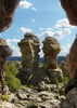
Because I was in the neighborhood, I wanted to stop in at the Tonto National Monument and view the ruins for the first time. I just missed the tour to the upper ruins so I had to be content to visit the lower ruins. After the rough drive up here, it was pleasurable to get out and hike the steep, but paved, path leading up to the alcove where the ruins are located. It was only me and a young tour guide up there, so I got the "special" tour, without interruptions.
The ruins are high along the upper cliffs providing some outstanding views of the lake and the Sierra Ancha Mountains on the other side, I was even able to spot the "Angle Wings" tailings from the Asbestos mines high on the distance ridge. Glad I got the opportunity to view the ruins without the hoards of tourists cluttering up the views.
Now it was getting to the time to decide whether to head back the long way, by way of Globe, or take the slow, rough, but scenic and shorter, Apache Trail. Scenic and shorter won hands down  I stopped again at the Fish Creek Scenic Overlook and had a lunch snack and hiked to some of the higher overlooks on the other side of the road... a short walk that was well worth the views. Maybe another week to 10 days and I'll try it again. I stopped again at the Fish Creek Scenic Overlook and had a lunch snack and hiked to some of the higher overlooks on the other side of the road... a short walk that was well worth the views. Maybe another week to 10 days and I'll try it again.
 |
|
Autumn Foliage Observation Light
The Cottonwood, Willow and Sycamore trees are only now at the verge of turning, needing another week or two to become colorful. |
|
| _____________________
| On every trip into the Superstitions, I find another Gold Mine. Today the mine was filled with Memories. I can not wait for the next trip. |
| | |
|
|
|
 Route Editor