username
X
password
register
for free!
help
ArticlesGuidesRoutes
 
Photosets
 
 Comments
triplogs   photosets   labels comments more
Sabino Box below Box Springs Trail - 2 members in 16 triplogs have rated this an average 4 ( 1 to 5 best )
16 triplogs
login for filter options
Nov 13 2016
avatar

 Guides 3
 Routes 569
 Photos 11,976
 Triplogs 1,634

50 female
 Joined Sep 18 2009
 Tucson, AZ
Sabino Box below Box Springs TrailTucson, AZ
Tucson, AZ
Hiking avatar Nov 13 2016
GrottoGirlTriplogs 1,634
Hiking6.08 Miles 1,781 AEG
Hiking6.08 Miles   6 Hrs   31 Mns   1.12 mph
1,781 ft AEG   1 Hour   4 Mns Break
 
Linked   none no linked trail guides
Partners partners
gloope
Fun time exploring Sabino Box and up canyon with fri nds. The route we took se md sportier than I remembered. We found a route out of the canyon that took us past the Raycreation climbing area. Wonderful day!
_____________________
 
Jun 18 2016
avatar

 Guides 3
 Routes 569
 Photos 11,976
 Triplogs 1,634

50 female
 Joined Sep 18 2009
 Tucson, AZ
Sabino Box and More, AZ 
Sabino Box and More, AZ
 
Hiking avatar Jun 18 2016
GrottoGirlTriplogs 1,634
Hiking7.41 Miles 2,416 AEG
Hiking7.41 Miles   7 Hrs   35 Mns   1.42 mph
2,416 ft AEG   2 Hrs   21 Mns Break
 
1st trip
Linked   linked  
Partners partners
Baja Arizona Hiking
gs31416
I was a little disappointed that the fire didn't even come close to getting rid of all the poison ivy. But not having to climb over big logs was nice! Checked out the Box. Just enough water to make it nice a cool! Then continued on downstream for a way. Bushwhacked up to the ridgeline. After a while we decided to contour over to the Box Camp trail for something new. Saw a cool rock formation that I'll have to go back to checkout. Fun day!
_____________________
 
Jul 12 2015
avatar

 Guides 3
 Routes 569
 Photos 11,976
 Triplogs 1,634

50 female
 Joined Sep 18 2009
 Tucson, AZ
Aspen Sabino Loop, AZ 
Aspen Sabino Loop, AZ
 
Hiking avatar Jul 12 2015
GrottoGirlTriplogs 1,634
Hiking8.38 Miles 2,544 AEG
Hiking8.38 Miles   7 Hrs   44 Mns   1.60 mph
2,544 ft AEG   2 Hrs   29 Mns Break15 LBS Pack
 
1st trip
Partners partners
Pivo
RedwallNHops
We did a loop which included an off trail section that I found described in the Cowgill book. There used to be a trail that connected the Aspen trail to the Box Springs trail but nearly all traces of said trail likely burned. I believe this trail probably existed at the same time as the Box Camp and was the way to access Mt Lemmon. As the book described the majority of the off trail we navigated was a jungle! We encountered scrub oak, locust, buckthorn, and grape vines. There was also a lot of downfall and slick granite rocks. All of which made our progress quite slow. One of the members of our party had some trouble with the bushwhacking, I hadn't realized that he had never bushwhacked before else I would have recommended something easier in the area like Brinkley Point.

Our goal for the day was Sabino Box and a swim. We were surprised at how low the water levels were at the Box. Normally, we find running water and instead the water was just trickling. In order to get out of the pools webbing was required. I made a handline with a foot loop which enabled those who swam a way out - next time I will take the time to build an etrier to make it really easy.

We hung out at Sabino box for a while before we took on the Poison Ivy patch known as the Box Springs trail. At the saddle, strange antics were seen as Carole rolled in the dirt and pine needles and Joel rubbed himself like a bear on the trees. Both of them trying to eliminate any poison ivy oils that may have transferred to their clothes.

On the hike out, we got a few sprinkles from a storm that rolled in. It was a nice, cool walk out!
_____________________
  1 archive
Jul 13 2013
avatar

 Guides 3
 Routes 569
 Photos 11,976
 Triplogs 1,634

50 female
 Joined Sep 18 2009
 Tucson, AZ
Sabino Box and Brinkley Point, AZ 
Sabino Box and Brinkley Point, AZ
 
Hiking avatar Jul 13 2013
GrottoGirlTriplogs 1,634
Hiking8.03 Miles 2,998 AEG
Hiking8.03 Miles   8 Hrs   26 Mns   1.63 mph
2,998 ft AEG   3 Hrs   31 Mns Break
 
1st trip
Partners partners
Baja Arizona Hiking
RedwallNHops
After having an awesome vacation it seemed like nearly anything I could plan would be a major let down so I had to get a bit creative. I like Sabino Box, but on it's own it's too short. I also like Brinkley Point but again on it's own it's too short. We've already explored from the Box to Aspen trail and from the Box to Sunset Trail so this time we had to go down canyon then go up to Brinkley. And as usual, people signed up for the crazy Alt Hike...

We started out on the Box Camp trail and then went down the Box Spring trail. After the cut off for Brinkley point the trail can be hard to follow. We were constantly climbing over things on the steep, steep hillside. Then the fun began, the POISON IVY was lush and it was EVERYWHERE as we approached the creek!

We go into Sabino and headed straight for the Box before having a break. The box is a beautiful area. Gary and I went to check things out. It was definitely higher than last year and the water was running a bit faster. But everything looked good to go. Gary rigged some hand lines so that when people plunged into the narrow spot under the waterfall they could maneuver without problems. It was especially good because none of us could touch bottom. It was fun watching peoples faces as they realized they couldn't touch and that the water was kind of cold!

We continued rock hopping downstream. It was fun because if we needed we could just slide into the water since we were already soaked. The views were awesome! It's so nice to be in an area you haven't explored yet!

We came across a pool that looked great for jumping in so we had our tall guy, Mike, go in and see if he could touch. Since he couldn't we tossed our packs in and jumped! What a rush! Then we convinced Gary to jump. So he throw his pack in and then kind of jumped/slid down. While watching I realized that he was sinking. I swam over and gave him a boost and then suddenly found myself plunging underwater. We continued this cycle a few times. I was actually kind of concerned that we'd drown. But finally I was able to get him closer to where we could touch. Plus someone sent out a pack that Gary could grab. Note to self, don't leave home without the pool float!

No long after that we had a few downclimbs that were not great for short people (myself included). Therefore we utilized Mike again but this time as a ladder. In one spot it didn't work so well as he had his hands out to catch Andrea and his thumb somehow was inserted into her eye socket. I guess it was a strange and uncomfortable (painful for Andrea) for both of them. Luckily no damage was done!

Shortly after that I attempted to sprain my ankle. With all three incident happening pretty closely together it was kind of stressful for me. At some point I noticed that I had lost some of my vision (migraine was coming on).

Not long after that Joel was climbing up and around a bunch of pools with dropoffs and his hiking pole fell down into the creek and sank. Joel, Gary, and I looked for it for a bit and finally found it. After that I called for a break so I could find some drugs.

Just a few minutes into our break it started to rain. Big drops came down. We had a quick discussion and decided that instead of continuing down the .3 miles to where I wanted to go up to Brinkley that we would go up a near by drainage. Since the water level was already somewhat high it seemed to be a good idea to be out of the canyon during heavy rain. So up we went. The drainage went straight up but was fairly clear of brush and for the most part easy to navigate. We continued up scrambling. At some point Mike claim the award for first to bleed. We ended up in some brush and we pushed through the pokey stuff. At some I stabbed my hand in an agave and started to drip, bummer if it had only been a few minutes earlier...

We keep climbing until finally we hit the ridge that goes to Brinkley. I wasn't up to just going back to the cars so in the pouring rain we continued on to Brinkley. It was thundering some so I was glad we had some tree cover.

The rain lightened some when we got to Brinkley. So we got to scramble up and check out the view. But we didn't hang out too long because of the weather. We turned around to head back to the cars.

At some point on the ridge line the rain stopped. We climbed up and up the ridge back to the trail.

On the trail we ran into a few people which was surprising considering the weather. We hit the car just after 4 PM.

We all agreed that it was a great, nice, long day hike! I was glad that all ended well!
_____________________
 
Jul 13 2013
avatar

 Guides 1
 Routes 269
 Photos 613
 Triplogs 1,360

50 male
 Joined Dec 22 2003
 Tucson, AZ
Sabino Box and Brinkley Point, AZ 
Sabino Box and Brinkley Point, AZ
 
Hiking avatar Jul 13 2013
RedwallNHopsTriplogs 1,360
Hiking8.03 Miles 2,998 AEG
Hiking8.03 Miles   8 Hrs   26 Mns   1.63 mph
2,998 ft AEG   3 Hrs   31 Mns Break
 no routesno photosets
1st trip
Partners partners
Baja Arizona Hiking
GrottoGirl
perfect day of exploring
_____________________
 
Sep 08 2012
avatar

 Guides 3
 Routes 569
 Photos 11,976
 Triplogs 1,634

50 female
 Joined Sep 18 2009
 Tucson, AZ
Sabino Box below Box Springs TrailTucson, AZ
Tucson, AZ
Hiking avatar Sep 08 2012
GrottoGirlTriplogs 1,634
Hiking6.00 Miles 1,726 AEG
Hiking6.00 Miles   6 Hrs   26 Mns   1.79 mph
1,726 ft AEG   3 Hrs   5 Mns Break20 LBS Pack
 
Linked   none no linked trail guides
Partners partners
Baja Arizona Hiking
RedwallNHops
After having a wonderful vacation it's hard to go back to standard hiking. Therefore a canyon trip was needed. I scheduled Sabino Box and an up canyon explore on Alt meetup and it filled up quickly, even with all my warnings:

"Do you love Poison Ivy? Do you love being scratched up and bloody? Do you love the potential to tumble down a steep slope? If so, please join me on this awesome adventure. The faint of heart need not apply"

I guess there are a bunch of crazies in the Alt group :) Everything I promised was delivered.

The morning started out with the threat of rain. The mountain was socked in but we decided to go on anyway. I kept in mind that if it did rain we may have to bail and return the way we came instead of exploring upper Sabino.

The trip down Box Spring "Trail" was full of poison ivy and extremely steep. We also were able to access the Box this time. Gary brought some webbing and it allowed us to safely drop into the water without having to worry about the rushing waterfall right next to us. We managed to get Joel to come in with us. It was fun to check the whole box out instead of just looking at it longingly.

On the way out of the box I encountered some issues, I couldn't hold myself up while half in the cold water and swing one of my legs (with the extra water weight in my Gortex boots) over the lip into the "cave". We ended up having Gary go first and I gave him a bit of a butt boost which is difficult when you can't touch ground. Then we kind of climbed up Gary.

Then we headed up Sabino Canyon. We rock hopped, scrambled, hiked up steep banks, until we reached the Sunset Trail. Then we made our way on the routes in Bear Wallow to the cars.

Awesome day, awesome people. It's nice to have a group of people all capable and willing!
_____________________
 
Sep 08 2012
avatar

 Guides 1
 Routes 269
 Photos 613
 Triplogs 1,360

50 male
 Joined Dec 22 2003
 Tucson, AZ
Sabino Box below Box Springs TrailTucson, AZ
Tucson, AZ
Hiking avatar Sep 08 2012
RedwallNHopsTriplogs 1,360
Hiking6.00 Miles 1,726 AEG
Hiking6.00 Miles   6 Hrs   26 Mns   1.79 mph
1,726 ft AEG   3 Hrs   5 Mns Break
 no routesno photosets
Linked   none no linked trail guides
Partners partners
Baja Arizona Hiking
GrottoGirl
_____________________
 
Jul 15 2012
avatar

 Guides 3
 Routes 569
 Photos 11,976
 Triplogs 1,634

50 female
 Joined Sep 18 2009
 Tucson, AZ
Sabino Box below Box Springs TrailTucson, AZ
Tucson, AZ
Hiking avatar Jul 15 2012
GrottoGirlTriplogs 1,634
Hiking7.50 Miles 2,542 AEG
Hiking7.50 Miles   8 Hrs   16 Mns   1.78 mph
2,542 ft AEG   4 Hrs   3 Mns Break20 LBS Pack
 
Partners partners
Pivo
RedwallNHops
After yesterday's massively fun adventure, I started out the day pretty skeptical. I was thinking that something was going to spoil the day. First off, I had posted this hike on Alt Meetup and had a few people sign up (I drafted Joel and Mark - it was too late Friday night to actually ask them if they wanted to go so I made an executive decision). One of the people who signed up for the hike had no history with the group, which made me nervous.

We got to Le Buzz and I got my normal pastry and espresso (I think I have an issue). Then we found our newbie. Shorts and a bag that looked like it belonged on a beach not a hike. I introduced myself to her and told her what I knew the hike to entail: 8 miles which included off trail hiking, steep, and poison ivy. I asked her how much water she had and she dug out of the bag a smallish bottle. I told her that at least 3 liters were required (stated in the description of the meetup). She then took off to Walgreens to buy a backpack and water. She came back a few minutes later with a backpack, water, and a cute floppy straw hat. She loaded up the backpack with her food and other items. Then we were off.

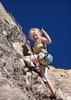
The entire way up the mountain I was nervous. She was riding with someone else so I didn't get to hear her history. Just the fact that she wasn't totally prepared seemed to be enough for me. I was cursing the fact that we were going to go downhill first so we'd be about a third of the way through the hike before I could see how she handled elevation gain.

Anyway, on the way down Box Camp Trail we cruised. We turned at the unsigned junction with Spring trail. At the saddle we ran into a couple with a Great Pyrenees. What a beautiful dog! He was sporting a fresh haircut and a shaggy tail. They asked about the area and we told them what we knew about Brinkley Point and also about our plan to go see Sabino Box and then hike up to the Aspen trail. Luckily, they had the old Rainbow Editions map so they didn't think we were too crazy. In fact they ended up following us down to Sabino.

From the saddle the route is hard going. It's practically straight down a drainage with a lot of downfall, loose dirt, rocks, and POISON IVY! We saw more poison ivy than I've ever seen in the Catalinas. There were spots where you really couldn't avoid it.

After a bit we made it to Sabino Creek. It was beautiful! There was a lot of water and it made a nice early lunch spot. We checked out the old sign and then made our way to the Box.

The Box was incredible. The water had moved in some large boulders and also cut paths through granite to make stunning curves. We found ourselves on a huge boulder that was slanted so you could get a good look down. After sitting there for a few minutes I couldn't take it. I had to see more. Other triplogs had mentioned a cave but I was thinking it might be underwater since I hadn't seen anything like that. I moved to the side of the big boulder and noticed that there were old cuts in the rock and it looked like if I went down I'd probably be able to make it back up. So, down I went. From there, I looked around and finally found the cave. Basically, it is some rocks holding the huge slab boulder that we were sitting up on up enough for you to crawl under. From here you can access the box and in the event you don't want to swim, you can still get good pictures. The rushing of the water into the Box made me leery of swimming so I abstained. Maybe next time...

After our long break at Sabino Creek we headed up to the Aspen trail. This time we had no start of a route to follow, so we just found the drainage the the old trail supposedly went up. The Cowgill Eber Catalina's book had mentioned that in years past before the road people used an old trail to get to the top. We didn't see any evidence of the trail - but we didn't look to hard. We just went where there was the least amount of buckthorn and went uphill. We were a ridge next to the drainage which worked pretty good.

We kept looking back and the view was amazing. You could see Brinkley Point, Rattlesnake Peak and much more. We also could see our progression based on the saddle before the death march down to Sabino Creek.

At one point we found a spot where we had to make several major choices. We saw a crack that went up a way and we decided to take it. From there we had a choice. One guy scoped up ahead following the contour of the drainage, while the rest of us looked up. We decided to go up because our newbie had a bit of an issue with the exposure in the crack and to contour we would encounter a bit more. Things looked clear above the huge rock that was most of the hillside so we proceeded. The other guy chose to go his route (he has mucho experience and had a radio so we didn't mind splitting up).

After we got above the big rock we found a fabulous view spot and some cairns! We wondered if maybe climbers accessed the area but we didn't see any bolts. Plus it was a long way from the Marshal Gulch parking area. We checked in on the radio and heard that the other guy was having some issues and having to back track. We decided to just meet on the Aspen trail.

We followed the cairns up to a ridge and then made our way along the ridge until it plunged down a bit to a saddle. From the saddle my GPS told us we were only 400 feet away from the Aspen trail.

When we got to the Aspen trail we were so happy. We practically collapsed from the energy that was spent climbing up to that point from Sabino. I looked at my GPS and it said we had only gone 4 miles total! Are you kidding me???? It felt like we had gone 10 and all up hill!

We sat around resting and snacking until we had a radio transmission. All of us were on the trail and so we'd head to Marshal Gulch. We finally all met up at the Marshal Gulch parking area and paused to hear about the horrible route that had been taken. We were glad we went the way we did.

From there we hopped on the Sunset trail. After reaching the Sunset trailhead we got on the route that goes to Bear Wallow. A bit up that route is another that goes to the Box Camp trailhead. This part of the route was new to us so I was distracted by the Maples which made me take note for when fall comes our way.

We were elated to make it to the cars. We made sure we told our newbie how great she did. I hope we get to see her again on another hike. We promised her that this was one of the tougher ones we've done recently. We all agreed that this was a great hike. The views plus Sabino Box will make this one of my favorite Catalina hikes. I hope to return there some day to actually swim!
_____________________
 
Jul 15 2012
avatar

 Guides 1
 Routes 269
 Photos 613
 Triplogs 1,360

50 male
 Joined Dec 22 2003
 Tucson, AZ
Sabino Box below Box Springs TrailTucson, AZ
Tucson, AZ
Hiking avatar Jul 15 2012
RedwallNHopsTriplogs 1,360
Hiking7.50 Miles 2,542 AEG
Hiking7.50 Miles   8 Hrs   16 Mns   1.78 mph
2,542 ft AEG   4 Hrs   3 Mns Break
 no routesno photosets
Partners partners
GrottoGirl
Pivo
_____________________
 
Jul 15 2012
avatar

 Guides 2
 Routes 512
 Photos 5,579
 Triplogs 4,280

69 male
 Joined Mar 01 2009
 Aztec, NM
Sabino Box below Box Springs TrailTucson, AZ
Tucson, AZ
Hiking avatar Jul 15 2012
PivoTriplogs 4,280
Hiking7.50 Miles 2,542 AEG
Hiking7.50 Miles   8 Hrs   16 Mns   1.24 mph
2,542 ft AEG   2 Hrs   12 Mns Break25 LBS Pack
 no routesno photosets
1st trip
Linked   none no linked trail guides
Partners partners
Baja Arizona Hiking
GrottoGirl
RedwallNHops
This was way much more than advertised. We were very lucky with the recent rain, and hiking in drainages, however the conditions were near tropical. In Belinda's writeup she mentioned the WALLS of POISON IVY in the decent to Sabino Creek; I now am dealing with a small exposure, thankfully on my left hand, when I fell into a patch descending the drainage. The left hand exposure is much, much, better being that I am right handed. Anything important is dealt with the right hand ;).

We also lucked out with the Newbie; she was a champ! I am not so sure how she made out with the poison ivy wearing shorts.
Awesome Hike.
wildflower observationwildflower observationwildflower observationwildflower observationwildflower observation
Wildflowers Observation Isolated
_____________________
 
Jul 01 2012
avatar

 Triplogs 108

51 male
 Joined Feb 19 2012
 Tucson, AZ
Box Spring Trail #22ATucson, AZ
Tucson, AZ
Hiking avatar Jul 01 2012
camilesTriplogs 108
Hiking0.80 Miles 900 AEG
Hiking0.80 Miles
900 ft AEG
 no routesno photosets
1st trip
Linked   linked  
Partners none no partners
2009 had been the last time I had been down this trail - I wondered if there had been any work done to it - if there has it was hard to tell! The trail has cairns where cairned and well worn where it leaves the Box Camp trail (there is no trail sign for Box Spring - I am pretty sure remember one at some point - I wonder if it was removed due to the condition of the trail...). The trail is easy to nice and easy to the saddle (where you would turn off for Brinkley Point). After the saddle the trail is still easy to follow, but is usually a slippery steep dirt affair punctuated by unstable rocks and overgrown by prickly plants - but it is still much more pleasant than the hillside itself. It was a relief to get to the small drainage that leads down to Sabino Canyon - while brushy/blocked in places it is much nicer than the trail (imho) - although I saw more Poison Ivy than I remember in trips in 2006 and 2009... Sabino Canyon had some pools - but was not flowing. The box about 5 minutes downstream still had big pools - but without flow they did not lure me down for a dip. Pictures: http://www.flickr.com/photos/cmiles/sets/72157630365845224/with/7477125492/
_____________________
 
Jun 17 2012
avatar

 Routes 34
 Photos 149
 Triplogs 131

40 male
 Joined May 04 2012
 Denver, CO
Box Camp Trail #22Tucson, AZ
Tucson, AZ
Hiking avatar Jun 17 2012
DennyforrealTriplogs 131
Hiking10.33 Miles 4,350 AEG
Hiking10.33 Miles   4 Hrs   43 Mns   4.96 mph
4,350 ft AEG   2 Hrs   38 Mns Break6 LBS Pack
 no routesno photosets
1st trip
Linked   linked  
Partners none no partners
Box Camp runs for about 4 miles before becoming impassable due to downed trees and other obstacles in the drainage routes. I also tried o follow the description for Sabino Box below Box Springs Trail. This is a nightmare. I wouldn't recommend it to anyone that isn't looking for some seriously heavy bushwhacking. There are cairns along the route if you dare to venture down there.
_____________________
 
Jul 22 2007
avatar

 Photos 95
 Triplogs 28

42 male
 Joined May 09 2007
 Tucson, AZ
Sabino Box below Box Springs TrailTucson, AZ
Tucson, AZ
Hiking avatar Jul 22 2007
SjcorreaTriplogs 28
Hiking1.40 Miles 1,300 AEG
Hiking1.40 Miles
1,300 ft AEG
 no routesno photosets
1st trip
Linked   none no linked trail guides
Partners none no partners
went to the end and back, very overgrown, as off shoot on box camp hike
_____________________
 
Oct 18 2006
avatar

 Triplogs 52

50 male
 Joined Sep 14 2004
 Phoenix, AZ
Sabino Box below Box Springs TrailTucson, AZ
Tucson, AZ
Hiking avatar Oct 18 2006
SkervyTriplogs 52
Hiking8.00 Miles 1,300 AEG
Hiking8.00 Miles   5 Hrs      1.60 mph
1,300 ft AEG
 no routesno photosets
1st trip
Linked   none no linked trail guides
Partners none no partners
Did this trail as part of a larger trip to Brinkley Point. Headed out at about 9 am with 7 other hikers. Made it to the spring trail junction in about 50 minutes. From there it was across the flat little valley and a bushwack up the ridge and out toward Sabino canyon. It took considerably longer to do the 1.5 miles to the point from the junction than it did to get there. Great views, cold, windy day. Made it back to the cars in about 5 hours.
_____________________
 
Aug 27 2006
avatar

 Guides 34
 Routes 249
 Photos 2,197
 Triplogs 592

39 male
 Joined Aug 16 2006
 Portland, OR
Sabino Box below Box Springs TrailTucson, AZ
Tucson, AZ
Hiking avatar Aug 27 2006
keepmovingTriplogs 592
Hiking5.40 Miles 1,300 AEG
Hiking5.40 Miles   2 Hrs   32 Mns   2.13 mph
1,300 ft AEG
 no routes
1st trip
Linked   none no linked trail guides
Partners none no partners
Very nice trail, didnt understand why its difficulty was rated as a 3 until i had to follow the drainage down to the creek. There was some flowing water in parts of it where i had to scramble up small rock walls that had water flowing over them but i still made it. Advice to anyone doing this trail would be to make sure you follow the same drainage up as you did down, so you dont end up confused when you reach the top. Overall a very nice hike.
_____________________
 
Apr 30 2006
avatar

 Triplogs 5

24 female
 Joined Nov 05 2007
 tucson, AZ
Sabino Box below Box Springs TrailTucson, AZ
Tucson, AZ
Hiking avatar Apr 30 2006
AZHIKERKIDTriplogs 5
Hiking3.75 Miles 800 AEG
Hiking3.75 Miles   2 Hrs   30 Mns   1.50 mph
800 ft AEG
 no routesno photosets
1st trip
Linked   none no linked trail guides
Partners none no partners
_____________________
 
average hiking speed 1.62 mph

WARNING! Hiking and outdoor related sports can be dangerous. Be responsible and prepare for the trip. Study the area you are entering and plan accordingly. Dress for the current and unexpected weather changes. Take plenty of water. Never go alone. Make an itinerary with your plan(s), route(s), destination(s) and expected return time. Give your itinerary to trusted family and/or friends.

helpcommentissue

end of page marker