|
| | | Rustic 7 Springs Ride from Bronco TH, AZ | | | |
|
|
Rustic 7 Springs Ride from Bronco TH, AZ
| | |
| |
|
| Biking - Mtn | 21.13 Miles |
3,355 AEG |
| | Biking - Mtn | 21.13 Miles | 8 Hrs 10 Mns | | 3.00 mph |
| 3,355 ft AEG | 1 Hour 7 Mns Break | | | |
|
|
| |
| Partners |
|
none
[ show ]
| no partners | | Having a more positive experience than expected the previous weekend on Bronco (247), on Saturday 11/3 I decided to go back out, add some mileage and up the ante with a ride from Bronco TH, pursuing a very rustic CCW loop on: Trail 4 south from the TH  Cottonwood (247) south Skunk Creek (246) south and west Quien Sabe (250) south with a jog west through Matty's Fork then south again Skull Mesa (248) west then south Cottonwood (247) east/northeast Bronco (245) east then northeast with a nice downhill bomb back to the Bronco TH. See the GPX. Cottonwood (247) south Skunk Creek (246) south and west Quien Sabe (250) south with a jog west through Matty's Fork then south again Skull Mesa (248) west then south Cottonwood (247) east/northeast Bronco (245) east then northeast with a nice downhill bomb back to the Bronco TH. See the GPX.
8:56 AM - Rode from Bronco TH to Trail 4 TH. The road is in decent shape. Passenger cars will have no problem. Things are drying a bit, so it's pretty dusty again.
9:13 AM - Started on Trail 4. Riparian loveliness down along the creek. Nice photo ops.
9:25 AM - Crossing the creek was easy, though I didn't find the cairn marking the Cottonwood trail on the other side quite as easily as the previous week. It's a steep grunt up from the creek, but then the trail becomes a fun challenge of water bar step-ups and climbing. Cartwright Ranch - location, location, location!
9:35 AM - Junction of Cottonwood and Skunk Creek. Skunk Creek is generally too steep and full of baseballs and baby heads to ride many of the climbs, but the scenery is rugged, remote and totally worthy. Steep uphills lead to steep downhills, and things can become eye-popping and hilarious if you let gravity have her way with you. Keep off the front brakes and out of the deep ruts, and you could be just fine. Wow, this trail has a ton of elevation gain! Oh look, a tarantula tiptoeing down the trail.
10:22 AM - Junction with Quien Sabe. Hmm... Before long the machete came out of its sheath and extra time was spent in several places hacking catclaw and prickly pear from the wreckage that was perhaps a trail once. There appears to have been no work done and very, very little foot traffic on Quien Sabe since the Cave Creek Complex Fire in '05. Several skeletal trees crossed the trail. Some were cleared, but plenty of catclaw, prickly pear, tall grass, ruts, holes, dead-fall and general mayhem remain to entertain adventure seekers.
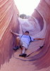
12:30 PM - Matty's Fork stopped me cold. What a stunning little gulch! What a welcome bit of shade! There was simply no resisting a quick explore down the creek bed on foot. Noshing and extra hydrating was done. Water was not flowing in the stream bed, but there may have been some under the sand. From Matty's, finding the remnants of Quien Sabe required patience, GPS and a huge cairn. Even then I repeatedly lost it in the high grass, or did I? Who knows? ;) Nearing the junction with Skull Mesa, there was a short section of trail utterly choked with Desert Holly (or something similar) that required more hacking to pass.
1:18 PM - Skull Mesa Trail east of the mesa is really sketchy, eroded, and a tricky thing to follow. A pair of red-tailed hawks circled and screamed above Quien Sabe Peak. As a boy growing up in the rain forest of the northwest, I dreamed of being a bald eagle. Now, in the desert southwest, the dream soars on tawny wings and super-heated updrafts. Uh-oh, all the route finding, daydreaming and playing with the machete were putting me way behind schedule. No mechanical issues with the bike though, so things were sure to get better. They didn't - at least not yet. Finding the cut where the trail drops off the shoulder of Quien Sabe Peak down to Cottonwood required wandering, backtracking, GPS and a few extra minutes. The downhill section of this trail is a nasty gutter. Being solo, I dared not attempt riding down the steep, loose-powder, jumbled garbage chute sections. Further down, off in the weeds (literally) I abused a prickly pear with my front tire and had to futz with the tire to get it to seal up. Yep, getting further behind schedule.
3:05 PM - Finally, I made it down off the mesas and into Cottonwood Creek. Yesssssss!!! Thank you, Jesus and praise to Allah! Just upstream from the trail junction was a shady spot where two arms of the drainage came together and the creek flowed strong. I dug a small depression, and the silt quickly cleared leaving a pool of clean, cool water. I treated a couple liters, and snacked on some Dukes sausages and an RX bar. And there was a great rejoicing. After that, riding in the creek and sometimes alongside it on the Maricopa Trail was much more enjoyable than the chossy and choked mess I'd been through to this point. In fact, it was downright pleasant.
4:15 PM - Junction with Bronco Trail. Climbs too steep to climb were attempted, and when that didn't work there was pushing the bike uphill. And there was *lots* of this lung-busting fun. Not to worry, the trek was nearing its end. Good thing, too - the shadows were growing taller than my, uh...metaphors. Or something.
4:42 PM - Tank in the East Fork of Bronco Creek. Really, seriously, there was just One. Climb. Left. A nice little seep partway up the trail darkened the soil and gave off that unmistakable water-on-the-desert smell of life and salvation. Then it was smooth sailing down the ridge to Bronco Trailhead.
5:10 PM - Bronco Trailhead. 21.6 miles all wrapped up in a tidy 8 hours and 10 minutes overall. Moving time was 5 hours 29 minutes, and the moving avg was just about 4 mph. That's a solid day's work, and great solo adventure. |
|
Wildflowers Observation Isolated
|
|
 |
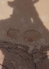
Quien Sabe Spring |
Dry |
Dry |
| | | Dark soil but no flow from the spring at the trail. I did not explore up to the spring itself | | _____________________
| | |
|
|
|
 Route Editor