|
| | | |
| |
|
| Car Camping | 0.50 Miles |
120 AEG |
| | Car Camping | 0.50 Miles | 4 Days | | |
| 120 ft AEG | | | | |
|
|
| |
| Linked |
|
none
[ show ]
| no linked trail guides |
| Partners |
|
[ show ]
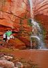
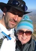
| partners | | This was a trip we will NEVER forget- BEARS, WATERFALLS, WILD HORSE FIGHT, MAD COW, OH MY! Kyle took a few days off work while I was on break from school so we could beat the record-breaking heat and spend some time in the high country. Two years ago we explored Pacheta Falls, then two weeks later the Wallow fire devastated the surrounding area. We wanted to make a trip back to see how bad it was, and to see if the falls would ever be the same again.
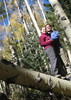
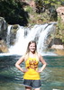
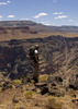
In no rush, we made it to Big Lake for camp the first night. There were SO many boats on the lake, but luckily we found a secluded camp spot for the night. Kyle woke up incredibly excited to surprise me with pancakes for breakfast. Mmmmm.  We took our time enjoying some of the other lakes on the way to our destination. Kyle threw in the pole at Reservation Lake, Drift Fence Lake, and then Pacheta Lake where he caught a few. We meandered our way to the falls and had the place to ourselves yet again. SCORE! Immediately we got out of the truck and followed the sound of running water. We were pleased to see that the fire had done little harm to this beautiful place. It was obvious the fire had gone through the area, but it was a clean burn and not nearly as devastating as we expected. We made several trips from the truck back to the falls throughout the evening and even into the early morning, hoping for the perfect photo. Kyle nailed the waterfall photos on this trip! We took our time enjoying some of the other lakes on the way to our destination. Kyle threw in the pole at Reservation Lake, Drift Fence Lake, and then Pacheta Lake where he caught a few. We meandered our way to the falls and had the place to ourselves yet again. SCORE! Immediately we got out of the truck and followed the sound of running water. We were pleased to see that the fire had done little harm to this beautiful place. It was obvious the fire had gone through the area, but it was a clean burn and not nearly as devastating as we expected. We made several trips from the truck back to the falls throughout the evening and even into the early morning, hoping for the perfect photo. Kyle nailed the waterfall photos on this trip!
After a quick breakfast we spotted a group of 4 or so wild horses trotting close to camp. Then all of a sudden 2 of the horses got into a frenzy kicking and stirring up dirt for a few minutes. It was interesting to watch, but man do I never want to be on the tail end of a bucking horse. Anyway, we packed up camp and headed out. “You better be watching for animals” rings through my ears on every trip with Kyle and I was determined to find more than the elk, deer, and turkeys we had seen the day before. About 20 minutes into the drive I thought to myself, “I should tell Kyle to pull over so I can put my zoom lens on…. I feel like we are going to see something cool today.” Literally 2 minutes later I spotted a healthy and absolutely stunning bear super close to the road standing broad side watching us. Kyle stopped the truck, we scrambled to get our zoom lenses on and then jumped out of the truck in flip flops, not even thinking twice about how stupid this decision could be.  The bear quickly retreated, but stopped long enough to stare Kyle down while he snapped a few pictures with both our cameras. High fives followed and we were back on the road. Not even 30 minutes later, and still hyped-up from our first bear encounter, I spotted a cub foraging for food. The bear quickly retreated, but stopped long enough to stare Kyle down while he snapped a few pictures with both our cameras. High fives followed and we were back on the road. Not even 30 minutes later, and still hyped-up from our first bear encounter, I spotted a cub foraging for food.  We stayed in the truck this time, expecting mom to be close by. We never saw mom, but boy did this cub pose perfectly for our cameras! We certainly hope the little guy wasn’t alone… We stayed in the truck this time, expecting mom to be close by. We never saw mom, but boy did this cub pose perfectly for our cameras! We certainly hope the little guy wasn’t alone…
Again, we got back into the truck thinking our luck just HAD to be over now. We were headed to the spot we camped at 2 years ago. Once at the reservation boundary, the gate was locked so Kyle got out to search for a way around. I stayed in the truck and thought it would be a good time to look through my photos. As Kyle was walking back to the truck, I looked up at him and caught glimpse of yet ANOTHER BEAR behind him and down the road a bit! Kyle hurried into the truck, got us around the locked gate in record time so we could capture a few quick photos of this gnarly looking bear. We weren’t as lucky getting pictures of this guy, but we are still shocked that we saw 3 bears all within an hour! We were wide-eyed with huge smiles the entire rest of the day! 
The rest of the drive was not as exciting, although we did see several more elk. I’m in love with the Alpine area and looking forward to a return for more adventures. On the way back, we camped the last night at Patrick’s Pond- a childhood favorite for Kyle and his family. Kyle enjoyed destroying the crawdad population in the pond with his BB gun, while I sipped on my wine watching my boyfriend turn into a 10 year old. We hoped for some rain to clean off Kyle’s sancha (aka his truck), but only got a mere drop or two. In the morning we woke up to a mad cow running (literally running) circles around camp and moo-ing up a storm. I actually felt bad for this poor stressed out cow.
And that about does it for our wild adventure! Can’t wait to get the cub picture posted for ya’ll to see! |
| _____________________
| It is easier to go down a hill than up it but the view is much better at the top. - Henry Ward Beecher |
| | |
|
|
|
 Route Editor


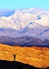


 . Our return trip on Sunday was beautiful watching the clouds lift out from the valleys.