|
| | | |
| |
|
| Hiking | 14.33 Miles |
3,266 AEG |
| | Hiking | 14.33 Miles | 9 Hrs 40 Mns | | 1.91 mph |
| 3,266 ft AEG | 2 Hrs 10 Mns Break | | | |
|
|
| |
| Linked |
|
none
[ show ]
| no linked trail guides |
| Partners |
|
none
[ show ]
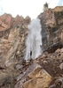
| no partners | | My third trip to Reavis Falls, second time for Gen, first time for the rest of the group. Apache Trail is still blocked off, despite what Google Maps says, so we had to take 188 around. The last 3 miles are rougher than I remember, but almost any vehicle can still make it.
Started at 0800. Temp was high 50s, but quickly warmed up. First 3 miles were quick, but we stopped for a while for a photoshoot at a large flower patch. The downhill is a little slower with all the loose rocks, but still went by quickly. The creek was very pleasant, had medium flow, was at least 3 feet deep in some areas, and required over 20 crossings, but we kept our feet dry.
The falls were excellent. I've seen pictures of it with stronger flow, but this was nice. We hung out there at least 90 minutes. Everyone took a swim. The water was bone-chilling, but we were pretty warm at that point, and everyone was doing it. One of our group had heat exhaustion, so we had to get him fully resuscitated before the uphill climb back. We all jumped in the creek again before beginning the climb, and it helped.
The return trip was a bit slower, but enjoyable with good people and good vibes. Overall excellent trip. Only saw 2 other people the entire day, and they were leaving the creek as we were approaching it. |
|
Wildflowers Observation Moderate
|
|
| | |
|
|
|
 Route Editor


 Woke at 4:30 and two others agreed to our wacky plan. Dark for most of the drive during winter solstice week. 1st time through Fish Creek Hill.
 Tagged a bonus peak. Scouted a future off trail peak. Finished an hour quicker than expected.

 However, be aware that you will face damn near every type of challenge possible along the way. RF, off trail, boulder hopping & many water crossings. Then miles 10-12 are all relentless uphill.


 . Falls were cold and windy, but still running great. We were the only people there for awhile before others starting coming in. Beautiful day and tough hike