|
| | | |
| |
|
| Hiking | 7.51 Miles |
1,326 AEG |
| | Hiking | 7.51 Miles | 5 Hrs 14 Mns | | 1.63 mph |
| 1,326 ft AEG | 37 Mns Break | | | |
|
|
| |
| Linked |
|
none
[ show ]
| no linked trail guides |
| Partners |
|
none
[ show ]
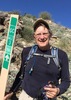
| no partners | | | My daughter, Amy, and I completed a 7.5 mi loop, starting at the Canyon Lake trailhead. We followed the La Barge Creek through Boulder Canyon to the Boulder Canyon Trail. The La Barge Creek Route is a lot of boulder hopping and therefore much slower than an established trail. There was only one spot where we had to squeeze through a slot between the canyon wall and large boulders to get around a large pool of water. We stopped for lunch at the Indian Paint Mine, before returning to the Canyon Lake trailhead via the Boulder Canyon trail. As usual, there were spectacular views of Battleship Mountain, Weavers Needle and Canyon Lake from the higher elevations on the Boulder Canyon Trail. |
| | |
|
|
|
 Route Editor