 Route Editor

| Guide | ♦ | 22 Triplogs | 1 Topic |
details | drive | permit | forecast | 🔥 route |
stats |
photos | triplogs | topic | location |
| 396 | 22 | 1 |
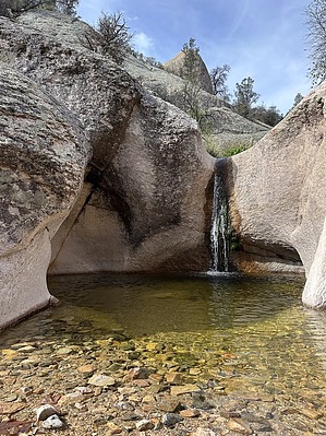
The Trail That Isn’t, Along a Stream That Won’t Commit by GrangerGuy   Overview OverviewThe Black Rock Canyon Trail has no clear beginning, middle, or end. There are no signs anywhere, and mostly no trail, either, but it is easy enough to follow. The best starting point is Reef Tank, as there is good parking there, and that is where it closes the loop with the Holdout Creek Trail. One could say that it ends at the boundary of the North Santa Teresa Wilderness with a ranch property, but that is essentially a dead end. The creek comes up out of the sand and disappears many times, Hassayampa-style. Hike A good place to start the hike is at Reef Tank in Coronado National Forest. There is parking and camping at that location. From there, hike back up the Road 68 you drove in on, then turn right onto Road 941, which is in terrible condition. At about 1.7 miles from Reef Tank, there is an easily missed road to the left through a gate, and at 2 miles, the route turns right to follow along the wilderness boundary. At 2.3 miles would be the official beginning of the trail, where it turns across the unmarked wilderness boundary and plunges downhill to the bottom of the canyon. Theoretically, you could park here, but it would be a challenging drive in any vehicle.
Continue down the canyon, and at 7.7 miles, arrive at the intersection with the Holdout Creek Trail. Just up the bank to the left is a large meadow and a corral, which makes a great spot to camp overnight. From here, officially, trail #292 continues down the canyon, but we did not spot any constructed trail after this point. In 1.4 miles from the Holdout Creek Trail intersection, the route crosses from the Santa Teresa Wilderness into the North Santa Teresa Wilderness, and a change in jurisdiction from USFS to BLM. At 3.2 miles, the trail comes to its official end at Forest Road 94, but that road is on private property, and word has it that it is closed to the public. Gate Policy: If a gate is closed upon arrival, leave it closed after you go through. If it is open, leave it open. Leaving a closed gate open may put cattle in danger. Closing an open gate may cut them off from water. Please be respectful, leave gates as found. The exception is signage on the gate directing you otherwise. Check out the Official Route and Triplogs. Leave No Trace and +Add a Triplog after your hike to support this local community. One-Way Notice This hike is listed as One-Way. When hiking several trails on a single "hike", log it with a generic name that describes the hike. Then link the trails traveled, check out the example. | |||||||||||||||||||||||||||||||||||||||||||||||||||||||||||||||||||||||||||||||||||||||||||||||||||||||||||||||||||||||||||||||||||||||||||||||||||||||||||||||||||||||||||||||||||||||||||||||||||||||||||||||


