username
X
password
register
for free!
help


Crosscut Trail - South Mountain, AZ

Guide 37 Triplogs  0 Topics
  2.3 of 5  
Fav
Wish
0
details
drive
no permit
forecast
route  
stats
photos
triplogs
topics
location
124 37 0
HAZ reminds you to respect the ruins. Please read the Archaeological Resources Protection Act of 1979 & Ruins Etiquette
Statistics
tap row or icons for details
Difficulty 1.5 of 5
Route Finding 2 of 5
Distance One Way 2.3 miles
Trailhead Elevation 1,348 feet
Elevation Gain 337 feet
Accumulated Gain 433 feet
Avg Time One Way 1 hour
Kokopelli Seeds 3.74
 Interest Ruins
 Backpack No
feature photo
Photos Viewed All MineFollowing
Will recalculate on button tap!
12  2026-02-13
South Mountain Valley Wander
GrangerGuy
10  2026-01-31
Alta Hau'Pal Crosscut Las Lomitas Ranger
GrangerGuy
15  2025-03-05
Hau'Pal Trail
kingsnake
12  2024-01-15
Hau'Pal Trail
Tortoise_Hiker
4  2023-11-04
Maricopa Peak
trekkin_gecko
3  2023-11-04
Maricopa Peak
johnlp
5  2023-10-21
South Mountain Meander
ddgrunning
18  2023-03-20
Judith Tunell Interpretive Trail - South Mtn
Tortoise_Hiker
Page 1,  2
Author
author avatar Guides 36
Routes 153
Photos 1,071
Trips 124 map ( 1,487 miles )
Age 69 Male Gender
Location Phoenix, AZ
Associated Areas
list map done
Phoenix Region
Historical Weather
Trailhead Forecast
Radar Map
Expand Map
Preferred Jan, Dec, Feb, Nov → 8 AM
Seasons   Autumn to Spring
Sun  6:53am - 6:28pm
Official Route & 3 Rts
 
12 Alternative


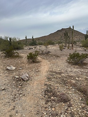
Horses, Sandy Wash, What's not to Like?
by GrangerGuy

 
Expand MapOverview
Much of this trail is used for trail rides leaving from the stables by the park entrance. The first mile is in a sandy wash. As such, it's not a great walking route until it crosses the main park road, where the horses are mostly left behind.


Hike
After parking near Scorpion Gulch at the park entrance, walk through the ruins and down the wash embankment behind the old buildings. Turn right in the wash and stay in the wash for about 0.7 miles. Watch for a sharp left into a small side canyon, which takes you up out of the wash onto higher ground.
remove free decal offer
In 0.1 mile, you will intersect a connector trail that makes a sharp left back toward the Las Lomitas Trail. In another 0.1 mile, you will encounter a couple of corrals and a parking lot, and the trailhead for the Ranger Trail. Here, the Crosscut Trail makes a sharp right and heads across the main park road.

Just after the park road, the trail turns left, briefly coincident with the Max Delta Trail, and then turns right up the hill toward the Big Ramada, where it passes the trailhead for the Ma-Ha-Tuak Perimeter Trail heading off toward the 19th Ave. Trailhead. The route continues up the end of the Ma-Ha-Tuak range and intersects the Hua'Pal Loop Trail (Formerly T-Bone Loop), another way to the 19th Ave. parking. Turning left and down the hill, the trail again intersects the Max Delta Trail, where the Crosscut Trail ends.

2026-02-14 GrangerGuy
  • 2022 South Mountain Park
    area related
    2022 South Mountain Park


Check out the Official Route and Triplogs.
Leave No Trace and +Add a Triplog after your hike to support this local community.

One-Way Notice
This hike is listed as One-Way.

When hiking several trails on a single "hike", log it with a generic name that describes the hike. Then link the trails traveled, check out the example.
WARNING! Hiking and outdoor related sports can be dangerous. Be responsible and prepare for the trip. Study the area you are entering and plan accordingly. Dress for the current and unexpected weather changes. Take plenty of water. Never go alone. Make an itinerary with your plan(s), route(s), destination(s) and expected return time. Give your itinerary to trusted family and/or friends.

 Permit $$
None


 Directions
or
 Road
Paved - Car Okay

To hike
From Phoenix, take Central Road south into the park. Park in the lot by the riding stables and Scorpion Gulch before the entrance station to South Mountain Park.
page created by neilends on Feb 14 2026 4:16 pm
helpcorrectionissue

end of page marker