username
X
password
register
for free!
help


East Fagan Foothills 5102, AZ

Guide 1 Triplog  0 Topics
  2 of 5  
Fav
Wish
0
details
drive
permit
forecast
route  
stats
photos
triplog
topics
location
2 1 0
Statistics
tap row or icons for details
Difficulty 2 of 5
Route Finding 2 of 5
Distance Lasso-Loop 7.54 miles
Trailhead Elevation 4,004 feet
Elevation Gain 1,088 feet
Accumulated Gain 1,308 feet
Avg Time Round Trip 2.5 hours
Kokopelli Seeds 14.08
 Backpack Possible - Not Popular
feature photo
Photos Viewed All MineFollowing
2  2025-01-18 pseudalpine
Author
author avatar Guides 59
Routes 1,100
Photos 1,191
Trips 1,290 map ( 9,859 miles )
Age Male Gender
Location Arizona
Historical Weather
Trailhead Forecast
Radar Map
Expand Map
Preferred Oct, Nov, Feb, Mar → 7 AM
Seasons   Autumn to Spring
Sun  6:00am - 6:42pm
Official Route
 
0 Alternative


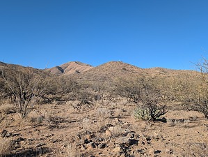
Sacaton Grassland Stroll
by pseudalpine

 
Overview
A pleasant loop southeast of Tucson that integrates a section of Las Colinas - AZT #6 on Arizona State Trust land, a more obscure conglomeration of "trails" and the Lake Road (FR 2862) in the northeastern foothills of Mount Fagan in the Coronado National Forest.


Hike
It's possible to park outside the State Trust gate to start this loop. The route generally tracks AZT #6, meandering through mainly Mesquite and Ocotillo for about two miles. South of The Lake near 4295 one must head west after crossing the Lake Road. Ducks along the obscure path guide one to a ravine crossing. Slightly north in the bed and then on the upper west side of this wash, one must gap a fence to enter the Coronado NF. The route then meticulously switchbacks up the ridge amongst Agave, Desert Spoon, and Prickly Pear (to name a few), eventually joining the 5102' turnabout terminus of FR 2852. Just northwest of this point is where the Mount Fagan East route starts/ends.
remove free decal offer
To return (CW), continue north on the undulating road at first, then mostly steeply descending where it'll swing more easterly leaving the Coronado NF at a gate. The road follows a wash for a way and then one will stay south (right) of The Lake to complete the lasso loop by following the rocky road east back down to AZ-83.

Gate Policy: If a gate is closed upon arrival, leave it closed after you go through. If it is open, leave it open. Leaving a closed gate open may put cattle in danger. Closing an open gate may cut them off from water. Please be respectful, leave gates as found. The exception is signage on the gate directing you otherwise.

2025-01-20 pseudalpine


    Check out the Official Route and Triplog.
    Leave No Trace and +Add a Triplog after your hike to support this local community.
    WARNING! Hiking and outdoor related sports can be dangerous. Be responsible and prepare for the trip. Study the area you are entering and plan accordingly. Dress for the current and unexpected weather changes. Take plenty of water. Never go alone. Make an itinerary with your plan(s), route(s), destination(s) and expected return time. Give your itinerary to trusted family and/or friends.

     Permit $$
    AZ State Recreational Land Permits
    For hiking, driving & sightseeing purposes, you seek a recreational permit.
    Under "Recreational Land Use" in the link above.
    2022 - $15.00 individual
    2022 - $20.00 family limited to two adults and children under the age of 18
    Plus $1 processing fee
    The permitting process is quick, you will be emailed your permit instantly.

    Land Parcel Map

    Coronado Forest
    MVUMs are rarely necessary to review unless mentioned in the description or directions
    Coronado Motor Vehicle Use Maps (MVUMs)


     Directions
    or
     Road
    Paved - Car Okay

    To hike
    From I-10 Exit 281, AZ-83 south to Mile Marker 51.4 at FR 2852 near Twin Tanks.
    page created by pseudalpine on Jan 20 2025 8:17 pm
     90+° 8am - 6pm kills
    helpcorrectionissue

    end of page marker