Overview
Las Colinas - AZT #6 from the south starts with a short road walk to the trail, as described in directions. Then follows the well-defined trail through rolling hills, across several ridges and washes, as it makes its way to Twin Tanks, just off Lakes Road south of Interstate 10.
Hike
Hike northbound on a good trail through oak-lined grasslands, up brief climbs with a combination of fast descents and gradual descending ridge walks. Long vistas give rise to brief glimpses of white-tailed deer as they run for cover. While the elevation at the end of the trail indicates over 1000 feet of descent, this can be deceptive because there is considerable accumulated elevation gain.
If backpacking, there are several places along the way to camp. Including some nicely leveled spots high on the ridges and some excellent tree-covered areas in the washes. One wash in particular about 5 miles north has some lovely spots that would be perfect in warmer weather.
Water Sources
The only water along the trail is at the end - a disgusting cattle 'tank' (i.e., mud puddle) where a strainer and filter are highly recommended.
When hiking several trails on a single "hike", log it with a generic name that describes the hike. Then link the trails traveled, check out the example.
WARNING! Hiking and outdoor related sports can be dangerous. Be responsible and prepare for the trip. Study the area you are entering and plan accordingly. Dress for the current and unexpected weather changes. Take plenty of water. Never go alone. Make an itinerary with your plan(s), route(s), destination(s) and expected return time. Give your itinerary to trusted family and/or friends.
Permit $$
no fees or permits reported
if incorrect tell us about it
Coronado Forest MVUMs are rarely necessary to review unless mentioned in the description or directions Coronado Motor Vehicle Use Maps (MVUMs)
Directions
Road
Paved - Car Okay
To hike Take Interstate 10 east from Tucson to the junction with Highway 83 to Sonoita. Continue south on Highway 83 to described parking.
North TH
7.0 miles south of Interstate 10 at Lakes Road. Park just outside the gate, or continue with a high clearance vehicle 0.5 miles to the bottom of a wash just 100 yards downhill from where the trail crosses the road. Parking can be had at the top of the hill as well, but four-wheel drive is required to get there.
South TH
15.6 miles south of Interstate 10 in a pullout on the right side of Highway 83 past milepost 44. Space for one auto is located adjacent to a locked gate. Additional parking is a short distance to the left down a dirt drive. Walk the road, or, if parked down the drive, continue to the wash where a connector trail points the way to the Arizona Trail. Walk 0.6 miles west along the dirt road to find where the Arizona Trail crosses the road at the start of Passage 6.
 Route Editor

 Overview
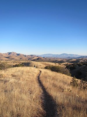


