Overview
East Fork #24A does not offer the dramatic desert landscapes or cascading waterfalls that make many other trails in the Pusch Ridge Wilderness so memorable. This 2.2-mile segment of the Arizona Trail is a fairly simple hike with views that are decent at best. However, #24A is a critical link between six popular trails: Sabino Canyon Trail #23, West Fork Trail #24, Bear Canyon Trail #29, Sycamore Reservoir Trail #39, Palisade Trail #99, and Box Camp Trail #22. Adventurous hikers looking to connect multiple trails and form their own unique hikes while escaping the crowds on Mt. Lemmon and Sabino Canyon are bound to find #24A essential. Although this trail can be hiked in any number of ways, I will describe it as hiked from West to East.
Hike
Starting at the Western terminus with Sabino Canyon #23 and West Fork Trail #24, East Fork #24A departs across the wash heading in a westward direction. This level section ends approximately one-tenth of a mile later where you encounter a signed intersection with Box Camp #22.
From here you continue straight along East Fork #24A as it follows its westward path and begins a very gradual climb in elevation as it skirts along the hillside and begins to follow the wash. At first, you find that you are above the wash looking down on stagnant pools of green water, but before long you find yourself at the same level as the wash as the trail stretches on. As you make your way closer to Palisade Trail #99 you will be treated to patches of shade provided by the oak trees that line the wash.
One mile past the intersection with Box Camp #22 you will arrive at the intersection with Palisade Trail #99. Those looking for a good spot to take a break would be wise to take advantage of this last opportunity for shade by the wash, as this final 1.1-mile segment will switchback up the hill as it works its way toward its Eastern terminus. Although the trail is not too steep, at least by Push Ridge Wilderness standards, it can be difficult with the midday sun beating down. At the top of the switchbacks, you will arrive at a saddle and be greeted with a signpost marking your arrival at the junction with Sycamore Canyon #39 and Bear Canyon #29, and the end of East Fork #24A.
When hiking several trails on a single "hike", log it with a generic name that describes the hike. Then link the trails traveled, check out the example.
WARNING! Hiking and outdoor related sports can be dangerous. Be responsible and prepare for the trip. Study the area you are entering and plan accordingly. Dress for the current and unexpected weather changes. Take plenty of water. Never go alone. Make an itinerary with your plan(s), route(s), destination(s) and expected return time. Give your itinerary to trusted family and/or friends.
Four specific day-use areas require a Coronado Recreational Pass or a National Pass/America the Beautiful Pass.
1) Sabino Canyon - located on the Santa Catalina Ranger District (520)749-8700
2) Madera Canyon - located on the Nogales Ranger District (520)281-2296
3) Cave Creek - located on the Douglas Ranger District (520)364-3468
4) Mt. Lemmon at 11 day-use sites.
2025Catalina State Park
Per vehicle (1 person): $10.00
Per vehicle (2-4 people): $20.00
Individual/bicycle: $5.00
Coronado Forest MVUMs are rarely necessary to review unless mentioned in the description or directions Coronado Motor Vehicle Use Maps (MVUMs)
Directions
Road
Connector trail - Not Applicable
To hike This connector trail can be accessed from multiple trails, either from Mt. Lemmon or Sabino Canyon:
Bear Canyon #29: 8.3 miles from the main Sabino Canyon Parking lot or 7.1 miles from Bear Canyon Rd Parking lot
Sycamore Reservoir #39: 4.35 miles
Palisade #99: 6.2 miles
Box Camp #22: 7.1 miles
------------------------------
Sabino Canyon #23: 2.5 miles*
West Fork #24: 2.2 miles*
*Both Sabino Canyon #23 and West Fork #24 are connector trails themselves and numerous options exist to reach them, mileage provided is for the specific trail segment. Hikers looking to access #24A using these options must do further research to determine actual distance.
 Route Editor

 Overview
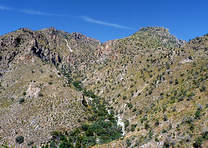


