 Route Editor

| Guide | ♦ | 140 Triplogs | 3 Topics |
details | drive | permit | forecast | 🔥 route |
stats |
photos | triplogs | topics | location |
| 902 | 140 | 3 |
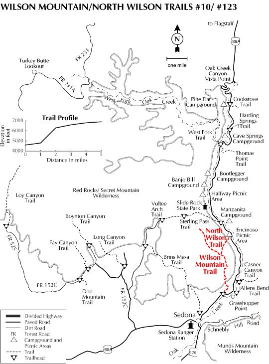
Forest over Sedona! by joebartels   Arizona is represented well on this rewarding trail. Parking can be a challenge in itself as this is a popular roadside viewing pullout. Park and head on over to the picnic ramada. Check out the trail map. The first step on this trail is up, as are most. Immediately you enter a typical Sedona forest. It's easy to appreciate Sedona on this trail from the beginning. Healthy manzanita against the deep red soil is perfect. Excellent photo opportunities are present early on in the trail. Including an overview shot of the Midgely bridge with Oak Creek running south. After a few switchbacks, the trail levels out as it heads on over to Wilson Mountain. The noise from 89A goes away. Look up at Wilson Mountain. The top is capped with a dark volcanic basalt. To the right appears to be a grassy saddle. This is the First Bench of Wilson Mountain. It's a long way to the first bench so set a good pace. Along this stretch, you will pass under two sets of power lines. Just before the level terrain gives way to a knee burning ascent a junction is encountered for Wilson Canyon Trail #49 and Jim Thompson Trail #124. Arizona is represented well on this rewarding trail. Parking can be a challenge in itself as this is a popular roadside viewing pullout. Park and head on over to the picnic ramada. Check out the trail map. The first step on this trail is up, as are most. Immediately you enter a typical Sedona forest. It's easy to appreciate Sedona on this trail from the beginning. Healthy manzanita against the deep red soil is perfect. Excellent photo opportunities are present early on in the trail. Including an overview shot of the Midgely bridge with Oak Creek running south. After a few switchbacks, the trail levels out as it heads on over to Wilson Mountain. The noise from 89A goes away. Look up at Wilson Mountain. The top is capped with a dark volcanic basalt. To the right appears to be a grassy saddle. This is the First Bench of Wilson Mountain. It's a long way to the first bench so set a good pace. Along this stretch, you will pass under two sets of power lines. Just before the level terrain gives way to a knee burning ascent a junction is encountered for Wilson Canyon Trail #49 and Jim Thompson Trail #124.Continue, which is up, and soon encounter the trail register. The trail begins to get rocky and is less defined. Less impressive vegetation is encountered. Just shy but near level with Steamboat Rock small size boulders litter the trail. At this point, grass surrounds the trail and you begin to feel more comfortable that you're on track. I passed a huge mushroom. It was at least eight inches in diameter and seemed out of place in this dry area. A ravine is encountered and things get a bit more exciting. Look over your shoulder for some scenic rewards. A gnarly picturesque pine is passed crossing the ravine for the first time. Once on the other side of the ravine look over to your right and you are basically level with Steamboat Rock. The vegetation thickens up. You will know your destination at this point. To be honest it's a bit discouraging looking at the task ahead.
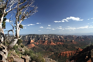
Continuing left from the junction a couple long and switchbacks deliver you to the nearly flat top. At the turn of the first switchback is a magnificent view of the San Francisco peaks. At 4 miles you come to a junction with the southern overlook. The 2006 Brins Mesa Fire torched the forest. I highly recommend the southern overlook ( turn left ). It only adds a little bit of gain and is under a mile round trip. An old metal locker previously used for water and shovels to aid in battling fires is encountered quickly on that jaunt. For #10 proper take a right at the junction continuing an easy 1.5 miles to the northern overlook. The view is impressive with Oak Creek on your right leading to the San Francisco Peaks. Head-on is East Pocket which A.B. Young Trail #100 ascends to out of Oak Creek. The lookout tower on top may take a few minutes of squinting to find. Vultee Arch is down to your left in the maze or Supai sandstone. Camping According to the 2018 FS map camping is allowed outside the green line. If you can't read a map, do not camp anywhere on planet earth. Note The 2006 Brins Fire burned hot in areas on this mountain. A majority of the pines are gone. The views are still majestic and you may find the remaining pines simply special.
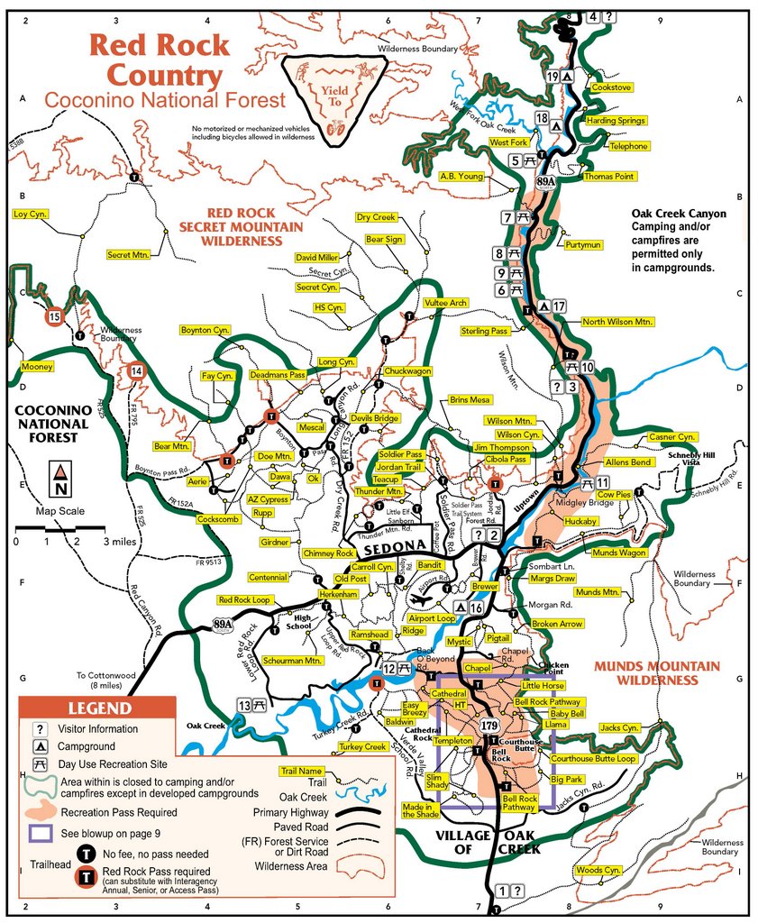
Coconino FS Details This hike heads straight for some of the most panoramic views in the Oak Creek Canyon/Sedona area. Plan a full day for it and start early - the climb up Wilson Mountain is a strenuous one. The majority of the 2300 foot climb is packed into the first mile or so of the hike. You'll have more reasons than just exertion to stop and take a breather along this route, however. The views start as soon as you leave the car and they just keep getting better. There is shade along parts of this trail but enough of it is out in the open to make it hot work under a summer sun. An alternate, cooler route is provided by North Wilson Trail which starts just north of Encinoso Picnic Area, 3 miles up canyon from Midgely Bridge. The two trails join at a point midway up the mountain. At the top you'll be rewarded with views that stretch over hundreds of square miles of scenic canyon country and include Oak Creek Canyon, Sedona, Coffee Pot Rock, Capitol Butte, Sterling Canyon and the Verde Valley.
Check out the Official Route and Triplogs. Leave No Trace and +Add a Triplog after your hike to support this local community. | |||||||||||||||||||||||||||||||||||||||||||||||||||||||||||||||||||||||||||||||||||||||||||||||||||||||||||||||||||||||||||||||||||||||||||||||||||||||||||||||||||||||||||||||||||||||||||||||||||||||||||||||||||||||||||


